Datei:Map of Afghanistan, Districts and Provinces.svg
Zur Navigation springen
Zur Suche springen

Größe der PNG-Vorschau dieser SVG-Datei: 750 × 475 Pixel. Weitere aus SVG automatisch erzeugte PNG-Grafiken in verschiedenen Auflösungen: 320 × 203 Pixel | 640 × 405 Pixel | 1.024 × 649 Pixel | 1.280 × 811 Pixel | 2.560 × 1.621 Pixel
Originaldatei (SVG-Datei, Basisgröße: 750 × 475 Pixel, Dateigröße: 2,57 MB)
![]()
Diese Datei und die Informationen unter dem roten Trennstrich werden aus dem zentralen Medienarchiv Wikimedia Commons eingebunden.
![]()
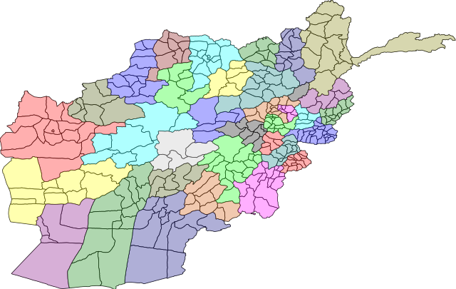
| Beschreibung | A map of the districts of Afghanistan. The districts are colour grouped by province. | |||||
| Datum | ||||||
| Quelle |
Map originally from Maplibrary.org who in turn have extracted it from GADM version 0.9 which source the data for Afghanistan as comming from the USGS.
|
|||||
| Urheber | USGS and Lokal_Profil | |||||
| Genehmigung (Weiternutzung dieser Datei) |
|
|||||
| Andere Versionen |
|


Dateiversionen
Klicke auf einen Zeitpunkt, um diese Version zu laden.
| Version vom | Vorschaubild | Maße | Benutzer | Kommentar | |
|---|---|---|---|---|---|
| aktuell | 22:31, 1. Mär. 2009 | | 750 × 475 (2,57 MB) | Lokal Profil | {{Information |Description=A map of the districts of Afghanistan. The districts are colour grouped by province. |Source=Map originally from [http://www.maplibrary.org/stacks/gadm/AFG/index.php Maplibrary.org] who in turn have extracted it from [http://bio |
Dateiverwendung
Die folgende Seite verwendet diese Datei:
Globale Dateiverwendung
Die nachfolgenden anderen Wikis verwenden diese Datei:
- Verwendung auf eo.wikipedia.org
- Verwendung auf he.wikipedia.org
- מחוזות אפגניסטן
- קונדוז (מחוז)
- תבנית:מחוזות אפגניסטן
- הראת (מחוז)
- פראה (מחוז)
- גור (מחוז)
- באדגיס
- נימרוז
- הלמנד (מחוז)
- קנדהאר (מחוז)
- אורוזגאן
- דאיכונדי
- ע'זני (מחוז)
- זאבול
- פכתיכא
- מיידאן ורדכ
- באמיאן
- סר-י פול (מחוז)
- פאריאב
- בלח' (מחוז)
- סמנגאן
- בגלאן (מחוז)
- תח'אר
- פרוואן
- ח'וסת (מחוז)
- פכתיא
- ג'וזג'אן
- לוגר (מחוז)
- כאפיסא
- ננגרהאר
- לגמאן
- קאבול (מחוז)
- כונר
- נורסתאן
- פנג'שיר
- בדח'שאן
- Verwendung auf hi.wikipedia.org
Weitere globale Verwendungen dieser Datei anschauen.