Datei:Akecoregions.jpg
Zur Navigation springen
Zur Suche springen
Größe dieser Vorschau: 778 × 600 Pixel. Weitere Auflösungen: 311 × 240 Pixel | 623 × 480 Pixel | 996 × 768 Pixel | 1.270 × 979 Pixel
Originaldatei (1.270 × 979 Pixel, Dateigröße: 236 KB, MIME-Typ: image/jpeg)
![]()
Diese Datei und die Informationen unter dem roten Trennstrich werden aus dem zentralen Medienarchiv Wikimedia Commons eingebunden.
![]()
Beschreibung
| Beschreibung |
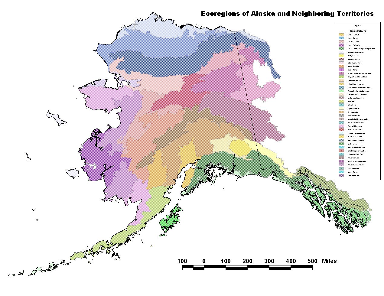
English: "Unified Ecoregions of Alaska: 2001. This ecoregion map combines the Bailey and Omernik approach to ecoregion mapping in Alaska. The ecoregions were developed cooperatively by the U.S. Forest Service, National Park Service, U.S. Geological Survey, The Nature Conservancy, and personnel from many other agencies and private organizations."
Quoted from source (Metadata): The Ecoregion units are arranged in two higher levels along
gradients of climate, vegetation and disturbance processes.
Thirty two ecoregions fit into eight groups at Level 2, and
three regimes at Level 1 (Boreal, Maritime and Polar).
Please refer to the tri-archy found on the back of the
published map. Written descriptions are located in the
section of Overview Description, following the individual
ecoregional descriptions.
Level 1 Level 2 Ecoregion
Polar (-like)
Arctic Tundra
Beaufort Coastal Plain
Brooks Foothills
Brooks Range
Bering Tundra
Kotzebue Sound Lowlands
Seward Peninsula
Bering Sea Islands
Boreal (-like)
Bering Taiga
Nulato Hills
Yukon-Kuskokwim Delta
Ahklun Mountains
Bristol Bay Lowlands
Intermontane Boreal
Kobuk Ridges and Valleys
Ray Mountains
Davidson Mountains
Yukon-Old Crow Basin
North Ogilvie Mountains
Yukon-Tanana Uplands
Tanana-Kuskokwim Lowlands
Yukon River Lowlands
Kuskokwim Mountains
Alaska Range Transition
Lime Hills
Alaska Range
Cook Inlet Basin
Copper River Basin
Maritime (-like)
Aleutian Meadows
Alaska Peninsula
Aleutian Islands
Coastal Rainforests
Alexander Archipelago
Boundary Ranges
Chugach-St. Elias Mountains
Gulf of Alaska Coast
Kodiak Island
Coast Mountains Transition
Wrangell Mountains
Kluane Range
end quote |
| Datum | |
| Quelle | [1] Alaska Geospatial regions clearinghouse; Ecoregions of Alaska: 2001. U.S. Geological Survey Open-File Report 02-297 (map). |
| Urheber | Nowacki, Gregory; Spencer, Page; Fleming, Michael; Brock, Terry; and Jorgenson, Torre ; USGS and other agencies |
Lizenz
Dieses Werk ist in den Vereinigten Staaten gemeinfrei, da es von Mitarbeitern der US-amerikanischen Bundesregierung oder einem ihrer Organe in Ausübung ihrer dienstlichen Pflichten erstellt wurde und deshalb nach Titel 17, Kapitel 1, Sektion 105 des US Code ein Werk der Regierung der Vereinigten Staaten von Amerika ist.
Achtung: Dies bezieht sich nur auf originale Werke der Bundesregierung oder eines ihrer Organe, jedoch nicht auf Werke der Regierung eines Bundesstaates oder einer lokalen Behörde. Ebenfalls ausgeschlossen sind seit 1978 herausgegebene Briefmarken und bestimmte Geldmünzen.
|
 | |
| Es wurde festgestellt, dass diese Datei frei von bekannten Beschränkungen durch das Urheberrecht ist, alle verbundenen und verwandten Rechte eingeschlossen. | ||
Dateiversionen
Klicke auf einen Zeitpunkt, um diese Version zu laden.
| Version vom | Vorschaubild | Maße | Benutzer | Kommentar | |
|---|---|---|---|---|---|
| aktuell | 17:05, 27. Jul. 2012 | | 1.270 × 979 (236 KB) | Dankarl |
Dateiverwendung
Die folgende Seite verwendet diese Datei: