Datei:China Gansu rel location map.svg

Originaldatei (SVG-Datei, Basisgröße: 998 × 789 Pixel, Dateigröße: 724 KB)
![]()
Diese Datei und die Informationen unter dem roten Trennstrich werden aus dem zentralen Medienarchiv Wikimedia Commons eingebunden.
![]()
Beschreibung
| Beschreibung |
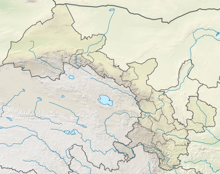
Deutsch: Positionskarte von Gansu, Volksrepublik China
English: Location map of Gansu, People's Republic of China
|
||||||||||||
| Datum | |||||||||||||
| Quelle |
Eigenes Werk mittels:
|
||||||||||||
| Urheber | NordNordWest | ||||||||||||
| Andere Versionen |
|
||||||||||||


|
Diese Karte wurde in der Kartenwerkstatt erstellt oder verbessert. Auch du kannst dort Karten vorschlagen, die zu erstellen, verändern oder übersetzen sind.
|
Lizenz
Weiternutzung dieser Karte mit:

Rechtsgültig ist alleine der Lizenzvertrag in seinem Wortlaut. Für eine kostenlose Weiternutzung empfehle ich besonders die Beachtung folgender Lizenzbedingungen:
1. Fügen Sie meinen Namen wie oben angegeben bei: NordNordWest,
2. eine Kopie dieser Lizenz oder deren vollständige Internetadresse bei: https://creativecommons.org/licenses/by-sa/3.0/de/legalcode
3. und im Falle einer Abwandlung einen Hinweis darauf, dass es sich um eine Abwandlung handelt.
Im Falle eines Verstoßes gegen die Lizenzbedingungen erlöschen die eingeräumten Nutzungsrechte automatisch.
Wenn Sie Fragen haben oder andere Nutzungsbedingungen wünschen, kontaktieren Sie mich bitte über nnwest oder hinterlassen mir eine Nachricht auf meiner Diskussionsseite (unangemeldet möglich). Ich freue mich über Mitteilungen, wo meine Karten verwendet werden, oder Belegexemplare. ![]() t-online.de
t-online.de
- Dieses Werk darf von dir
- verbreitet werden – vervielfältigt, verbreitet und öffentlich zugänglich gemacht werden
- neu zusammengestellt werden – abgewandelt und bearbeitet werden
- Zu den folgenden Bedingungen:
- Namensnennung – Du musst angemessene Urheber- und Rechteangaben machen, einen Link zur Lizenz beifügen und angeben, ob Änderungen vorgenommen wurden. Diese Angaben dürfen in jeder angemessenen Art und Weise gemacht werden, allerdings nicht so, dass der Eindruck entsteht, der Lizenzgeber unterstütze gerade dich oder deine Nutzung besonders.
- Weitergabe unter gleichen Bedingungen – Wenn du das Material wiedermischst, transformierst oder darauf aufbaust, musst du deine Beiträge unter der gleichen oder einer kompatiblen Lizenz wie das Original verbreiten.

Dateiversionen
Klicke auf einen Zeitpunkt, um diese Version zu laden.
| Version vom | Vorschaubild | Maße | Benutzer | Kommentar | |
|---|---|---|---|---|---|
| aktuell | 19:49, 24. Apr. 2022 | | 998 × 789 (724 KB) | NordNordWest | == {{int:filedesc}} == {{Information |Description= {{de|1=Positionskarte von Gansu, Volksrepublik China}} {{en|1=Location map of Gansu, People's Republic of China}} {{Location map series N |stretching=126 |top=43 |bottom=32.4 |left=92.1 |right=109 }} |Source={{Own using}} * United States National Imagery and Mapping Agency data * World Data Base II data * ETOPO1 data |Date=2022-04-24 |Author={{U|NordNordWest}} |Permission= |other_versions=<gallery>China Gansu adm location map.svg</gallery> }}... |
Dateiverwendung
Die folgenden 9 Seiten verwenden diese Datei:
Globale Dateiverwendung
Die nachfolgenden anderen Wikis verwenden diese Datei:
- Verwendung auf bn.wikipedia.org
- Verwendung auf en.wikipedia.org
- Dunhuang
- Mogao Caves
- Yumen City
- Crescent Lake (Dunhuang)
- Zhangye
- Lintao County
- Wushao Mountain
- Hekou Group
- Liujiaxia Reservoir
- 2010 Gansu mudslide
- Lazikou Pass
- Battle of Mount Qi
- 1879 Gansu earthquake
- Module:Location map/data/China Gansu
- Module:Location map/data/China Gansu/doc
- User:Ty654/List of earthquakes from 1900-1949 exceeding magnitude 7+
- User:Ty654/List of earthquakes from 1950-1999 exceeding magnitude 7+
- User:Ty654/List of earthquakes from 1920-1929 exceeding magnitude 6+
- User:Ty654/List of earthquakes from 1930-1939 exceeding magnitude 6+
- User:Ty654/List of earthquakes from 1950-1954 exceeding magnitude 6+
- Suoyang City
- User:Ty654/List of earthquakes before 1900 exceeding magnitude 8+
- Baishiya Karst Cave
- Module:Location map/data/Gansu
- Donggang Subdistrict
- Dahe Township, Gansu
- Zhuanglang River
- 1718 Tongwei–Gansu earthquake
- Module:Location map/data/Gansu/doc
- 2023 Jishishan earthquake
- Verwendung auf fr.wikipedia.org
- Verwendung auf he.wikipedia.org
- Verwendung auf hu.wikipedia.org
- Verwendung auf ja.wikipedia.org
Weitere globale Verwendungen dieser Datei anschauen.