Datei:Map administrative divisions of the First French Empire 1812-en.svg

Originaldatei (SVG-Datei, Basisgröße: 2.052 × 1.728 Pixel, Dateigröße: 4,14 MB)
![]()
Diese Datei und die Informationen unter dem roten Trennstrich werden aus dem zentralen Medienarchiv Wikimedia Commons eingebunden.
![]()
Beschreibung
| Beschreibung |
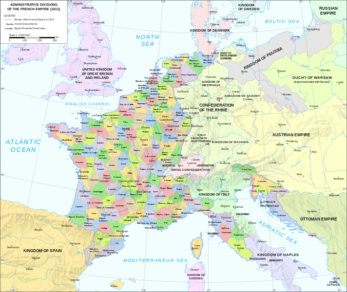
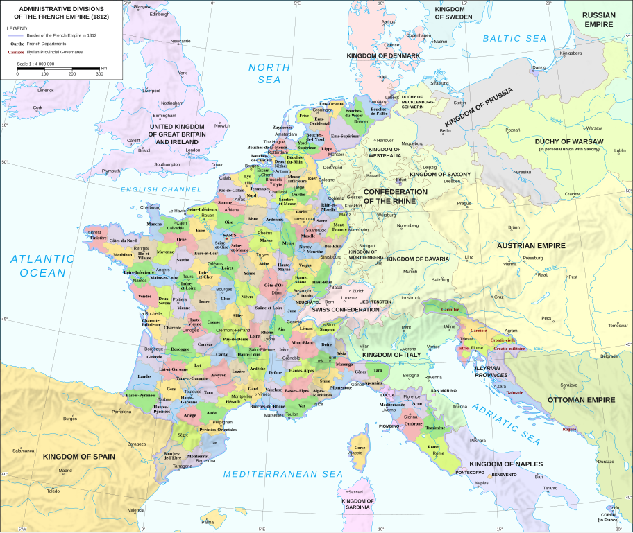
Català: Divisions administratives del Primer Imperi Francès el 1812
English: Administrative divisions of the First French Empire in 1812 |
| Datum | |
| Quelle |
|
| Urheber | Andrein |
| Andere Versionen |
Other related versions:[]
|


|
Diese SVG-Datei enthält eingebetteten Text, der mit jedem geeigneten SVG-Editor, Texteditor oder dem SVG-Übersetzungs-Werkzeug in deine Sprache übersetzt werden kann. Für mehr Informationen siehe Über das Übersetzen von SVG-Dateien. |
Diese Datei ist mit Hilfe von SVG-<switch>-Elementen übersetzt. Alle Übersetzungen sind in der selben Datei gespeichert! Mehr Informationen.
Bei den meisten Wikipedia-Projekten kannst du die Datei normal einbetten (ohne den Parameter Um diesen Text in deine Sprache zu übersetzen, kannst du das SVG-Übersetzungs-Werkzeug nutzen. Oder lade die Datei auf deinen Computer herunter, füge deine Übersetzungen mit Software ein, die du kennst, und lade sie unter dem selben Namen wieder hoch. Falls du dir nicht sicher bist, wie du vorgehen musst, erhältst du Unterstützung im Graphics Lab. |
Lizenz
- Dieses Werk darf von dir
- verbreitet werden – vervielfältigt, verbreitet und öffentlich zugänglich gemacht werden
- neu zusammengestellt werden – abgewandelt und bearbeitet werden
- Zu den folgenden Bedingungen:
- Namensnennung – Du musst angemessene Urheber- und Rechteangaben machen, einen Link zur Lizenz beifügen und angeben, ob Änderungen vorgenommen wurden. Diese Angaben dürfen in jeder angemessenen Art und Weise gemacht werden, allerdings nicht so, dass der Eindruck entsteht, der Lizenzgeber unterstütze gerade dich oder deine Nutzung besonders.
- Weitergabe unter gleichen Bedingungen – Wenn du das Material wiedermischst, transformierst oder darauf aufbaust, musst du deine Beiträge unter der gleichen oder einer kompatiblen Lizenz wie das Original verbreiten.
Dateiversionen
Klicke auf einen Zeitpunkt, um diese Version zu laden.
| Version vom | Vorschaubild | Maße | Benutzer | Kommentar | |
|---|---|---|---|---|---|
| aktuell | 18:55, 16. Jun. 2024 | | 2.052 × 1.728 (4,14 MB) | 밥풀떼기 | File uploaded using svgtranslate tool (https://svgtranslate.toolforge.org/). Added translation for ko. |
| 14:33, 9. Feb. 2024 |  | 2.052 × 1.728 (3,86 MB) | Manlleus | added catalan language | |
| 19:10, 21. Mai 2021 |  | 2.052 × 1.728 (3,55 MB) | Andrei Stroe | File uploaded using svgtranslate tool (https://svgtranslate.toolforge.org/). Added translation for ro. | |
| 14:32, 30. Aug. 2020 |  | 2.052 × 1.728 (3,24 MB) | Jfblanc | File uploaded using svgtranslate tool (https://svgtranslate.toolforge.org/). Added translation for oc. | |
| 12:37, 1. Mär. 2018 |  | 2.052 × 1.728 (2,83 MB) | Imperator Honorius | Formatting Fix | |
| 12:29, 1. Mär. 2018 |  | 2.052 × 1.728 (2,83 MB) | Imperator Honorius | Formatting and missing Anglicization (Gand to Ghent) | |
| 12:17, 1. Mär. 2018 |  | 2.052 × 1.728 (2,83 MB) | Imperator Honorius | Spelling and typos; more Anglicised (and up to date) city names. | |
| 21:41, 20. Jul. 2015 |  | 2.052 × 1.728 (2,82 MB) | ArdadN | spelling | |
| 19:11, 20. Jul. 2015 |  | 2.052 × 1.728 (2,81 MB) | ArdadN | 1 | |
| 19:05, 20. Jul. 2015 |  | 2.052 × 1.728 (2,81 MB) | ArdadN | font size |
Dateiverwendung
Keine Seiten verwenden diese Datei.
Globale Dateiverwendung
Die nachfolgenden anderen Wikis verwenden diese Datei:
- Verwendung auf af.wikipedia.org
- Verwendung auf ar.wikipedia.org
- Verwendung auf ca.wikipedia.org
- Verwendung auf en.wikipedia.org
- History of the Netherlands
- 1810s
- Departments of France
- 130 departments of the First French Empire
- Illyrian Provinces
- Kingdom of Italy (Napoleonic)
- Portal:Maps/Maps/Political
- Portal:Maps/Maps/Political/14
- First French Empire
- Bouches-del'Èbre
- Department of Segre
- Left Bank of the Rhine
- User:Dakaysaa/sandbox
- User:Falcaorib/France
- Verwendung auf et.wikipedia.org
- Verwendung auf fr.wikipedia.org
- Verwendung auf hr.wikipedia.org
- Verwendung auf it.wikipedia.org
- Verwendung auf ka.wikipedia.org
- Verwendung auf km.wikipedia.org
- Verwendung auf no.wikipedia.org
- Verwendung auf pl.wikipedia.org
- Verwendung auf pnb.wikipedia.org
- Verwendung auf pt.wikipedia.org
- Verwendung auf ru.wikipedia.org
- Verwendung auf tr.wikipedia.org
- Verwendung auf ur.wikipedia.org
- Verwendung auf vi.wikipedia.org