Datei:Italy Sardinia relief location map.svg
Zur Navigation springen
Zur Suche springen

Größe der PNG-Vorschau dieser SVG-Datei: 334 × 599 Pixel. Weitere aus SVG automatisch erzeugte PNG-Grafiken in verschiedenen Auflösungen: 134 × 240 Pixel | 267 × 480 Pixel | 428 × 768 Pixel | 571 × 1.024 Pixel | 1.142 × 2.048 Pixel | 601 × 1.078 Pixel
Originaldatei (SVG-Datei, Basisgröße: 601 × 1.078 Pixel, Dateigröße: 1,62 MB)
![]()
Diese Datei und die Informationen unter dem roten Trennstrich werden aus dem zentralen Medienarchiv Wikimedia Commons eingebunden.
![]()
Beschreibung
| Beschreibung |
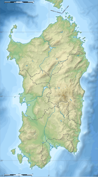
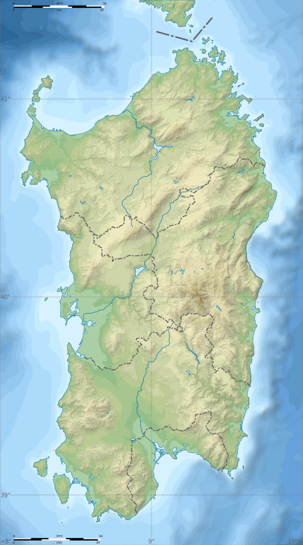
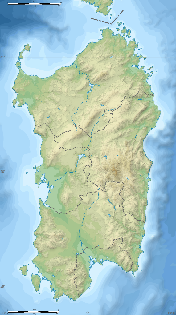
English: Blank physical map of Sardinia, Italy, for geo-location purpose, with province boundaries. Altitude levels : 25m, 50, 100, 200, 400, 600, etc. (same for bathymetry). Français : Carte topographique vierge de la Sardaigne, Italie, destinée à la géolocalisation, avec les limites des provinces. Niveaux d'altitudes : 25 m, 50, 100, 200, 400, 600, etc. Idem pour la bathymétrie.
Geographic limits of the map:
|
| Datum | (UTC) |
| Quelle |
Eigenes Werk
|
| Urheber | Sémhur |
| Andere Versionen |
Abgeleitete Werke dieser Datei: Aree protette della Sardegna.svg
|
| Namensnennung (von der Lizenz verlangt) | © Sémhur / Wikimedia Commons / |
| SVG | W3C-validity not checked. |
| Atelier graphique |

| Kameraposition | | Dieses und weitere Bilder auf OpenStreetMap |
|---|
Lizenz
Ich, der Urheberrechtsinhaber dieses Werkes, veröffentliche es hiermit unter der folgenden Lizenz:
| Copyleft: Dieses Kunstwerk ist frei, es darf weitergegeben und/oder modifiziert werden entsprechend den Bedingungen der Lizenz „Freie Kunst“.
Der vollständige Text der Lizenz steht auf der „Copyleft Attitude“-Seite sowie auf anderen Webseiten. |
Diese Datei ist unter den Creative Commons-Lizenzen Namensnennung – Weitergabe unter gleichen Bedingungen 4.0 International, 3.0 nicht portiert, 2.5 Allgemein, 2.0 Allgemein und 1.0 Allgemein lizenziert.
- Dieses Werk darf von dir
- verbreitet werden – vervielfältigt, verbreitet und öffentlich zugänglich gemacht werden
- neu zusammengestellt werden – abgewandelt und bearbeitet werden
- Zu den folgenden Bedingungen:
- Namensnennung – Du musst angemessene Urheber- und Rechteangaben machen, einen Link zur Lizenz beifügen und angeben, ob Änderungen vorgenommen wurden. Diese Angaben dürfen in jeder angemessenen Art und Weise gemacht werden, allerdings nicht so, dass der Eindruck entsteht, der Lizenzgeber unterstütze gerade dich oder deine Nutzung besonders.
- Weitergabe unter gleichen Bedingungen – Wenn du das Material wiedermischst, transformierst oder darauf aufbaust, musst du deine Beiträge unter der gleichen oder einer kompatiblen Lizenz wie das Original verbreiten.
Du darfst es unter einer der obigen Lizenzen deiner Wahl verwenden.
Dateiversionen
Klicke auf einen Zeitpunkt, um diese Version zu laden.
| Version vom | Vorschaubild | Maße | Benutzer | Kommentar | |
|---|---|---|---|---|---|
| aktuell | 17:26, 4. Mär. 2018 | | 601 × 1.078 (1,62 MB) | Ruthven | c:User:Rillke/bigChunkedUpload.js: |
| 11:29, 25. Feb. 2018 |  | 601 × 1.078 (1,62 MB) | Ruthven | New province boundaries (2016) | |
| 17:29, 24. Jan. 2010 |  | 601 × 1.078 (1,63 MB) | Sémhur | == {{int:filedesc}} == {{Information |Description= {{en|Blank physical map of Sardinia, Italy, for geo-location purpose, with province boundaries. Altitude levels : 25m, 50, 100, 200, 400, 600, etc. (same for bathymetry)}} {{fr|Carte topo |
Dateiverwendung
Die folgenden 4 Seiten verwenden diese Datei:
Globale Dateiverwendung
Die nachfolgenden anderen Wikis verwenden diese Datei:
- Verwendung auf ar.wikipedia.org
- Verwendung auf az.wikipedia.org
- Verwendung auf ba.wikipedia.org
- Verwendung auf be.wikipedia.org
- Verwendung auf bn.wikipedia.org
- Verwendung auf bs.wikipedia.org
- Verwendung auf ca.wikipedia.org
- Verwendung auf ceb.wikipedia.org
- Verwendung auf ce.wikipedia.org
- Verwendung auf cs.wikipedia.org
- Verwendung auf de.wikivoyage.org
- Verwendung auf dsb.wikipedia.org
- Verwendung auf en.wikipedia.org
- Lake Gusana
- Punta Sardegna
- Languages of Italy
- Santo Stefano (island)
- San Pietro Island
- Punta La Marmora
- Budelli
- Mechanized Brigade "Sassari"
- Lake Baratz
- 184th Paratroopers Division "Nembo"
- 203rd Coastal Division (Italy)
- 204th Coastal Division (Italy)
- 205th Coastal Division (Italy)
- Lake Coghinas
- Lake Omodeo
- Lake Liscia
- Template:Sardinia regional languages labelled map
- Module:Location map/data/Italy Sardinia/doc
- Gulf of Oristano
- User:Michael!/Project:Location map templates/Italy
- Lake Temo
- Is Molas Challenge
- Is Molas Senior Open
- Module:Location map/data/Italy Sardinia
- Module:Location map/data/Sardinia
- User:Noclador/sandbox/Royal Italian Army - Italy - September 1943
- 2019 European Ladies' Team Championship
- User:Broc/sandbox/Capo Malfatano
Weitere globale Verwendungen dieser Datei anschauen.