Datei:Map of Thera before the Minoan eruption (Druitt, Francaviglia).png
Zur Navigation springen
Zur Suche springen

Größe dieser Vorschau: 520 × 599 Pixel. Weitere Auflösungen: 208 × 240 Pixel | 417 × 480 Pixel | 667 × 768 Pixel | 1.171 × 1.349 Pixel
Originaldatei (1.171 × 1.349 Pixel, Dateigröße: 173 KB, MIME-Typ: image/png)
![]()
Diese Datei und die Informationen unter dem roten Trennstrich werden aus dem zentralen Medienarchiv Wikimedia Commons eingebunden.
![]()
.png?uselang=de)
| Beschreibung |
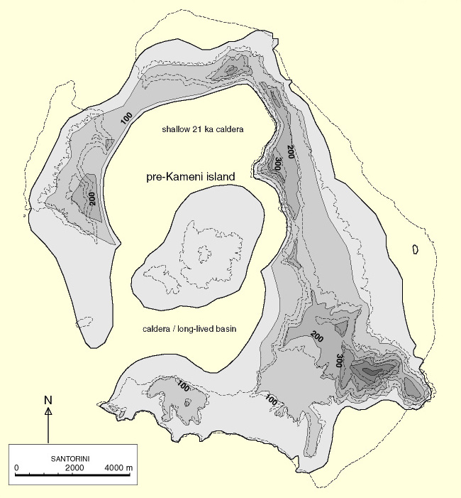
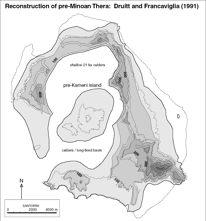
Deutsch: Karte der Insel Thera vor der Minoischen Eruption. Rekonstruktion nach Timothy H. Druitt und Vincenzo Francaviglia (1991). Die vulkanischen Küstenlinien der Mittelinsel und des nordwestlichen Rands der Caldera sind spekulativ, alle anderen Küsten bezeichnen die Autoren als „sicher“ oder „weniger sicher“.
English: Map of Thera island before the Minoan eruption |
| Datum | see file history of this file |
| Quelle |
Eigenes Werk, using
|
| Urheber | Maximilian Dörrbecker (Chumwa) |
| Genehmigung (Weiternutzung dieser Datei) |
Ich, der Urheber dieses Werkes, veröffentliche es unter der folgenden Lizenz: Diese Datei ist unter der Creative-Commons-Lizenz „Namensnennung – Weitergabe unter gleichen Bedingungen 2.5 generisch“ (US-amerikanisch) lizenziert.
Sie dürfen das Bild zu den folgenden Bedingungen nutzen:
|
| Andere Versionen | Map of Thera before the Minoan eruption.png |
Dateiversionen
Klicke auf einen Zeitpunkt, um diese Version zu laden.
| Version vom | Vorschaubild | Maße | Benutzer | Kommentar | |
|---|---|---|---|---|---|
| aktuell | 09:10, 28. Feb. 2016 | | 1.171 × 1.349 (173 KB) | Chumwa | |
| 23:57, 27. Feb. 2016 |  | 1.171 × 1.349 (172 KB) | Oltau | {{Information |Description= {{de|Karte der Insel Thera vor der Minoischen Eruption}} {{en|Map of Thera island before the Minoan eruption}} |Source={{Own}}, using * this file by {{U|FinnWikiNo}} * [[:File:Santorin.png|this f... |
Dateiverwendung
Die folgenden 2 Seiten verwenden diese Datei:
Globale Dateiverwendung
Die nachfolgenden anderen Wikis verwenden diese Datei:
- Verwendung auf et.wikipedia.org
- Verwendung auf fr.wikipedia.org
.png)