Datei:Marquette and jolliet map 1681.jpg

Originaldatei (2.056 × 860 Pixel, Dateigröße: 792 KB, MIME-Typ: image/jpeg)
![]()
Diese Datei und die Informationen unter dem roten Trennstrich werden aus dem zentralen Medienarchiv Wikimedia Commons eingebunden.
![]()
Beschreibung
| Beschreibung |
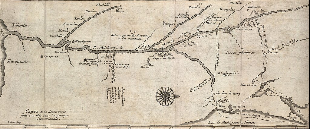
English: ca. 1681 map of the Mississippi River system, based on the 1673 expediton of Jacques Marquette and Louis Jolliet. This is one of many early maps made based on their descriptions of the interior of North America. |
||||||||||||||||||||
| Datum | |||||||||||||||||||||
| Quelle | http://hdl.loc.gov/loc.gmd/g4042m.rb000005 | ||||||||||||||||||||
| Urheber |
|
||||||||||||||||||||
| Andere Versionen |
[1] [2] |
||||||||||||||||||||

Lizenz
|
Dies ist eine originalgetreue fotografische Reproduktion eines zweidimensionalen Kunstwerks. Das Kunstwerk an sich ist aus dem folgenden Grund gemeinfrei:
Nach offizieller Ansicht der Wikimedia Foundation sind originalgetreue Reproduktionen zweidimensionaler gemeinfreier Werke gemeinfrei. Diese fotografische Reproduktion wird daher auch als gemeinfrei in den Vereinigten Staaten angesehen. Die Verwendung dieser Werke kann in anderen Rechtssystemen verboten oder nur eingeschränkt erlaubt sein. Zu Details siehe Reuse of PD-Art photographs.
| ||||
Ursprüngliches Datei-Logbuch
- 2010-04-12 18:35 Billwhittaker 860×2063× (819900 bytes) {{Information |Description = ca. 1681 map of the [[Mississippi River]] system, based on the 1673 expediton of [[Jacques Marquette]] and [[Louis Jolliet]]. This is one of many early maps made based on their descriptions of the interior of North America
Dateiversionen
Klicke auf einen Zeitpunkt, um diese Version zu laden.
| Version vom | Vorschaubild | Maße | Benutzer | Kommentar | |
|---|---|---|---|---|---|
| aktuell | 00:01, 17. Feb. 2019 | | 2.056 × 860 (792 KB) | SteinsplitterBot | Bot: Image rotated by 90° |
| 12:00, 14. Jun. 2011 |  | 860 × 2.063 (801 KB) | Urdangaray | {{Information |Description={{en|ca. 1681 map of the en:Mississippi River system, based on the 1673 expediton of en:Jacques Marquette and en:Louis Jolliet. This is one of many early maps made based on their descriptions of the interior of |
Dateiverwendung
Die folgende Seite verwendet diese Datei:
Globale Dateiverwendung
Die nachfolgenden anderen Wikis verwenden diese Datei:
- Verwendung auf ar.wikipedia.org
- Verwendung auf cs.wikipedia.org
- Verwendung auf en.wikipedia.org
- Verwendung auf es.wikipedia.org
- Verwendung auf fa.wikipedia.org
- Verwendung auf fr.wikipedia.org
- Verwendung auf hu.wikipedia.org
- Verwendung auf ja.wikipedia.org
- Verwendung auf ko.wikipedia.org
- Verwendung auf no.wikipedia.org
- Verwendung auf pl.wikipedia.org
- Verwendung auf pt.wikipedia.org
- Verwendung auf sh.wikipedia.org