Datei:Mojave Desert, Tehachapi Mountains, and San Joaquin Valley (California) – satellite image.jpg
Zur Navigation springen
Zur Suche springen

Größe dieser Vorschau: 800 × 484 Pixel. Weitere Auflösungen: 320 × 194 Pixel | 640 × 387 Pixel | 1.024 × 619 Pixel | 1.280 × 774 Pixel | 2.560 × 1.548 Pixel | 8.824 × 5.336 Pixel
Originaldatei (8.824 × 5.336 Pixel, Dateigröße: 13,03 MB, MIME-Typ: image/jpeg)
![]()
Diese Datei und die Informationen unter dem roten Trennstrich werden aus dem zentralen Medienarchiv Wikimedia Commons eingebunden.
![]()
Beschreibung
| Beschreibung |
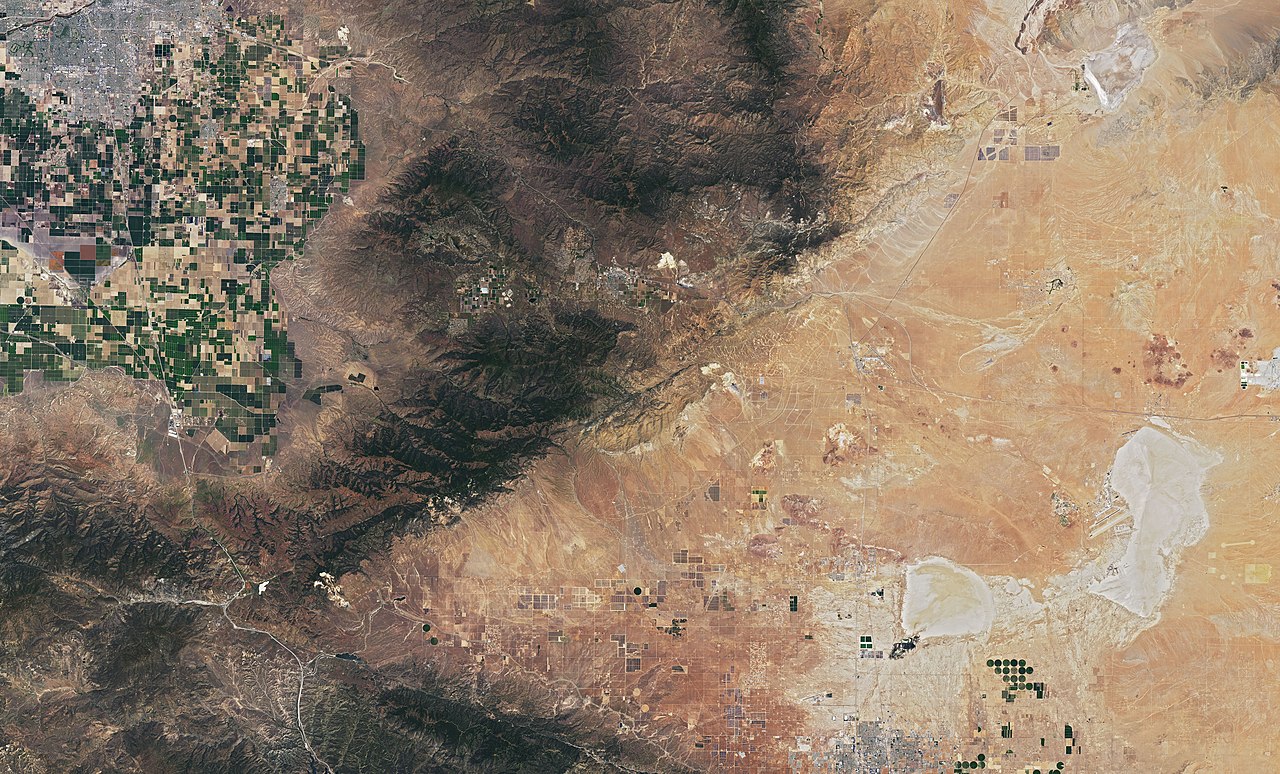
English: Satellite image of Mojave Desert (right), Tehachapi Mountains (Transverse Ranges) (center) and the southermost part of San Joaquin Valley (top left) in California. Mostly Kern County, the southermost part Los Angeles County.
On July 1, 2019, Operational Land Imager (OLI) on NASA's Landsat 8 acquired this image. Well visible landmarks: Bakersfield and the farmlands of San Joaquin Valley (top left). Tehachapi Pass (center). To the right of it, a massive amount of wind turbines (mostly Alta Wind Energy Center, one of the biggest wind farms in the world), which are connected by both straight and sinuous access roads. Rogers Dry Lake (bottom right) with Edwards Air Force Base, where the first Space Shuttle landed (then back-up landing site to Kennedy Space Center, Florida). |
| Datum | |
| Quelle | https://earthobservatory.nasa.gov/images/145607/cameron-ridge?src=ve |
| Urheber | NASA |
_%E2%80%93_satellite_image.jpg)

,_California_%E2%80%93_satellite_image.jpg)


_%E2%80%93_satellite_image.jpg?uselang=de)
,_California_%E2%80%93_satellite_image.jpg)
_California_%E2%80%93_labeled_satellite_image.png)
Lizenz
| Diese Datei ist gemeinfrei (public domain), da sie von der NASA erstellt worden ist. Die NASA-Urheberrechtsrichtlinie besagt, dass „NASA-Material nicht durch Urheberrecht geschützt ist, wenn es nicht anders angegeben ist“. (NASA-Urheberrechtsrichtlinie-Seite oder JPL Image Use Policy). | ||
 |
Warnung:
|
Dateiversionen
Klicke auf einen Zeitpunkt, um diese Version zu laden.
| Version vom | Vorschaubild | Maße | Benutzer | Kommentar | |
|---|---|---|---|---|---|
| aktuell | 23:08, 12. Okt. 2019 | | 8.824 × 5.336 (13,03 MB) | A11w1ss3nd | {{Information |description ={{en|1=Satellite image of Mojave Desert (right), Tehachapi Mountains (Transverse Ranges) (center) and the southermost part of San Joaquin Valley (top left) in California. Mostly Kern County, the southermost part Los Angeles County. On July 1, 2019, Operational Land Imager (OLI) on NASA's Landsat 8 acquired this image. Well visible landmarks: Bakersfield and the farmlands of San Joaquin Valley (top left). Tehachapi Pass (center). To the right of it, a massive... |
Dateiverwendung
Keine Seiten verwenden diese Datei.
_–_satellite_image.jpg)