Datei:PL Dolna Wisła.png
Zur Navigation springen
Zur Suche springen

Größe dieser Vorschau: 375 × 599 Pixel. Weitere Auflösungen: 150 × 240 Pixel | 301 × 480 Pixel | 1.000 × 1.596 Pixel
Originaldatei (1.000 × 1.596 Pixel, Dateigröße: 2,1 MB, MIME-Typ: image/png)
![]()
Diese Datei und die Informationen unter dem roten Trennstrich werden aus dem zentralen Medienarchiv Wikimedia Commons eingebunden.
![]()
Beschreibung
| Beschreibung |
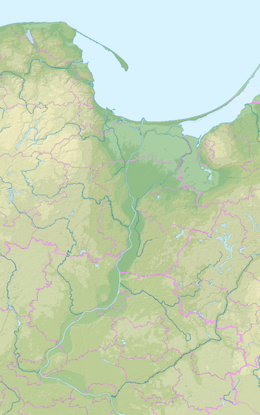
Relief location map of the region around lower Vistula from the Chełmno Land to Hel peninsula. Extension: 52.907°N to 54.94°N, 17.904°E to 19.86°E. |
| Datum | |
| Quelle | File:Pomeranian Voivodeship Relief location map.svg File:Pomeranian Voivodeship Relief location map.svg, File:Kuyavian-Pomeranian Voivodeship Relief location map.svg |
| Urheber | Ulamm (Diskussion) |
Lizenz
Ich, der Urheber dieses Werkes, veröffentliche es unter der folgenden Lizenz:
Diese Datei ist lizenziert unter der Creative-Commons-Lizenz „Namensnennung – Weitergabe unter gleichen Bedingungen 4.0 international“.
- Dieses Werk darf von dir
- verbreitet werden – vervielfältigt, verbreitet und öffentlich zugänglich gemacht werden
- neu zusammengestellt werden – abgewandelt und bearbeitet werden
- Zu den folgenden Bedingungen:
- Namensnennung – Du musst angemessene Urheber- und Rechteangaben machen, einen Link zur Lizenz beifügen und angeben, ob Änderungen vorgenommen wurden. Diese Angaben dürfen in jeder angemessenen Art und Weise gemacht werden, allerdings nicht so, dass der Eindruck entsteht, der Lizenzgeber unterstütze gerade dich oder deine Nutzung besonders.
- Weitergabe unter gleichen Bedingungen – Wenn du das Material wiedermischst, transformierst oder darauf aufbaust, musst du deine Beiträge unter der gleichen oder einer kompatiblen Lizenz wie das Original verbreiten.
Dateiversionen
Klicke auf einen Zeitpunkt, um diese Version zu laden.
| Version vom | Vorschaubild | Maße | Benutzer | Kommentar | |
|---|---|---|---|---|---|
| aktuell | 23:18, 1. Mär. 2020 | | 1.000 × 1.596 (2,1 MB) | Ulamm | completed |
| 22:56, 1. Mär. 2020 |  | 1.000 × 1.596 (2,1 MB) | Ulamm | completed | |
| 14:53, 1. Mär. 2020 |  | 1.000 × 1.596 (2,12 MB) | Ulamm | {{Information |Description=Relief location map of the region around lower Vistula from the Chełmno Land to Hel peninsula.<br/>Extension: 52.907°N to 54.94°N, 17.904°E to 19.86°E. |Source=File:Pomeranian Voivodeship Relief location map.svg File:Pomeranian Voivodeship Relief location map.svg, File:Kuyavian-Pomeranian Voivodeship Relief location map.svg |Date=2020-03-01 |Author=~~~ |Permission= |other_versions= }} Category:Maps by Ulamm Category:Location maps of Poland |
Dateiverwendung
Die folgenden 2 Seiten verwenden diese Datei: