Datei:Paneuropetransport.png
Zur Navigation springen
Zur Suche springen

Größe dieser Vorschau: 492 × 600 Pixel. Weitere Auflösungen: 197 × 240 Pixel | 394 × 480 Pixel | 773 × 942 Pixel
Originaldatei (773 × 942 Pixel, Dateigröße: 32 KB, MIME-Typ: image/png)
![]()
Diese Datei und die Informationen unter dem roten Trennstrich werden aus dem zentralen Medienarchiv Wikimedia Commons eingebunden.
![]()
Beschreibung

|
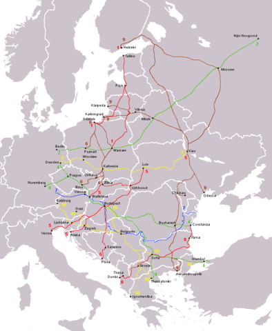
File:Pan-European corridors.svg ist eine vektorisierte Version dieses Bildes. Diese sollte an Stelle des Rasterbildes verwendet werden, sofern sie nicht schlechter ist.
File:Paneuropetransport.png → File:Pan-European corridors.svg
Für weitere Informationen siehe Help:SVG. |
 |
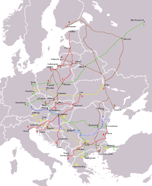
The ten Pan-European transport corridors.
Created by User:Albinfo using User:wiki-vr's blank map.
derivative works
Abgeleitete Werke dieser Datei: Pan-European corridors.svg
Lizenz
| Ich, der Urheberrechtsinhaber dieses Werkes, veröffentliche es als gemeinfrei. Dies gilt weltweit. In manchen Staaten könnte dies rechtlich nicht möglich sein. Sofern dies der Fall ist: Ich gewähre jedem das bedingungslose Recht, dieses Werk für jedweden Zweck zu nutzen, es sei denn, Bedingungen sind gesetzlich erforderlich. |
Dateiversionen
Klicke auf einen Zeitpunkt, um diese Version zu laden.
| Version vom | Vorschaubild | Maße | Benutzer | Kommentar | |
|---|---|---|---|---|---|
| aktuell | 15:15, 14. Aug. 2013 | | 773 × 942 (32 KB) | Spiridon Ion Cepleanu | Little rectifications around low-Danube |
| 10:05, 18. Okt. 2007 |  | 773 × 942 (44 KB) | Hoshie | added Montenegro. Under same lic. as before. | |
| 01:11, 13. Dez. 2006 |  | 773 × 942 (37 KB) | Albinfo | Fixed several errors and updated corrections in the original file - sorry for all the misleadings | |
| 22:06, 5. Dez. 2006 |  | 773 × 941 (33 KB) | Geo-Loge~commonswiki | Ostrava => Brno, Ostrava added, Wroclaw and Krakow added | |
| 19:12, 24. Jun. 2006 |  | 773 × 941 (28 KB) | Joy | Fixed confusion between Lviv and Uzhorod. | |
| 00:42, 31. Dez. 2005 |  | 773 × 941 (36 KB) | Albinfo | The ten Pan-European transport corridors. Created by User:Albinfo using User:wiki-vr's blank map. |
Dateiverwendung
Die folgende Seite verwendet diese Datei:
Globale Dateiverwendung
Die nachfolgenden anderen Wikis verwenden diese Datei:
- Verwendung auf be.wikipedia.org
- Verwendung auf cs.wikipedia.org
- Verwendung auf eo.wikipedia.org
- Verwendung auf es.wikipedia.org
- Verwendung auf fr.wikipedia.org
- Verwendung auf sr.wikipedia.org
- Verwendung auf sv.wikipedia.org