Datei:Puget Lowland basins and faults.png
Zur Navigation springen
Zur Suche springen
Es ist keine höhere Auflösung vorhanden.
Puget_Lowland_basins_and_faults.png (358 × 546 Pixel, Dateigröße: 1.012 KB, MIME-Typ: image/png)
![]()
Diese Datei und die Informationen unter dem roten Trennstrich werden aus dem zentralen Medienarchiv Wikimedia Commons eingebunden.
![]()
| Beschreibung |
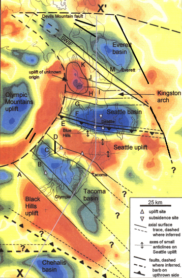
English: Bouguer gravity anomaly map of the Puget Lowland region (WA) and principal faults and folds, over outline of Puget Sound, Hood Canal, and east end of Strait of Juan de Fuca. Blue and green generally indicate basins (with lower density sedimentary rock), red is generally uplifted basalt of the Crescent Formation. White triangles indicate locations determined to have been uplifted/subsided by earthquake about 1100 years ago.
Modified from plate 1 of Pratt, et al., "Seismic reflection images beneath Puget Sound, western Washington State: The Puget Lowland thrust sheet hypothesis" Journal of Geophysical Research 102(B12):27,469—27,489 (Dec. 10, 1997) doi: 10.1029/97JB01830 |
|||
| Datum | etwa 1997 | |||
| Quelle | http://faculty.washington.edu/tpratt/JGR97.pdf | |||
| Urheber | Thomas Pratt et al. (all USGS staff) | |||
| Genehmigung (Weiternutzung dieser Datei) |
|
Dateiversionen
Klicke auf einen Zeitpunkt, um diese Version zu laden.
| Version vom | Vorschaubild | Maße | Benutzer | Kommentar | |
|---|---|---|---|---|---|
| aktuell | 00:21, 16. Okt. 2017 | | 358 × 546 (1.012 KB) | J. Johnson | Added RMFZ and GFFZ (Rogers Belt), to reflect new knowledge in the last ten years. |
| 23:50, 27. Mai 2010 |  | 358 × 546 (1.012 KB) | J. Johnson | {{Information |Description={{en|1=Bouguer gravity anomaly map of the Puget Lowland region (WA) and principal faults and folds, over outline of Puget Sound, Hood Canal, and east end of Strait of Juan de Fuca. Blue and green generally indicate basins (with |
Dateiverwendung
Die folgende Seite verwendet diese Datei:
Globale Dateiverwendung
Die nachfolgenden anderen Wikis verwenden diese Datei:
- Verwendung auf en.wikipedia.org