Datei:070727 New Washington ADIZ-FRZ.jpg
Zur Navigation springen
Zur Suche springen
Größe dieser Vorschau: 780 × 600 Pixel. Weitere Auflösungen: 312 × 240 Pixel | 624 × 480 Pixel | 900 × 692 Pixel
Originaldatei (900 × 692 Pixel, Dateigröße: 220 KB, MIME-Typ: image/jpeg)
![]()
Diese Datei und die Informationen unter dem roten Trennstrich werden aus dem zentralen Medienarchiv Wikimedia Commons eingebunden.
![]()
Beschreibung
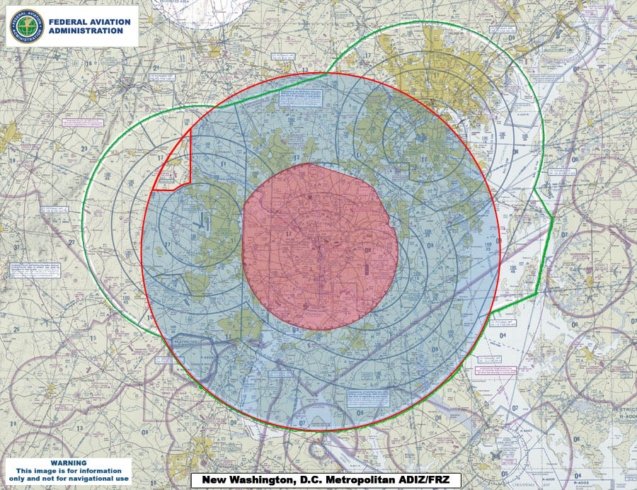
| Beschreibung | This map compares the new Air Defense Identification Zone (ADIZ) surrounding Washington, D.C. (red line) with the old ADIZ (green line). The new zone is effective as of 0500 UTC, 30 Aug 2007. The shaded red circle in the middle is the restricted airspace surrounding the capital. |
| Datum | |
| Quelle | U.S. Federal Aviation Administration (http://www.faa.gov) - http://www.faa.gov/news/updates/adiz_frz/media/070727_New_ADIZ-FRZ.jpg |
| Urheber | U.S. Federal Aviation Administration |
Lizenz
This image or file is a work of a Federal Aviation Administration employee, taken or made as part of that person's official duties. As a work of the U.S. federal government, the image is in the public domain in the United States.
|
 |
Dateiversionen
Klicke auf einen Zeitpunkt, um diese Version zu laden.
| Version vom | Vorschaubild | Maße | Benutzer | Kommentar | |
|---|---|---|---|---|---|
| aktuell | 02:09, 31. Jul. 2007 | | 900 × 692 (220 KB) | Sarfa~commonswiki | This map compares the new Air Defense Identification Zone (ADIZ) surrounding Washington, D.C. (red line) with the old ADIZ (green line). The new zone is effective as of 0500 UTC, 30 Aug 2007. |
Dateiverwendung
Die folgende Seite verwendet diese Datei:
Globale Dateiverwendung
Die nachfolgenden anderen Wikis verwenden diese Datei:
- Verwendung auf en.wikipedia.org
- Verwendung auf fi.wikipedia.org
- Verwendung auf it.wikipedia.org
- Verwendung auf ja.wikipedia.org
- Verwendung auf ko.wikipedia.org
- Verwendung auf www.wikidata.org
- Verwendung auf zh.wikipedia.org