Datei:2010 Eruption at Mount Merapi, Indonesia.jpg
Zur Navigation springen
Zur Suche springen

Größe dieser Vorschau: 681 × 599 Pixel. Weitere Auflösungen: 273 × 240 Pixel | 545 × 480 Pixel | 873 × 768 Pixel | 1.164 × 1.024 Pixel | 2.327 × 2.048 Pixel | 2.770 × 2.438 Pixel
Originaldatei (2.770 × 2.438 Pixel, Dateigröße: 1,57 MB, MIME-Typ: image/jpeg)
![]()
Diese Datei und die Informationen unter dem roten Trennstrich werden aus dem zentralen Medienarchiv Wikimedia Commons eingebunden.
![]()
Beschreibung
| Beschreibung |
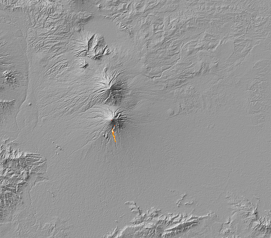
English: The thermal signature of hot ash and rock and a glowing lava dome on Mount Merapi. The thermal data is overlaid on a three-dimensional map of the volcano in this image to show the approximate location of the flow. The Center of Volcanology and Geological Hazard Mitigation reported that two pyroclastic flows moved down the volcano on October 30, 2010. A pyroclastic flow is an avalanche of extremely hot gas, ash, and rock that tears down the side of a volcano at high speeds. |
| Datum | |
| Quelle | NASA Earth Observatory |
| Urheber | Robert Simmon and Jesse Allen |
Image captured by the Advanced Spaceborne Thermal Emission and Reflection Radiometer (ASTER) on NASA’s Terra satellite.
Lizenz
| Diese Datei ist gemeinfrei (public domain), da sie von der NASA erstellt worden ist. Die NASA-Urheberrechtsrichtlinie besagt, dass „NASA-Material nicht durch Urheberrecht geschützt ist, wenn es nicht anders angegeben ist“. (NASA-Urheberrechtsrichtlinie-Seite oder JPL Image Use Policy). | ||
 |
Warnung:
|
| Bildnotizen | Diese Datei ist annotiert: Betrachte diese auf Commons. |
Dateiversionen
Klicke auf einen Zeitpunkt, um diese Version zu laden.
| Version vom | Vorschaubild | Maße | Benutzer | Kommentar | |
|---|---|---|---|---|---|
| aktuell | 14:03, 5. Nov. 2010 | | 2.770 × 2.438 (1,57 MB) | Originalwana | {{Information |Description={{en|1=The thermal signature of hot ash and rock and a glowing lava dome on Mount Merapi. The thermal data is overlaid on a three-dimensional map of the volcano in this image to show the approximate location of the flow. Th |
Dateiverwendung
Die folgende Seite verwendet diese Datei:
Globale Dateiverwendung
Die nachfolgenden anderen Wikis verwenden diese Datei:
- Verwendung auf en.wikipedia.org
- Verwendung auf fr.wikipedia.org