Datei:Amazon River ESA387332.jpg

Originaldatei (1.920 × 1.920 Pixel, Dateigröße: 5,23 MB, MIME-Typ: image/jpeg)
![]()
Diese Datei und die Informationen unter dem roten Trennstrich werden aus dem zentralen Medienarchiv Wikimedia Commons eingebunden.
Beschreibung
| BeschreibungAmazon River ESA387332.jpg |
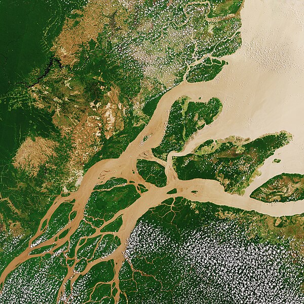
English: The Copernicus Sentinel-2A satellite takes us over northern Brazil on 22 August 2017, where the Amazon River meets the Atlantic Ocean (Amazon Delta).
Click on the "media-viewer button" (and +) to view this image at its full 10 m resolution directly in your browser. The sediment-laden water appears brown as it flows from the lower left to the open ocean in the upper right. ‘Popcorn’ clouds (Cumulus humilis clouds) are visible in parts of the image – a common occurrence during the Amazon’s dry season, formed by condensed water vapour released by plants and trees during the sunny day. The land varies in colour from the deep green of dense vegetation to light brown. Taking a closer look to the upper-left section of the image, we can see large brown areas where the vegetation has already been cleared away. Geometric shapes indicate agricultural fields, and linear roads cut through the remaining dense vegetation. Rainforests worldwide are being destroyed at an alarming rate. This is of great concern because they play an important role in global climate, and are home to a wide variety of plants, animals and insects. More than a third of all species in the world live in the Amazon Rainforest. Unlike other forests, rainforests have difficulty regrowing after they are destroyed and, owing to their composition, their soils are not suitable for long-term agricultural use. With their unique view from space, Earth observation satellites have been instrumental in highlighting the vulnerability of the rainforests by documenting the scale of deforestation. This image is featured on theEarth from Space video programme. |
| Datum | Aufgenommen am 22. August 2017 |
| Quelle | http://www.esa.int/spaceinimages/Images/2017/12/Amazon_River |
| Urheber | European Space Agency |
| Genehmigung (Weiternutzung dieser Datei) |
contains modified Copernicus Sentinel data (2017), processed by ESA,CC BY-SA 3.0 IGO |
| Andere Versionen |
|
| Title InfoField | Amazon River |
| Set InfoField | Earth observation image of the week |
| System InfoField | Copernicus |
| Mission InfoField | Sentinel-2 |
| Location InfoField | Amazon Rainforest |
| Activity InfoField | Observing the Earth |
| Keywords InfoField | Rainforest |
| Zu dieser Datei existiert ein Bildausschnitt: Imagem de Satélite Ilha Caviana.jpg. |
Lizenz
This media was created by the European Space Agency (ESA).
Where expressly so stated, images or videos are covered by the Creative Commons Attribution-ShareAlike 3.0 IGO (CC BY-SA 3.0 IGO) licence, ESA being an Intergovernmental Organisation (IGO), as defined by the CC BY-SA 3.0 IGO licence. The user is allowed under the terms and conditions of the CC BY-SA 3.0 IGO license to Reproduce, Distribute and Publicly Perform the ESA images and videos released under CC BY-SA 3.0 IGO licence and the Adaptations thereof, without further explicit permission being necessary, for as long as the user complies with the conditions and restrictions set forth in the CC BY-SA 3.0 IGO licence, these including that:
See the ESA Creative Commons copyright notice for complete information, and this article for additional details.
|
 | |
Diese Datei ist lizenziert unter der Creative-Commons-Lizenz „Namensnennung – Weitergabe unter gleichen Bedingungen 3.0 IGO“. Namensnennung: ESA, CC BY-SA IGO 3.0
| ||

|
This image contains data from a satellite in the Copernicus Programme, such as Sentinel-1, Sentinel-2 or Sentinel-3. Attribution is required when using this image.
Namensnennung: Contains modified Copernicus Sentinel data 2017
Attribution
The use of Copernicus Sentinel Data is regulated under EU law (Commission Delegated Regulation (EU) No 1159/2013 and Regulation (EU) No 377/2014). Relevant excerpts:
Free access shall be given to GMES dedicated data [...] made available through GMES dissemination platforms [...].
Access to GMES dedicated data [...] shall be given for the purpose of the following use in so far as it is lawful:
GMES dedicated data [...] may be used worldwide without limitations in time.
GMES dedicated data and GMES service information are provided to users without any express or implied warranty, including as regards quality and suitability for any purpose. |
Attribution
Kurzbeschreibungen
In dieser Datei abgebildete Objekte
Motiv
22. August 2017
image/jpeg
8f96c95837dac3fc1daa5c3b6106e82fefc35067
5.486.145 Byte
1.920 Pixel
1.920 Pixel
Dateiversionen
Klicke auf einen Zeitpunkt, um diese Version zu laden.
| Version vom | Vorschaubild | Maße | Benutzer | Kommentar | |
|---|---|---|---|---|---|
| aktuell | 18:57, 1. Dez. 2017 |  | 1.920 × 1.920 (5,23 MB) | Fæ | European Space Agency, Id 387332, http://www.esa.int/spaceinimages/Images/2017/12/Amazon_River, User:Fæ/Project_list/ESA |
Dateiverwendung
Die folgenden 2 Seiten verwenden diese Datei:
Globale Dateiverwendung
Die nachfolgenden anderen Wikis verwenden diese Datei:
- Verwendung auf als.wikipedia.org
- Verwendung auf bg.wikipedia.org
- Verwendung auf en.wikipedia.org
- Verwendung auf incubator.wikimedia.org
- Verwendung auf pt.wikipedia.org
- Verwendung auf vi.wikipedia.org
- Verwendung auf www.wikidata.org
Metadaten
Diese Datei enthält weitere Informationen (beispielsweise Exif-Metadaten), die in der Regel von der Digitalkamera oder dem verwendeten Scanner stammen. Durch nachträgliche Bearbeitung der Originaldatei können einige Details verändert worden sein.
| Breite | 24.569 px |
|---|---|
| Höhe | 24.570 px |
| Bits pro Farbkomponente |
|
| Art der Kompression | Unkomprimiert |
| Pixelzusammensetzung | RGB |
| Kameraausrichtung | Normal |
| Anzahl Komponenten | 3 |
| Horizontale Auflösung | 72 dpi |
| Vertikale Auflösung | 72 dpi |
| Datenausrichtung | Grobformat |
| Software | Adobe Photoshop CC (Macintosh) |
| Speicherzeitpunkt | 10:45, 30. Nov. 2017 |
| Farbraum | Nicht kalibriert |
| Digitalisierungszeitpunkt | 10:28, 20. Sep. 2017 |
| Datum, zu dem die Metadaten letztmalig geändert wurden | 11:45, 30. Nov. 2017 |
| Eindeutige Kennung des ursprünglichen Dokuments | xmp.did:9fcf1a83-ae84-5948-825a-1e661eeacf92 |


