Datei:BlankMap-World-Flattened.svg
Zur Navigation springen
Zur Suche springen

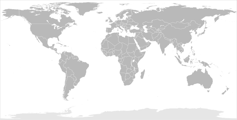
Größe der PNG-Vorschau dieser SVG-Datei: 800 × 406 Pixel. Weitere aus SVG automatisch erzeugte PNG-Grafiken in verschiedenen Auflösungen: 320 × 162 Pixel | 640 × 325 Pixel | 1.024 × 519 Pixel | 1.280 × 649 Pixel | 2.560 × 1.299 Pixel | 2.754 × 1.397 Pixel
Originaldatei (SVG-Datei, Basisgröße: 2.754 × 1.397 Pixel, Dateigröße: 1,68 MB)
![]()
Diese Datei und die Informationen unter dem roten Trennstrich werden aus dem zentralen Medienarchiv Wikimedia Commons eingebunden.
![]()
Beschreibung
| Beschreibung |
English: Blank political map of the world in modified (flattened) Robinson projection. This image is a sample of output from nugsl-worldmap, a Python script for the manipulation of this map. The script can also produce rotated images, add pinpoint marks at particular geographic coordinates, and produce web pages with clickable areas for specific countries and pinpoint marks.
Note that this map is not equirectangular, and cannot be used as a push-pin map to identify coordinates assuming equal latitude and longitude spacing. A map using the equirectangular projection is available at File:BlankMap-World6-Equirectangular.svg. |
| Datum | (for the script only) |
| Quelle |
http://www.law.nagoya-u.ac.jp/en/appendix/software/worldmap/ Refactored from Image:BlankMap-World.svg, q.v. |
| Urheber | Frank Bennett |
| Genehmigung (Weiternutzung dieser Datei) |
The map data manipulated by the script is in the public domain. The raw output of the script, including the file shown here, is also in the public domain. |
| Andere Versionen |
Abgeleitete Werke dieser Datei:
|
| SVG‑Erstellung |
Lizenz
| Ich, der Urheberrechtsinhaber dieses Werkes, veröffentliche es als gemeinfrei. Dies gilt weltweit. In manchen Staaten könnte dies rechtlich nicht möglich sein. Sofern dies der Fall ist: Ich gewähre jedem das bedingungslose Recht, dieses Werk für jedweden Zweck zu nutzen, es sei denn, Bedingungen sind gesetzlich erforderlich. |
Dateiversionen
Klicke auf einen Zeitpunkt, um diese Version zu laden.
| Version vom | Vorschaubild | Maße | Benutzer | Kommentar | |
|---|---|---|---|---|---|
| aktuell | 12:44, 20. Mär. 2014 | | 2.754 × 1.397 (1,68 MB) | Underlying lk | fix classes for Soudan and South Soudan |
| 18:01, 16. Mär. 2013 |  | 2.754 × 1.397 (1,68 MB) | Flappiefh | South Sudan added. | |
| 13:47, 14. Jan. 2008 |  | 2.754 × 1.397 (1,67 MB) | Biercenator | Updated to current version of map produced by the script. | |
| 15:22, 19. Dez. 2007 |  | 940 × 477 (1,99 MB) | Biercenator | == Summary == Refactored from en:Image:BlankMap-World6.svg, q.v. This image is a sample of output from [http://gsl-nagoya-u.net/appendix/software/worldmap/ nugsl-worldmap], a Python script for the manipulation and maintenance of this map. The flatt | |
| 17:31, 15. Dez. 2007 |  | 940 × 477 (2 MB) | Biercenator | Refactored from en:Image:BlankMap-World6.svg, q.v. This image might prove useful if you want to change the area shown in the center of the Robinson projection version, since the conversion can be reversed. | |
| 17:18, 15. Dez. 2007 |  | 940 × 477 (2 MB) | Biercenator | == Summary == Refactored from en:BlankMap-World6.svg, q.v. This image might prove useful if you want to area shown in the center of the Robinson projection version, since the conversion can be reversed. |
Dateiverwendung
Die folgenden 2 Seiten verwenden diese Datei:
Globale Dateiverwendung
Die nachfolgenden anderen Wikis verwenden diese Datei:
- Verwendung auf ca.wikipedia.org
- Verwendung auf en.wikipedia.org
- Verwendung auf es.wikipedia.org
- Verwendung auf fr.wikipedia.org
- Verwendung auf he.wikipedia.org