Datei:Boston, Massachusetts 1955 Yellow Book.jpg
Boston,_Massachusetts_1955_Yellow_Book.jpg (800 × 476 Pixel, Dateigröße: 91 KB, MIME-Typ: image/jpeg)
![]()
Diese Datei und die Informationen unter dem roten Trennstrich werden aus dem zentralen Medienarchiv Wikimedia Commons eingebunden.
![]()
| Beschreibung |
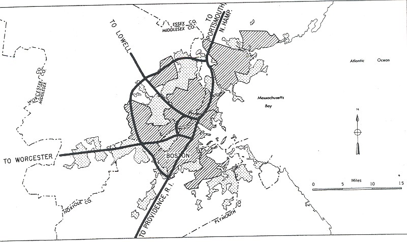
English: City of Boston, Massachusetts from the 1955 "Yellow Book" of Interstate Highway System plans. These roughly correspond to modern I-90 (to Worcester), I-95/MA-128 (outer loop), MA-3 (to Lowell; never built inside 95), and I-93 (northern expressway inside I-95), plus the never-built I-695 inner loop and I-95 southwest expressway. |
|||
| Datum | ||||
| Quelle |
|
|||
| Urheber | Public Roads Administration - Federal Works Agency (predecessor to the United States Department of Transportation). | |||
| Genehmigung (Weiternutzung dieser Datei) |
|


Dateiversionen
Klicke auf einen Zeitpunkt, um diese Version zu laden.
| Version vom | Vorschaubild | Maße | Benutzer | Kommentar | |
|---|---|---|---|---|---|
| aktuell | 11:12, 25. Dez. 2005 | | 800 × 476 (91 KB) | SPUI~commonswiki | {{PD-USGov}} City map from the 1955 "Yellow Book" of Interstate Highway System plans, from [http://www.ajfroggie.com/roads/yellowbook/]. Category:1955 Yellow Book maps |
Dateiverwendung
Die folgende Seite verwendet diese Datei:
Globale Dateiverwendung
Die nachfolgenden anderen Wikis verwenden diese Datei:
- Verwendung auf en.wikipedia.org
- Verwendung auf en.wikisource.org
- Verwendung auf fr.wikipedia.org
- Verwendung auf www.wikidata.org