Datei:Connecticut River Map.png
Zur Navigation springen
Zur Suche springen
Größe dieser Vorschau: 448 × 600 Pixel. Weitere Auflösungen: 179 × 240 Pixel | 578 × 774 Pixel
Originaldatei (578 × 774 Pixel, Dateigröße: 58 KB, MIME-Typ: image/png)
![]()
Diese Datei und die Informationen unter dem roten Trennstrich werden aus dem zentralen Medienarchiv Wikimedia Commons eingebunden.
![]()
Beschreibung
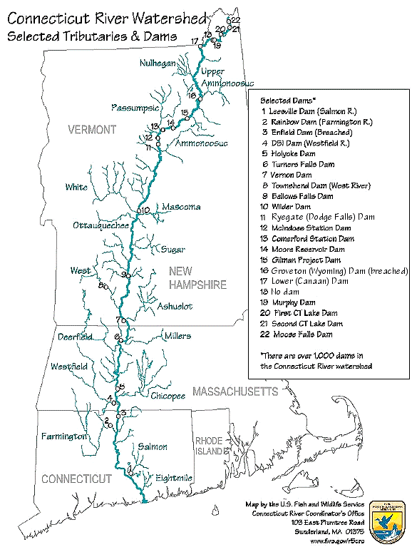
| Beschreibung | Map of the Connecticut River, New England, USA. This map was prepared by the United States Fish and Wildlife Service, and as a product of the United States Government is in the public domain and not subject to copyright restrictions. | |||
| Quelle | Originally from en.wikipedia; description page is/was here. Original uploader was Daderot in der Wikipedia auf Englisch | |||
| Urheber | USGov | |||
| Genehmigung (Weiternutzung dieser Datei) |
|


|
Dieses Bild des Typs Transport map sollte als Vektorgrafik im SVG-Format neu erstellt werden. Vektorformate haben zahlreiche Vorteile; weitere Information unter Commons:Media for cleanup. Wenn dir eine SVG-Version dieses Bildes vorliegt, so lade diese bitte hoch. Nach dem Hochladen der Datei ist diese Vorlage auf der aktuellen Bildbeschreibungsseite durch die Vorlage {{Vector version available}}, oder kürzer {{Vva}}, zu ersetzen. Es ist empfohlen die neue SVG-Datei „Connecticut River Map.svg“ zu nennen – dann benötigt die Vorlage vector version available (bzw. vva) keinen Parameter.
|
Ursprüngliches Datei-Logbuch
| Version vom | Maße | Benutzer | Kommentar |
|---|---|---|---|
| 6. Januar 2008, 16:02:00 | 580 × 778 (61343 bytes) | Gridge (Diskussion · Beiträge) | {{Information |Description=Map of the Connecticut River, New England, USA. This map was prepared by the United States Fish and Wildlife Service, and as a product of the United States Government is in the public domain and not subject to copyright restrict |
Dateiversionen
Klicke auf einen Zeitpunkt, um diese Version zu laden.
| Version vom | Vorschaubild | Maße | Benutzer | Kommentar | |
|---|---|---|---|---|---|
| aktuell | 10:26, 10. Mär. 2024 | | 578 × 774 (58 KB) | Lojwe | Cropped < 1 % horizontally, 1 % vertically using CropTool with precise mode. |
| 06:45, 25. Nov. 2014 |  | 580 × 778 (74 KB) | GifTagger | Bot: Converting file to superior PNG file. (Source: Connecticut_River_Map.gif). This GIF was problematic due to non-greyscale color table. |
Dateiverwendung
Die folgende Seite verwendet diese Datei:
Globale Dateiverwendung
Die nachfolgenden anderen Wikis verwenden diese Datei:
- Verwendung auf bg.wikipedia.org
- Verwendung auf cs.wikipedia.org
- Verwendung auf da.wikipedia.org
- Verwendung auf en.wikipedia.org
- Verwendung auf es.wikipedia.org
- Verwendung auf fi.wikipedia.org
- Verwendung auf fr.wikipedia.org
- Verwendung auf fy.wikipedia.org
- Verwendung auf he.wikipedia.org
- Verwendung auf incubator.wikimedia.org
- Verwendung auf it.wikipedia.org
- Verwendung auf ja.wikipedia.org
- Verwendung auf nl.wikipedia.org
- Verwendung auf pt.wikipedia.org
- Verwendung auf ru.wikipedia.org
- Verwendung auf simple.wikipedia.org
- Verwendung auf sv.wikipedia.org
- Verwendung auf sw.wikipedia.org
- Verwendung auf ta.wikipedia.org
- Verwendung auf th.wikipedia.org
- Verwendung auf www.wikidata.org
- Verwendung auf zh.wikipedia.org