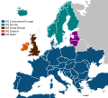
Datei:ElectricityUCTE.svg
Zur Navigation springen
Zur Suche springen

Größe der PNG-Vorschau dieser SVG-Datei: 621 × 600 Pixel. Weitere aus SVG automatisch erzeugte PNG-Grafiken in verschiedenen Auflösungen: 249 × 240 Pixel | 497 × 480 Pixel | 795 × 768 Pixel | 1.061 × 1.024 Pixel | 2.121 × 2.048 Pixel | 1.450 × 1.400 Pixel
Originaldatei (SVG-Datei, Basisgröße: 1.450 × 1.400 Pixel, Dateigröße: 353 KB)
Dateiversionen
Klicke auf einen Zeitpunkt, um diese Version zu laden.
| Version vom | Vorschaubild | Maße | Benutzer | Kommentar | |
|---|---|---|---|---|---|
| aktuell | 18:07, 10. Dez. 2022 |  | 1.450 × 1.400 (353 KB) | Iktsokh | Size correction |
| 17:24, 30. Sep. 2022 |  | 1.450 × 1.400 (259 KB) | Angelgreat | Changed canvas size and position | |
| 03:56, 30. Sep. 2022 |  | 1.500 × 1.350 (273 KB) | Angelgreat | Resize canvas | |
| 03:46, 30. Sep. 2022 |  | 1.450 × 1.360 (218 KB) | Angelgreat | Change font to be the same as the previous text | |
| 03:42, 30. Sep. 2022 |  | 1.450 × 1.360 (217 KB) | Angelgreat | Replaced the vector text | |
| 23:20, 21. Apr. 2022 |  | 1.450 × 1.360 (237 KB) | M.Bitton | per Graphics_Lab/Map_workshop#ENTSO-E_map | |
| 18:46, 16. Mär. 2022 |  | 1.450 × 1.360 (344 KB) | Kamran.nef | Changed dimensions to fully fit Ukraine. | |
| 17:41, 16. Mär. 2022 |  | 1.280 × 1.360 (489 KB) | Liebeskind | "Continental Europe successful synchronisation with Ukraine and Moldova power systems" https://www.entsoe.eu/news/2022/03/16/continental-europe-successful-synchronisation-with-ukraine-and-moldova-power-systems/ | |
| 13:28, 21. Jun. 2018 |  | 1.280 × 1.360 (488 KB) | Wdwd | Update: Turkey, Morroco, Algeria, Tunisia are part of the european electricity power grid, former UCTE network. | |
| 12:42, 8. Mär. 2018 |  | 1.280 × 1.360 (334 KB) | NordNordWest | cleaned |
Dateiverwendung
Die folgenden 6 Seiten verwenden diese Datei:
Globale Dateiverwendung
Die nachfolgenden anderen Wikis verwenden diese Datei:
- Verwendung auf ast.wikipedia.org
- Verwendung auf bg.wikipedia.org
- Verwendung auf ca.wikipedia.org
- Verwendung auf cs.wikipedia.org
- Verwendung auf en.wikipedia.org
- Electric power transmission
- European integration
- European Network of Transmission System Operators for Electricity
- Synchronous grid of Continental Europe
- Electrical grid
- Wide area synchronous grid
- Wikipedia:Graphics Lab/Image workshop/Archive/Sep 2009
- European Market Coupling Company
- Synchronous grid of Northern Europe
- Wikipedia:Graphics Lab/Map workshop/Archive/Apr 2022
- Verwendung auf es.wikipedia.org
- Verwendung auf fi.wikipedia.org
- Verwendung auf fr.wikipedia.org
- Verwendung auf fr.wikinews.org
- Verwendung auf id.wikipedia.org
- Verwendung auf lb.wikipedia.org
- Verwendung auf nl.wikipedia.org
- Verwendung auf nn.wikipedia.org
- Verwendung auf no.wikipedia.org
- Verwendung auf ru.wikipedia.org
- Verwendung auf sv.wikipedia.org
- Verwendung auf th.wikipedia.org
- Verwendung auf tr.wikipedia.org
- Verwendung auf uk.wikipedia.org
- Verwendung auf zh.wikipedia.org