Datei:G. W. & C. B. Colton & Co. True Southern Pacific Railway c. 1881 UTA.jpg
Zur Navigation springen
Zur Suche springen

Größe dieser Vorschau: 800 × 300 Pixel. Weitere Auflösungen: 320 × 120 Pixel | 640 × 240 Pixel | 1.024 × 384 Pixel | 1.280 × 479 Pixel | 2.560 × 959 Pixel | 9.594 × 3.594 Pixel
Originaldatei (9.594 × 3.594 Pixel, Dateigröße: 9,22 MB, MIME-Typ: image/jpeg)
![]()
Diese Datei und die Informationen unter dem roten Trennstrich werden aus dem zentralen Medienarchiv Wikimedia Commons eingebunden.
![]()
Beschreibung
| Titel |
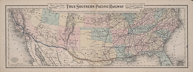
English: Map Showing the Line of the True Southern Pacific Railway and the Short Link necessary for its Completion |
||||||||||||||||||||||||||
| Beschreibung |
English: The Southern Pacific Railroad, chartered in California in 1865 to build a railroad between San Francisco and San Diego, was purchased in 1868 by the group of California railroad investors known as "the Big Four" – Leland Stanford, Collis P. Huntington, Charles Crocker, and Mark Hopkins – who merged it with their Central Pacific in 1870. By 1877 the S. P. stretched eastward into Arizona. By 1878 Huntington also had heavy investments in the Texas-based Galveston, Harrisburg and San Antonio Railway and the Texas and New Orleans Railroad. By 1881 the S. P. had reached El Paso and had control of both these railroads, the Louisiana Western Railroad Extension Company, and Morgan's Louisiana and Texas Railroad and Steamship Company. In 1883 the Southern Pacific and its affiliates completed yet another transcontinental route in 1883, when the construction crews of the G. H. & S. A. and the S. P. met just west of the Pecos River. By 1900 the Southern Pacific and its affiliates owned more miles of track than any other line in Texas.
|
||||||||||||||||||||||||||
| Datum | etwa 1881 | ||||||||||||||||||||||||||
| Quelle | UTA Libraries Cartographic Connections: Karte / Text | ||||||||||||||||||||||||||
| Urheber |
G. W. & C. B. Colton |
||||||||||||||||||||||||||
| Anerkennung |
English: The University of Texas at Arlington Libraries Special Collections |
||||||||||||||||||||||||||
| Kartografische Angaben | |||||||||||||||||||||||||||
| Ortsbezug | Vereinigte Staaten | ||||||||||||||||||||||||||
| Georeferenzierung | If inappropriate please set warp_status = skip to hide. | ||||||||||||||||||||||||||
| Erscheinungsort | New York City | ||||||||||||||||||||||||||
| Archivalische Angaben | |||||||||||||||||||||||||||
| Sammlung |
|
||||||||||||||||||||||||||
| Maße | Höhe: 22,5 cm; Breite: 61,5 cm | ||||||||||||||||||||||||||
| Technik |
farbiges Zerographie farbige Lithografie |
||||||||||||||||||||||||||
| artwork-references |
Orsi, Richard (2005) Sunset Limited: The Southern Pacific Railroad and the Development of the American West, 1850-1930, Berkeley: University of California Press Peterson, Anne The Southern Pacific Railroad: The Road of a Thousand Wonders, Dallas: DeGolyer Library, SMU, S. 2,005 |
||||||||||||||||||||||||||
Lizenz

|
This file was provided to Wikimedia Commons by the University of Texas at Arlington Libraries as part of a cooperation project. The University of Texas at Arlington Libraries is part of the University of Texas at Arlington, a public research university located in Arlington, Texas.
|
Dieses Werk wurde vor dem 1. Januar 1929 veröffentlicht und ist anonym oder pseudonym wegen unbekannter Urheberschaft. Es ist in den Vereinigten Staaten sowie in Ländern und Gebieten mit einer Schutzfrist für anonyme oder pseudonyme Werke von 95 Jahren oder weniger nach der Veröffentlichung gemeinfrei.
|
Dateiversionen
Klicke auf einen Zeitpunkt, um diese Version zu laden.
| Version vom | Vorschaubild | Maße | Benutzer | Kommentar | |
|---|---|---|---|---|---|
| aktuell | 17:34, 13. Apr. 2022 | 9.594 × 3.594 (9,22 MB) | Michael Barera | == {{int:filedesc}} == {{Map |title = {{en|'''''Map Showing the Line of the True Southern Pacific Railway and the Short Link necessary for its Completion'''''}} |description = {{en|The Southern Pacific Railroad, chartered in California in 1865 to build a railroad between San Francisco and San Diego, was purchased in 1868 by the group of California railroad investors known as "the Big Four" – Leland Stanford, Collis P. Huntington, Charles Crocker, and Mark Hopkins – who mer... |
Dateiverwendung
Die folgende Seite verwendet diese Datei:
Globale Dateiverwendung
Die nachfolgenden anderen Wikis verwenden diese Datei:
- Verwendung auf en.wikipedia.org
- Verwendung auf es.wikipedia.org
- Verwendung auf fr.wikipedia.org
- Verwendung auf hu.wikipedia.org
- Verwendung auf it.wikipedia.org
- Verwendung auf pt.wikipedia.org