Datei:Greater Croatia 01.png
Zur Navigation springen
Zur Suche springen
Größe dieser Vorschau: 663 × 600 Pixel. Weitere Auflösungen: 265 × 240 Pixel | 531 × 480 Pixel | 849 × 768 Pixel | 1.151 × 1.041 Pixel
Originaldatei (1.151 × 1.041 Pixel, Dateigröße: 153 KB, MIME-Typ: image/png)
![]()
Diese Datei und die Informationen unter dem roten Trennstrich werden aus dem zentralen Medienarchiv Wikimedia Commons eingebunden.
![]()
Beschreibung
| Beschreibung |
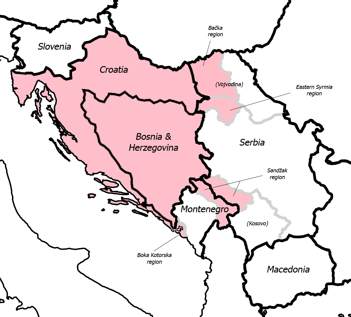
English: Fixed some detail, used overlaid Sandzak, Backa & Syrmium regions so it's much more accurate now. Pink coloring denotes regions claimed by Greater Croatian proponents. Current country borders are black, regional borders (only those that are relevant to the article) are grey.
CommentMap is still wrong:) Croatian-Slovenian border in Istria is 20 kilometars southern that it should be (Umag and Savudrija are in Croatia, hej!) And borders of eastern Srijem are not correct (Zemun and Novi Beograd are part of Srijem, too).
|
| Datum | 24. Mai 2006 (Original-Hochladedatum) |
| Quelle | Übertragen aus en.wikipedia nach Commons. |
| Urheber | Dr.Gonzo in der Wikipedia auf Englisch |
| Andere Versionen |
|


Lizenz
| Dieses Werk wurde von seinem Urheber Dr.Gonzo in der Wikipedia auf Englisch als gemeinfrei veröffentlicht. Dies gilt weltweit. In manchen Staaten könnte dies rechtlich nicht möglich sein. Sofern dies der Fall ist: Dr.Gonzo gewährt jedem das bedingungslose Recht, dieses Werk für jedweden Zweck zu nutzen, es sei denn, Bedingungen sind gesetzlich erforderlich. |
Ursprüngliches Datei-Logbuch
Die ursprüngliche Dateibeschreibungsseite war hier. Alle folgenden Benutzernamen beziehen sich auf en.wikipedia.
- 2007-03-13 10:42 Dr.Gonzo 1151×1041×8 (156832 bytes) Fixed the Istria border (sorry for that, the blank map I used already had that mistake)
- 2006-05-24 22:25 Dr.Gonzo 1151×1041×8 (154088 bytes) Fixed some detail, used overlayed Sandzak, Backa & Syrmium regions so it's much more accurate now.
- 2006-05-24 19:10 Dr.Gonzo 1151×1041×8 (153078 bytes) First version, self made. Some minor geographical detail may be incorrect. Pink coloring denotes regions claimed by Greater Croatian proponents.
Dateiversionen
Klicke auf einen Zeitpunkt, um diese Version zu laden.
| Version vom | Vorschaubild | Maße | Benutzer | Kommentar | |
|---|---|---|---|---|---|
| aktuell | 00:40, 26. Feb. 2008 | | 1.151 × 1.041 (153 KB) | File Upload Bot (Magnus Manske) | {{BotMoveToCommons|en.wikipedia}} {{Information |Description={{en|Fixed some detail, used overlaid Sandzak, Backa & Syrmium regions so it's much more accurate now. Pink coloring denotes regions claimed by Greater Croatian proponents. Current country bord |
Dateiverwendung
Die folgende Seite verwendet diese Datei:
Globale Dateiverwendung
Die nachfolgenden anderen Wikis verwenden diese Datei:
- Verwendung auf ar.wikipedia.org
- Verwendung auf bs.wikipedia.org
- Verwendung auf cs.wikipedia.org
- Verwendung auf el.wikipedia.org
- Verwendung auf en.wikipedia.org
- Verwendung auf id.wikipedia.org
- Verwendung auf ja.wikipedia.org
- Verwendung auf pt.wikipedia.org
- Verwendung auf sh.wikipedia.org
- Verwendung auf sr.wikipedia.org
- Verwendung auf uk.wikipedia.org
- Verwendung auf www.wikidata.org