Datei:Imperial Palace Tokyo Map.svg
Zur Navigation springen
Zur Suche springen

Größe der PNG-Vorschau dieser SVG-Datei: 383 × 500 Pixel. Weitere aus SVG automatisch erzeugte PNG-Grafiken in verschiedenen Auflösungen: 184 × 240 Pixel | 368 × 480 Pixel | 588 × 768 Pixel | 784 × 1.024 Pixel | 1.569 × 2.048 Pixel
Originaldatei (SVG-Datei, Basisgröße: 383 × 500 Pixel, Dateigröße: 384 KB)
![]()
Diese Datei und die Informationen unter dem roten Trennstrich werden aus dem zentralen Medienarchiv Wikimedia Commons eingebunden.
![]()
| Beschreibung |
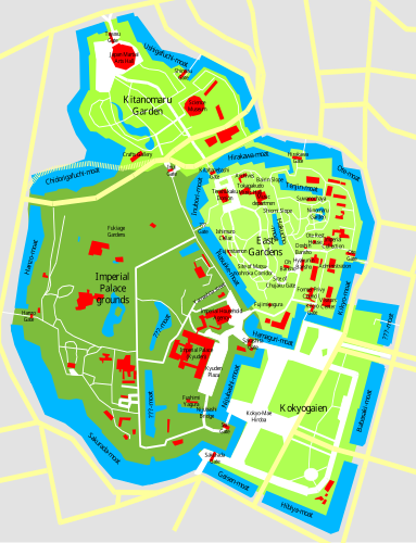
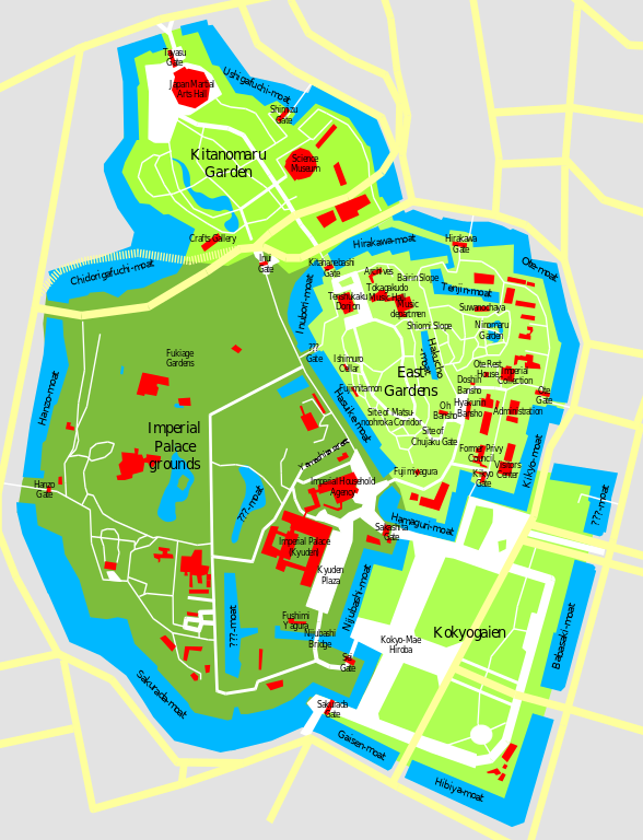
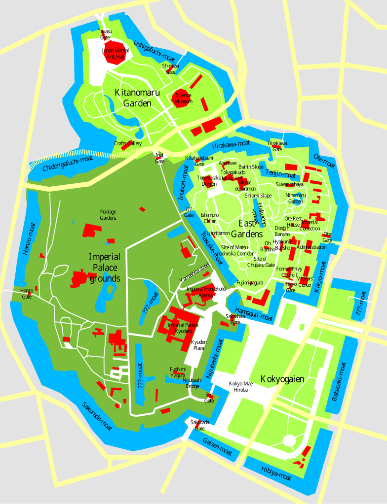
This is the SVG version of Image:Imperial Palace Tokyo Map.sxd, checked with a GoogleMaps Satellite Image and corrected for proportions. Notes by the original authoru: This is a map of the Imperial Palace in Tokyo (Kokyo), drawn by me based on various sources and satelite pics. Disclaimer: Many locations are only approximate, not all streets, buildings, and waterways are shown, I give no guarantee for accuracy, use at your own risk. |
| Datum | (UTC) |
| Quelle | |
| Urheber |
|
Ich, der Urheberrechtsinhaber dieses Werkes, veröffentliche es hiermit unter der folgenden Lizenz:
Diese Datei ist unter der Creative-Commons-Lizenz „Namensnennung – Weitergabe unter gleichen Bedingungen 3.0 nicht portiert“ lizenziert.
- Dieses Werk darf von dir
- verbreitet werden – vervielfältigt, verbreitet und öffentlich zugänglich gemacht werden
- neu zusammengestellt werden – abgewandelt und bearbeitet werden
- Zu den folgenden Bedingungen:
- Namensnennung – Du musst angemessene Urheber- und Rechteangaben machen, einen Link zur Lizenz beifügen und angeben, ob Änderungen vorgenommen wurden. Diese Angaben dürfen in jeder angemessenen Art und Weise gemacht werden, allerdings nicht so, dass der Eindruck entsteht, der Lizenzgeber unterstütze gerade dich oder deine Nutzung besonders.
- Weitergabe unter gleichen Bedingungen – Wenn du das Material wiedermischst, transformierst oder darauf aufbaust, musst du deine Beiträge unter der gleichen oder einer kompatiblen Lizenz wie das Original verbreiten.

|
Es ist erlaubt, die Datei unter den Bedingungen der GNU-Lizenz für freie Dokumentation, Version 1.3 oder einer späteren Version, veröffentlicht von der Free Software Foundation, zu kopieren, zu verbreiten und/oder zu modifizieren; es gibt keine unveränderlichen Abschnitte, keinen vorderen und keinen hinteren Umschlagtext.
Der vollständige Text der Lizenz ist im Kapitel GNU-Lizenz für freie Dokumentation verfügbar. |
Du darfst es unter einer der obigen Lizenzen deiner Wahl verwenden.
Ursprüngliches Datei-Logbuch
This image is a derivative work of the following images:
- File:Imperial_Palace_Tokyo_Map.png licensed with Cc-by-sa-3.0, GFDL-1.3
- 2006-01-02T09:52:23Z Chris 73 834x989 (67236 Bytes)
- 2006-01-01T12:16:22Z Chris 73 828x1026 (65523 Bytes) This is a map of the Imperial Palace in Tokyo (Kokyo), drawn by me based on various sources and satelite pics. See [[.Imperial_Palace_Tokyo_Map.sxd]] for the OpenOffice.Org source file where the entire map can be edited.
Hochgeladen mit derivativeFX
Dateiversionen
Klicke auf einen Zeitpunkt, um diese Version zu laden.
| Version vom | Vorschaubild | Maße | Benutzer | Kommentar | |
|---|---|---|---|---|---|
| aktuell | 02:43, 21. Nov. 2009 | | 383 × 500 (384 KB) | Justass | cropped |
| 02:40, 21. Nov. 2009 |  | 500 × 500 (384 KB) | Justass | ? | |
| 02:20, 21. Nov. 2009 |  | 512 × 668 (361 KB) | ExplicitImplicity | {{Information |Description=This is the SVG version of Image:Imperial Palace Tokyo Map.sxd, checked with a GoogleMaps Satellite Image and corrected for proportions. Notes by the original authoru: This is a map of the Imperial Palace in Tokyo (Kokyo |
Dateiverwendung
Die folgende Seite verwendet diese Datei:
Globale Dateiverwendung
Die nachfolgenden anderen Wikis verwenden diese Datei:
- Verwendung auf ca.wikipedia.org
- Verwendung auf en.wikipedia.org
- Verwendung auf fr.wikipedia.org
- Verwendung auf it.wikipedia.org
- Verwendung auf it.wikivoyage.org
- Verwendung auf ms.wikipedia.org
- Verwendung auf ru.wikipedia.org
- Verwendung auf simple.wikipedia.org
- Verwendung auf sv.wikipedia.org
- Verwendung auf www.wikidata.org