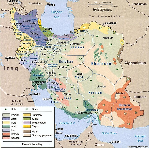
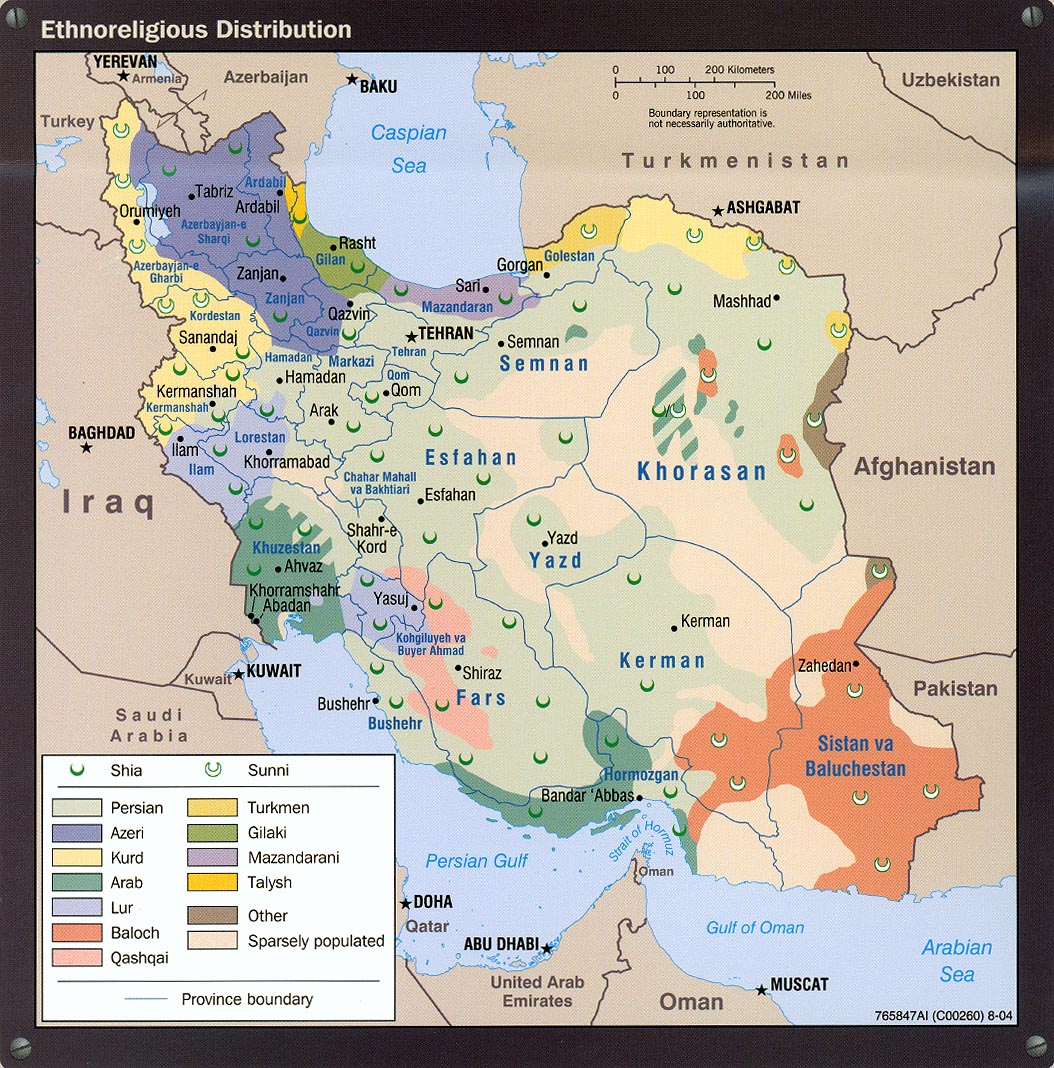
Datei:Iran ethnoreligious distribution 2004.jpg
Zur Navigation springen
Zur Suche springen

Größe dieser Vorschau: 606 × 600 Pixel. Weitere Auflösungen: 242 × 240 Pixel | 485 × 480 Pixel | 980 × 970 Pixel
Originaldatei (980 × 970 Pixel, Dateigröße: 308 KB, MIME-Typ: image/jpeg)
![]()
Diese Datei und die Informationen unter dem roten Trennstrich werden aus dem zentralen Medienarchiv Wikimedia Commons eingebunden.
![]()

Beschreibung
| Beschreibung |
Bahasa Melayu: Iran — peta taburan etnik berdasarkan agama.
فارسی: نقشهٔ پراکنش قومی و مذهبی ایران در ۲۰۰۴ (انگلیسی) |
| Quelle | http://www.lib.utexas.edu/maps/middle_east_and_asia/iran_ethnoreligious_distribution_2004.jpg |
| Urheber | Central Intelligence Agency |
| Genehmigung (Weiternutzung dieser Datei) |
Above the list of maps available for download, the web site has the text: The following maps were produced by the U.S. Central Intelligence Agency, unless otherwise indicated. There is no indication that this map was not produced by the CIA. |
Lizenz
| Dieses Bild ist eine Arbeit eines CIA-Mitarbeiters. Als ein Werk der Regierung der Vereinigten Staaten ist dieses Bild in den USA gemeinfrei.
|

|
Dateiversionen
Klicke auf einen Zeitpunkt, um diese Version zu laden.
| Version vom | Vorschaubild | Maße | Benutzer | Kommentar | |
|---|---|---|---|---|---|
| aktuell | 19:38, 28. Jul. 2021 | | 980 × 970 (308 KB) | GPinkerton | Reverted to version as of 20:33, 13 December 2005 (UTC) Back to the original image, yet again. See https://lccn.loc.gov/2005634048 for the original 2004 CIA "Iran country profile" info-graphic of which this map is a part. |
| 20:24, 23. Feb. 2015 |  | 980 × 970 (419 KB) | Lantad | original map is not correct | |
| 04:05, 23. Dez. 2014 |  | 980 × 970 (308 KB) | Abrahamic Faiths | I assume that User:HistoryofIran reverted to this version by mistake, the lurs are not this widely spread, keep consistent with this map | |
| 16:02, 8. Okt. 2014 |  | 980 × 970 (419 KB) | HistoryofIran | Removed vandalism by puppet account. | |
| 16:07, 28. Sep. 2014 |  | 980 × 970 (419 KB) | Apiculate | You are going to say half of lorestan province are not lur ? | |
| 16:06, 28. Sep. 2014 |  | 980 × 970 (419 KB) | Apiculate | You are going to say half of lorestan province are not lur ? | |
| 20:57, 14. Sep. 2014 |  | 980 × 970 (308 KB) | HistoryofIran | Removed disprutive edit; that doesn't make any sense. | |
| 00:25, 12. Sep. 2014 |  | 980 × 970 (419 KB) | Apiculate | in ethnologue, Bakhtiari considered a dialect of luri language ,Source: http://www.ethnologue.com/language/bqi/view/***EDITION*** | |
| 18:12, 15. Aug. 2014 |  | 980 × 970 (308 KB) | HistoryofIran | Removed disprutive edit. | |
| 12:56, 7. Aug. 2014 |  | 980 × 970 (419 KB) | Apiculate | Reverted to version as of 06:16, 6 June 2014 |
Dateiverwendung
Die folgende Seite verwendet diese Datei:
Globale Dateiverwendung
Die nachfolgenden anderen Wikis verwenden diese Datei:
- Verwendung auf af.wikipedia.org
- Verwendung auf av.wikipedia.org
- Verwendung auf ba.wikipedia.org
- Verwendung auf cs.wikipedia.org
- Verwendung auf en.wikipedia.org
- Verwendung auf en.wikinews.org
- Verwendung auf fa.wikipedia.org
- Verwendung auf he.wikipedia.org
- Verwendung auf hr.wikipedia.org
- Verwendung auf hu.wikipedia.org
- Verwendung auf it.wikipedia.org
- Verwendung auf ka.wikipedia.org
- Verwendung auf nl.wikipedia.org
- Verwendung auf nn.wikipedia.org
- Verwendung auf no.wikipedia.org
- Verwendung auf pt.wikipedia.org
- Verwendung auf ru.wikipedia.org
- Verwendung auf sh.wikipedia.org
- Verwendung auf simple.wikipedia.org
- Verwendung auf sr.wikipedia.org
- Verwendung auf tg.wikipedia.org
- Verwendung auf tr.wikipedia.org
- Verwendung auf tt.wikipedia.org
- Verwendung auf zh.wikipedia.org