Datei:Karte Segelfluggelände Deutschland.svg
Zur Navigation springen
Zur Suche springen

Größe der PNG-Vorschau dieser SVG-Datei: 443 × 599 Pixel. Weitere aus SVG automatisch erzeugte PNG-Grafiken in verschiedenen Auflösungen: 177 × 240 Pixel | 355 × 480 Pixel | 568 × 768 Pixel | 758 × 1.024 Pixel | 1.515 × 2.048 Pixel | 512 × 692 Pixel
Originaldatei (SVG-Datei, Basisgröße: 512 × 692 Pixel, Dateigröße: 237 KB)
![]()
Diese Datei und die Informationen unter dem roten Trennstrich werden aus dem zentralen Medienarchiv Wikimedia Commons eingebunden.
![]()
Beschreibung
| Beschreibung |
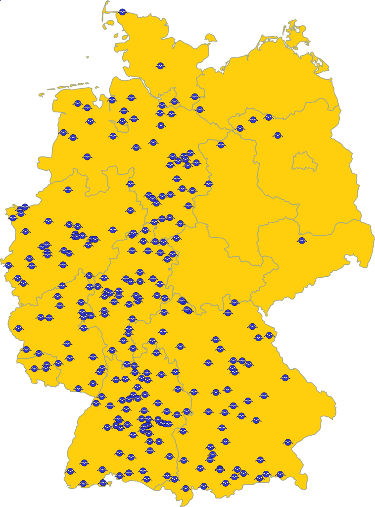
English: Map of the “Segelfluggelände” (special kind of airfield, where more or less only sailplanes are allowed) in Germany
Deutsch: Karte der de:Segelfluggelände in Deutschland |
| Datum | |
| Quelle |
|
| Urheber | El Grafo |
| SVG‑Erstellung |
Lizenz
Ich, der Urheber dieses Werkes, veröffentliche es unter der folgenden Lizenz:
| Diese Datei wird unter der Creative-Commons-Lizenz „CC0 1.0 Verzicht auf das Copyright“ zur Verfügung gestellt. | |
| Die Person, die das Werk mit diesem Dokument verbunden hat, übergibt dieses weltweit der Gemeinfreiheit, indem sie alle Urheberrechte und damit verbundenen weiteren Rechte – im Rahmen der jeweils geltenden gesetzlichen Bestimmungen – aufgibt. Das Werk kann – selbst für kommerzielle Zwecke – kopiert, modifiziert und weiterverteilt werden, ohne hierfür um Erlaubnis bitten zu müssen.
|
Dateiversionen
Klicke auf einen Zeitpunkt, um diese Version zu laden.
| Version vom | Vorschaubild | Maße | Benutzer | Kommentar | |
|---|---|---|---|---|---|
| aktuell | 19:08, 9. Dez. 2010 | | 512 × 692 (237 KB) | Fleshgrinder | Slight code optimization, title element, added support for embedding the graphic directly in HTML via the object element (width=100% height=100% viewBox"x x x x"), ... |
| 20:23, 8. Dez. 2010 |  | 399 × 539 (244 KB) | Perhelion | use clone object | |
| 22:00, 29. Nov. 2010 |  | 786 × 1.063 (340 KB) | El Grafo | Reverted to version as of 14:25, 29 November 2010 | |
| 22:00, 29. Nov. 2010 |  | 524 × 744 (658 KB) | El Grafo | svg-output from qgis (for discussion) | |
| 16:25, 29. Nov. 2010 |  | 786 × 1.063 (340 KB) | El Grafo | remove remnants of embedded raster graphics | |
| 16:21, 29. Nov. 2010 |  | 786 × 1.063 (445 KB) | El Grafo | previous version was saved in Inkscape as "Inkscape-SVG" | |
| 16:15, 29. Nov. 2010 |  | 786 × 1.063 (584 KB) | El Grafo | Reverted to version as of 17:41, 28 November 2010 | |
| 16:13, 29. Nov. 2010 |  | 399 × 539 (995 KB) | El Grafo | Version with embedded raster graphics (for discussion) | |
| 19:41, 28. Nov. 2010 |  | 786 × 1.063 (584 KB) | El Grafo | bigger | |
| 19:30, 28. Nov. 2010 |  | 431 × 582 (445 KB) | El Grafo | {{Information |Description={{en|1=Map of the “Segelfluggelände” (special kind of airfield, where more or less only sailplanes are allowed) in Germany }} {{de|1=Karte der de:Segelfluggelände in Deutschland}} |Source=*{{own}} *mapdata from [http: |
Dateiverwendung
Die folgenden 3 Seiten verwenden diese Datei: