Datei:La Palma in Canary Islands - satellite image ISS017-E-06820 lrg.jpg
Originaldatei (1.080 × 810 Pixel, Dateigröße: 469 KB, MIME-Typ: image/jpeg)
![]()
Diese Datei und die Informationen unter dem roten Trennstrich werden aus dem zentralen Medienarchiv Wikimedia Commons eingebunden.
![]()
Beschreibung
| Beschreibung |
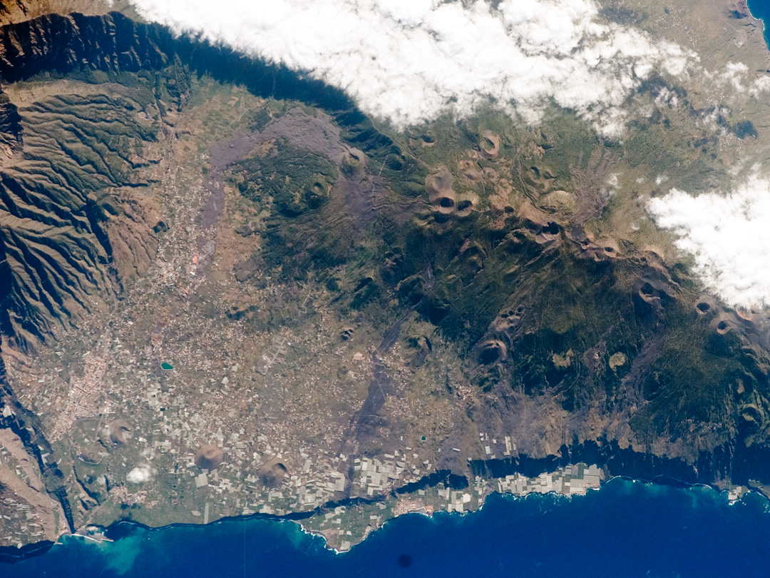
English: The Canary Islands, a group of volcanic islands, lie just off the west coast of Morocco in the Atlantic Ocean; at the northwest end of the chain is Isla de la Palma (pictured here). The island started forming as a submarine volcano approximately 3-4 million years ago. Subaerial (above the water surface) volcanic activity and island formation began around 2 million years ago. Most geologists believe the Canary Islands formed over the remnants of an old “hotspot” in the mantle, or mantle plume. The residual hotspot melting produced the magma that resulted in the Canary Island volcanoes. While there is little evidence to support the current existence of a mantle plume, volcanic activity is still taking place—the most recent lava flows on Isla de Palma were erupted in 1971. In addition to volcanic hazards, the Canary Islands are also subject to occasional dust storms originating in the Sahara Desert.
This astronaut photograph highlights volcanic landforms on the southern portion of Isla de la Palma. The elongated, 1,949-meter (6,394-foot) high Cumbre Vieja volcanic center is characterized by numerous cinder cones, craters, and gray lava flows that punctuate the green vegetated hills. To the north, the cities of El Paso and Los Llanos de Aridanes nestle against collapsed fragments of the Caldera Taburiente (image left), formed by massive slope failure of an older volcanic center to the north. Tourism is a major component of the local economy, but the high mountains and clear air of Isla de la Palma are also attractive to astronomers; several large observatories (not shown) are located along the northern edge of the Caldera Taburiente. Astronaut photograph ISS017-E-6820 was acquired May 13, 2008, with a Kodak 760C digital camera using a 400 mm lens, and is provided by the ISS Crew Earth Observations experiment. The image was taken by the Expedition 17 crew, and is provided by the Image Science & Analysis Laboratory, Johnson Space Center. The image in this article has been cropped and enhanced to improve contrast. Lens artifacts have been removed. The International Space Station Program supports the laboratory to help astronauts take pictures of Earth that will be of the greatest value to scientists and the public, and to make those images freely available on the Internet. Additional images taken by astronauts and cosmonauts can be viewed at the NASA/JSC Gateway to Astronaut Photography of Earth. Caption by William L. Stefanov, NASA-JSC. |
| Datum | |
| Quelle | https://www.earthobservatory.nasa.gov/images/8827/isla-de-la-palma-canary-islands |
| Urheber | International Space Station - Expedition 17 crew |
Lizenz
| Diese Datei ist gemeinfrei (public domain), da sie von der NASA erstellt worden ist. Die NASA-Urheberrechtsrichtlinie besagt, dass „NASA-Material nicht durch Urheberrecht geschützt ist, wenn es nicht anders angegeben ist“. (NASA-Urheberrechtsrichtlinie-Seite oder JPL Image Use Policy). | ||
 |
Warnung:
|
| Bildnotizen | Diese Datei ist annotiert: Betrachte diese auf Commons. |
Dateiversionen
Klicke auf einen Zeitpunkt, um diese Version zu laden.
| Version vom | Vorschaubild | Maße | Benutzer | Kommentar | |
|---|---|---|---|---|---|
| aktuell | 23:00, 6. Jan. 2022 | | 1.080 × 810 (469 KB) | GeoWriter | Reverted to version as of 19:07, 30 March 2019 (UTC) - restore original version of image. Any German-language derivative image should be created as a new image with a different file name; the original image should not be lost |
| 13:23, 27. Dez. 2021 |  | 1.080 × 810 (461 KB) | Erledigt | plus Nord-Pfeil | |
| 21:07, 30. Mär. 2019 |  | 1.080 × 810 (469 KB) | GeoWriter | User created page with UploadWizard |
Dateiverwendung
Die folgenden 2 Seiten verwenden diese Datei:
Globale Dateiverwendung
Die nachfolgenden anderen Wikis verwenden diese Datei:
- Verwendung auf cs.wikipedia.org
- Verwendung auf en.wikipedia.org
- Verwendung auf frr.wikipedia.org
- Verwendung auf sl.wikipedia.org