Datei:Mackenzie river enters Beaufort sea.jpg

Originaldatei (9.000 × 7.500 Pixel, Dateigröße: 64 MB, MIME-Typ: image/jpeg)
![]()
Diese Datei und die Informationen unter dem roten Trennstrich werden aus dem zentralen Medienarchiv Wikimedia Commons eingebunden.
![]()
Beschreibung
| Beschreibung |
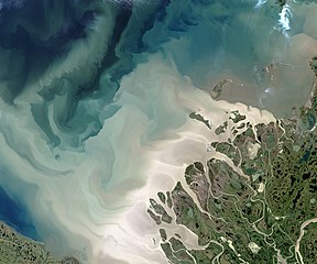
English: The Mackenzie River is the leading source of freshwater flowing into the Arctic Ocean. It's also a leading source of sediment flowing into that basin.
The Operational Land Imager (OLI) on the Landsat 8 satellite acquired this image of the Mackenzie Delta on July 19, 2017. At the time, the Beaufort Sea was colored with milky, tan brush strokes of sediment in various levels of dispersal after pouring out of the river. The Mackenzie is the largest and longest northward-flowing river in North America, and the second largest on the continent (after the Mississippi). The watershed drains a huge, but mostly unsettled portion of Canada; population density along the 4,200 kilometer (2,600 mile) river is just 1 person per square kilometer. About 7 percent of the fresh water that flows into the Arctic Ocean each year comes out the Mackenzie and its delta, and much of that comes in large pulses in June and July after the freshet—when inland ice and snow melts and floods the river. The spring flood carries with it tremendous amounts of dissolved organic material and sediment. More info & refs at source. |
| Datum | acquired July 19, 2017 |
| Quelle | https://earthobservatory.nasa.gov/IOTD/view.php?id=90703&src=eoa-iotd |
| Urheber | NASA Earth Observatory images by Jesse Allen, using Landsat data from the U.S. Geological Survey |
Lizenz
| Diese Datei ist gemeinfrei (public domain), da sie von der NASA erstellt worden ist. Die NASA-Urheberrechtsrichtlinie besagt, dass „NASA-Material nicht durch Urheberrecht geschützt ist, wenn es nicht anders angegeben ist“. (NASA-Urheberrechtsrichtlinie-Seite oder JPL Image Use Policy). | ||
 |
Warnung:
|
Dateiversionen
Klicke auf einen Zeitpunkt, um diese Version zu laden.
| Version vom | Vorschaubild | Maße | Benutzer | Kommentar | |
|---|---|---|---|---|---|
| aktuell | 09:28, 7. Jan. 2021 | | 9.000 × 7.500 (64 MB) | StellarHalo | higher resolution |
| 07:25, 9. Aug. 2017 |  | 720 × 600 (276 KB) | Tillman | {{Information |Description ={{en|1=The Mackenzie River is the leading source of freshwater flowing into the Arctic Ocean. It's also a leading source of sediment flowing into that basin. The Operational Land Imager (OLI) on the Landsat 8 satellite a... |
Dateiverwendung
Die folgende Seite verwendet diese Datei:
Globale Dateiverwendung
Die nachfolgenden anderen Wikis verwenden diese Datei:
- Verwendung auf en.wikipedia.org
- Verwendung auf sl.wikipedia.org
- Verwendung auf uz.wikipedia.org