Datei:Map Victoria Aboriginal tribes (colourmap).jpg
Zur Navigation springen
Zur Suche springen
Größe dieser Vorschau: 800 × 556 Pixel. Weitere Auflösungen: 320 × 222 Pixel | 640 × 445 Pixel | 1.024 × 711 Pixel | 1.280 × 889 Pixel | 2.560 × 1.778 Pixel | 3.523 × 2.447 Pixel
Originaldatei (3.523 × 2.447 Pixel, Dateigröße: 440 KB, MIME-Typ: image/jpeg)
![]()
Diese Datei und die Informationen unter dem roten Trennstrich werden aus dem zentralen Medienarchiv Wikimedia Commons eingebunden.
![]()
.jpg?uselang=de)

|
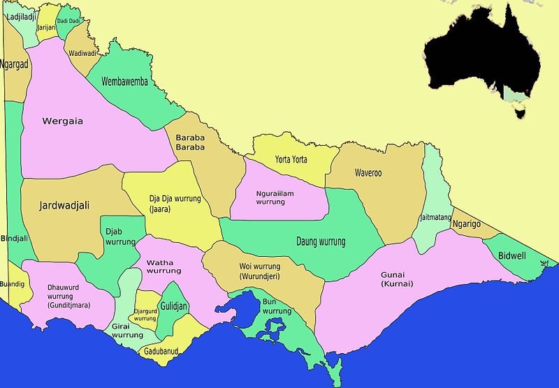
File:Map Victoria Aboriginal tribes.svg ist eine vektorisierte Version dieses Bildes. Diese sollte an Stelle des Rasterbildes verwendet werden, sofern sie nicht schlechter ist.
File:Map Victoria Aboriginal tribes (colourmap).jpg → File:Map Victoria Aboriginal tribes.svg
Für weitere Informationen siehe Help:SVG. |
 |
Beschreibung
| Beschreibung |
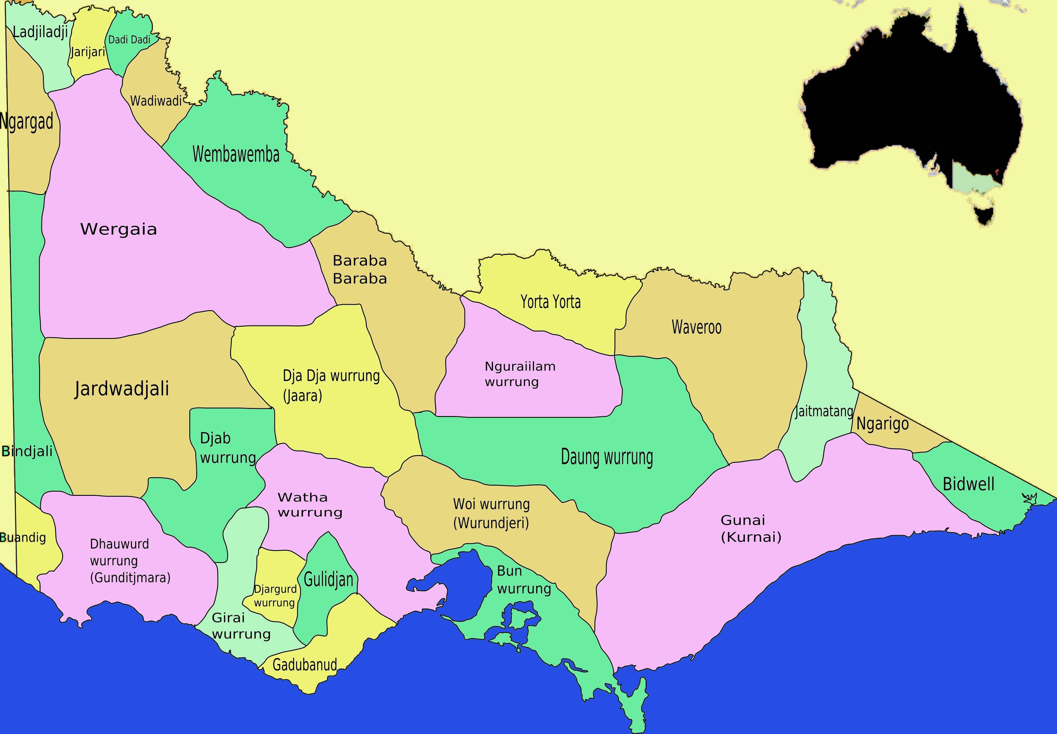
English: This is a map I created of aboriginal tribal territories and languages in Victoria, Australia coloured to easily distinguish different tribal areas derived from Image:Map Victoria Aboriginal tribes.svg which was also drawn by myself. The drawing is based on information and a map drawing in Ian D. Clark, Scars on the Landscape. A Register of Massacre sites in Western Victoria 1803-1859, Aboriginal Studies Press, 1995 ISBN 0855752815. To a lesser degree information was correlated with the Aboriginal Australian Map published by AIATSIS, especially for border areas and east Victoria.[1]. - Takver |
| Datum | |
| Quelle | Eigenes Werk |
| Urheber | Tirin aka Takver |
| Andere Versionen |
|
Lizenz
Ich, der Urheberrechtsinhaber dieses Werkes, veröffentliche es hiermit unter der folgenden Lizenz:
Diese Datei ist unter der Creative-Commons-Lizenz „Namensnennung – Weitergabe unter gleichen Bedingungen 3.0 nicht portiert“ lizenziert.
- Dieses Werk darf von dir
- verbreitet werden – vervielfältigt, verbreitet und öffentlich zugänglich gemacht werden
- neu zusammengestellt werden – abgewandelt und bearbeitet werden
- Zu den folgenden Bedingungen:
- Namensnennung – Du musst angemessene Urheber- und Rechteangaben machen, einen Link zur Lizenz beifügen und angeben, ob Änderungen vorgenommen wurden. Diese Angaben dürfen in jeder angemessenen Art und Weise gemacht werden, allerdings nicht so, dass der Eindruck entsteht, der Lizenzgeber unterstütze gerade dich oder deine Nutzung besonders.
- Weitergabe unter gleichen Bedingungen – Wenn du das Material wiedermischst, transformierst oder darauf aufbaust, musst du deine Beiträge unter der gleichen oder einer kompatiblen Lizenz wie das Original verbreiten.

|
Es ist erlaubt, die Datei unter den Bedingungen der GNU-Lizenz für freie Dokumentation, Version 1.2 oder einer späteren Version, veröffentlicht von der Free Software Foundation, zu kopieren, zu verbreiten und/oder zu modifizieren; es gibt keine unveränderlichen Abschnitte, keinen vorderen und keinen hinteren Umschlagtext.
Der vollständige Text der Lizenz ist im Kapitel GNU-Lizenz für freie Dokumentation verfügbar. |
Du darfst es unter einer der obigen Lizenzen deiner Wahl verwenden.
Dateiversionen
Klicke auf einen Zeitpunkt, um diese Version zu laden.
| Version vom | Vorschaubild | Maße | Benutzer | Kommentar | |
|---|---|---|---|---|---|
| aktuell | 14:38, 21. Dez. 2008 | | 3.523 × 2.447 (440 KB) | Tirin | {{Information |Description={{en|1=This is a map I created of aboriginal tribal territories and languages in Victoria, Australia coloured to easily distinguish different tribal areas derived from Image:ap Victoria Aboriginal tribes.svg which was also |
Dateiverwendung
Die folgenden 4 Seiten verwenden diese Datei:
Globale Dateiverwendung
Die nachfolgenden anderen Wikis verwenden diese Datei:
- Verwendung auf en.wikipedia.org
- History of Victoria
- Aboriginal Australians
- Bidhawal
- Yorta Yorta
- Wemba-Wemba
- Jardwadjali
- Djab Wurrung people
- Gadubanud
- Aboriginal Victorians
- Wergaia language
- Jarijari
- Registered Aboriginal Party
- Dadi Dadi
- Warkawarka
- Barengi Gadjin Land Council Aboriginal Corporation
- User:Jack Frost/Aboriginal Australians
- Verwendung auf en.wikiversity.org
- Verwendung auf fr.wikipedia.org
- Verwendung auf gl.wikipedia.org
- Verwendung auf ms.wikipedia.org
- Verwendung auf ru.wikipedia.org
- Verwendung auf simple.wikipedia.org
- Verwendung auf tr.wikipedia.org
.jpg)