Datei:Map of Transcontiental nations.png
Zur Navigation springen
Zur Suche springen

Größe dieser Vorschau: 800 × 351 Pixel. Weitere Auflösungen: 320 × 140 Pixel | 640 × 281 Pixel | 1.425 × 625 Pixel
Originaldatei (1.425 × 625 Pixel, Dateigröße: 40 KB, MIME-Typ: image/png)
![]()
Diese Datei und die Informationen unter dem roten Trennstrich werden aus dem zentralen Medienarchiv Wikimedia Commons eingebunden.
![]()
Misspelt title of map: Transcontiental>Transcontinental
Only two shades of blue distinguishable.
Beschreibung
| Beschreibung |
Afrikaans: Kaart van Transkontinentale nasies.
state met 'n aangrensende grens
state met 'n nie-aangrensende grens
state met 'n gebied wat transkontinentale Dansk: Kort over transkontinentale nationer.
stater med en sammenhængende grænse.
stater med en ikke-sammenhængende grænse.
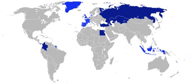
stater med et område, der er transkontinentale. English: Map of transcontinental nations.
states with a contiguous boundary.
states with a non-contiguous boundary.
states with a territory that's transcontinental. Español: Mapa de las naciones transcontinental.
estados con un límite contigua.
estados con un límite no contigua.
Estados con un área de Transcontinental. Français : Carte des pays transcontinentaux.
pays ayant une continuité territoriale de ses frontières.
pays sans continuité territoriale de ses frontières.
pays ayant un territoire transcontinental. Nederlands: Kaart van Transcontinentale naties.
staten met een aangrenzende grens.
staten met een niet-aangrenzende grens.
staten met een gebied dat transcontinentaal is. Türkçe: Kıtalararası Ülkeler.
Bitişik sınır ülkeleri.
Sınırı bitişik olmayan ülkeler.
Denizaşırı toprağı bulunan ülkeler. Русский: Карта Трансконтинентальных стран.
Государства с примыкающей границей.
Государства с несмежной границей.
Государства с Трансконтинентальной площадью. العربية : خريطة الدول عابرة للقارات.
الدول التي لها حدود متماسك.
الدول التي لها حدود غير متجاورة.
الدول التي لديها أراضي هذا هو عابر للقارات. |
| Datum | |
| Quelle | Eigenes Werk |
| Urheber | $200inaire |
Lizenz
Ich, der Urheber dieses Werkes, veröffentliche es unter der folgenden Lizenz:
Diese Datei ist unter der Creative-Commons-Lizenz „Namensnennung – Weitergabe unter gleichen Bedingungen 3.0 nicht portiert“ lizenziert.
- Dieses Werk darf von dir
- verbreitet werden – vervielfältigt, verbreitet und öffentlich zugänglich gemacht werden
- neu zusammengestellt werden – abgewandelt und bearbeitet werden
- Zu den folgenden Bedingungen:
- Namensnennung – Du musst angemessene Urheber- und Rechteangaben machen, einen Link zur Lizenz beifügen und angeben, ob Änderungen vorgenommen wurden. Diese Angaben dürfen in jeder angemessenen Art und Weise gemacht werden, allerdings nicht so, dass der Eindruck entsteht, der Lizenzgeber unterstütze gerade dich oder deine Nutzung besonders.
- Weitergabe unter gleichen Bedingungen – Wenn du das Material wiedermischst, transformierst oder darauf aufbaust, musst du deine Beiträge unter der gleichen oder einer kompatiblen Lizenz wie das Original verbreiten.
Dateiversionen
Klicke auf einen Zeitpunkt, um diese Version zu laden.
| Version vom | Vorschaubild | Maße | Benutzer | Kommentar | |
|---|---|---|---|---|---|
| aktuell | 21:41, 4. Aug. 2014 | | 1.425 × 625 (40 KB) | KronosLine | Added South Sudan, removed Kosovo (either include all breakaway regions or none) |
| 12:32, 5. Apr. 2014 |  | 1.425 × 625 (33 KB) | SeeSchloss | Added French overseas territories (French Guyana, Southern territories, St Pierre & Miquelon, Guadeloupe, Martinique, Réunion, Mayotte, New Caledonia, Wallis & Futuna - I couldn't spot French Polynesia islands on the map) as well as Corsica. Added Spa... | |
| 06:09, 25. Feb. 2014 |  | 1.425 × 625 (40 KB) | Scoelho86 | +POR | |
| 06:33, 31. Jan. 2014 |  | 1.425 × 625 (40 KB) | Scoelho86 | +COL | |
| 09:48, 13. Jun. 2012 |  | 1.425 × 625 (57 KB) | $200inaire | Fix some errors and flaws in the map | |
| 01:16, 11. Jun. 2012 |  | 1.425 × 625 (56 KB) | $200inaire |
Dateiverwendung
Keine Seiten verwenden diese Datei.
Globale Dateiverwendung
Die nachfolgenden anderen Wikis verwenden diese Datei:
- Verwendung auf arz.wikipedia.org
- Verwendung auf da.wikipedia.org
- Verwendung auf la.wikipedia.org
- Verwendung auf ml.wikipedia.org