Datei:Os Alpes.jpg

Originaldatei (4.676 × 4.091 Pixel, Dateigröße: 5,42 MB, MIME-Typ: image/jpeg)
![]()
Diese Datei und die Informationen unter dem roten Trennstrich werden aus dem zentralen Medienarchiv Wikimedia Commons eingebunden.
![]()
Beschreibung
| Beschreibung |
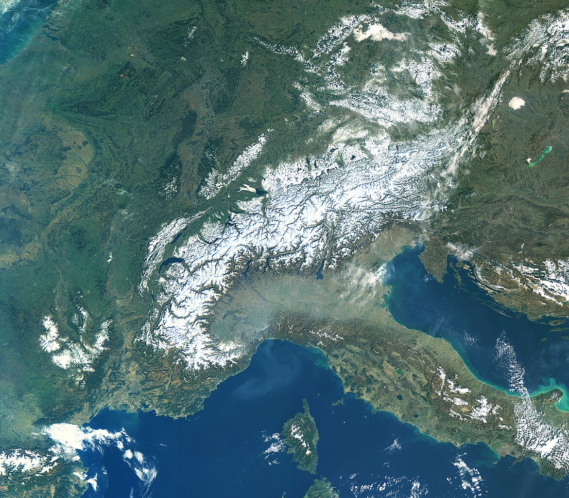
English: The Copernicus Sentinel-3A satellite takes us over the high, snow-studded Alps under clear skies.
The Alps extend 1200 km through eight different countries: France, Monaco, Italy, Switzerland, Liechtenstein, Germany, Austria and Slovenia. This mountain range, which is inhabited by some 20 million people, covers an area of approximately 200 000 sq km. Captured on 16 February 2019, this true-colour image shows little clouds, particularly over the Alps and the surrounding flatter lands in southern France. There is an interesting contrast between this and the haze hanging over the Po valley in Italy, directly south of the Alps. The haze is most likely to be a mix of both fog and smog, trapped at the base of the Alps owing to both its topography and atmospheric conditions. Patches of snow are also visible on the island of Corsica, to the left of mainland Italy, Croatia, to the right, and at the bottom of the Apennines in central Italy. Most of Italy’s rivers find their source in the Apennines, including the Tiber and the Arno. The Adriatic Sea to the east of Italy is visible in turquoise, particularly the coastal area surrounding the Gargano National Park, jutting out. This light-green colour of the sea along the coast is likely to be caused by sediment carried into the sea by river discharge. Directly to the right of the Alps, the image shows a pale-green Lake Neusiedl straddling the Austrian-Hungarian border. Neusiedl, meaning ‘swamp’ in Hungarian, is the largest endorheic lake in central Europe, meaning water flows into but not out of the lake, hence its size and level frequently fluctuates. It is a popular area for windsurfing, sailing and spotting the woolly Mangalica pig. To the right, the freshwater Lake Balaton is visible, and is the largest lake in central Europe. It stretches for over 75 km in the southern foothills of Hungary. Its striking emerald-green colour is probably down to the presence of algae that grow in the shallow waters. Sentinel-3 is a two-satellite mission to supply the coverage and data delivery needed for Europe’s Copernicus environmental monitoring programme. The mission provides critical information for a range of applications from marine observations to large-area vegetation monitoring. The satellite’s instrument package includes an optical sensor to monitor changes in the colour of Earth’s surfaces. This image is also featured on theEarth from Space video programme.Galego: Foto tomada por Copernicus Sentinel 3A, CC BY-SA 3.0 IGO, http://www.esa.int/spaceinimages/Images/2019/03/The_Alps |
| Datum | |
| Quelle | http://www.esa.int/spaceinimages/Images/2019/03/The_Alps |
| Urheber | Copernicus Sentinel / European Space Agency |
Lizenz
- Dieses Werk darf von dir
- verbreitet werden – vervielfältigt, verbreitet und öffentlich zugänglich gemacht werden
- neu zusammengestellt werden – abgewandelt und bearbeitet werden
- Zu den folgenden Bedingungen:
- Namensnennung – Du musst angemessene Urheber- und Rechteangaben machen, einen Link zur Lizenz beifügen und angeben, ob Änderungen vorgenommen wurden. Diese Angaben dürfen in jeder angemessenen Art und Weise gemacht werden, allerdings nicht so, dass der Eindruck entsteht, der Lizenzgeber unterstütze gerade dich oder deine Nutzung besonders.
- Weitergabe unter gleichen Bedingungen – Wenn du das Material wiedermischst, transformierst oder darauf aufbaust, musst du deine Beiträge unter der gleichen oder einer kompatiblen Lizenz wie das Original verbreiten.

|
This image contains data from a satellite in the Copernicus Programme, such as Sentinel-1, Sentinel-2 or Sentinel-3. Attribution is required when using this image.
Namensnennung: Contains modified Copernicus Sentinel data {{{year}}}
The use of Copernicus Sentinel Data is regulated under EU law (Commission Delegated Regulation (EU) No 1159/2013 and Regulation (EU) No 377/2014). Relevant excerpts:
Free access shall be given to GMES dedicated data [...] made available through GMES dissemination platforms [...].
Access to GMES dedicated data [...] shall be given for the purpose of the following use in so far as it is lawful:
GMES dedicated data [...] may be used worldwide without limitations in time.
GMES dedicated data and GMES service information are provided to users without any express or implied warranty, including as regards quality and suitability for any purpose. |
Dateiversionen
Klicke auf einen Zeitpunkt, um diese Version zu laden.
| Version vom | Vorschaubild | Maße | Benutzer | Kommentar | |
|---|---|---|---|---|---|
| aktuell | 21:19, 1. Mär. 2019 | | 4.676 × 4.091 (5,42 MB) | Agremon | User created page with UploadWizard |
Dateiverwendung
Die folgende Seite verwendet diese Datei:
Globale Dateiverwendung
Die nachfolgenden anderen Wikis verwenden diese Datei: