Datei:Peenemunde-165515.jpg
Zur Navigation springen
Zur Suche springen

Größe dieser Vorschau: 800 × 521 Pixel. Weitere Auflösungen: 320 × 209 Pixel | 640 × 417 Pixel | 804 × 524 Pixel
Originaldatei (804 × 524 Pixel, Dateigröße: 301 KB, MIME-Typ: image/jpeg)
![]()
Diese Datei und die Informationen unter dem roten Trennstrich werden aus dem zentralen Medienarchiv Wikimedia Commons eingebunden.
![]()
Beschreibung
| Beschreibung |
English captions of this photograph in published works (Not all sources label each object with the same letter)
|
|||
| Datum | ||||
| Quelle |
|
|||
| Urheber |
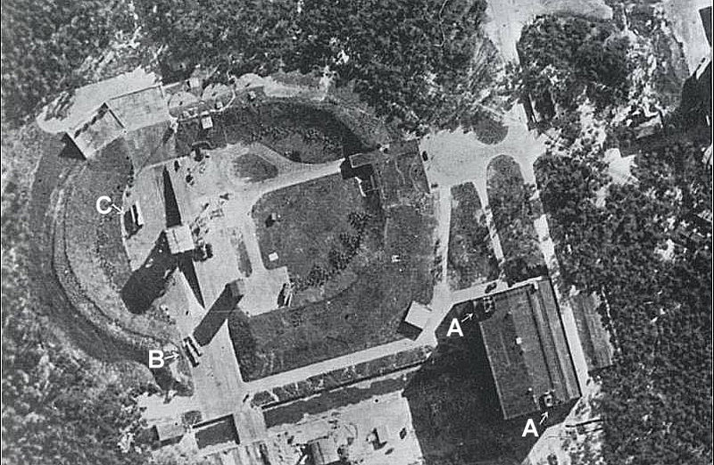
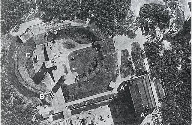
No. 540 Squadron RAF Flight Sergeant E. P. H. Peek in a de Havilland Mosquito PR4[7] returned to Leuchars airfield on June 23, 1943 with Peenemünde photos showing a pair of low-loader vehicles[8] holding a pair of rockets.[2][7] ChronologyThe first RAF photo on April 22, 1943 of a 1 1/2 mm "object" -- A-4 model 21 within Test Stand VII -- was not initially identified as a rocket.[2] After reviewing Peek's June 23 photo, Flight Lieutenant Andre' J. A. Kenny changed the designation of the 1 1/2 -mm-long-specks from 'objects' to 'torpedoes'.[2] Then more than a year after the initial rocket photos (even after Operation Hydra had bombed Peenemünde on August 17/18, 1943 based on other intelligence), a May 5, 1944 photo of Blizna by the Photographic Reconnaissance Unit (PRU) at a new base at San Severo Italy showed a rocket on a narrow-gauge railway line,[2] but the Crossbow committee put the photographs aside.[6] Finally, after the report of the Bug river wreckage, Reginald Victor Jones methodically examined the photographs of Blizna through the night of June 2/3, 1944 and found a faint white line image of the rocket on a loop of the narrow-gauge railway.[6] Kenny subsequently called back earlier Peenemünde photographs and identified several finned 'objects': on railway trucks, outside tall upright buildings, and on the traverser carriage serving the ellipse; as well as evidence of a heavy and violent explosion with blast damages to buildings at the 'launching pad'.[2] |
|||
| Genehmigung (Weiternutzung dieser Datei) |
|
|||
| Andere Versionen | Historisch-technisches Informationszentrum Peenemünde, Life magazine on 12/25/44 pg 48 |

References and footnotes
- ↑ McGovern, J (1964) Crossbow and Overcast, Category:New York: W. Morrow, S. p120c NOTE: The image in Crossbow and Overcast has a scale labeled with 0' and 200'
- ↑ a b c d e f Irving, David (1964) The Mare's Nest, London: William Kimber and Co, S. p50,64a,65,67,69,265 NOTE: The image in The Mare's Nest depicts a wider area including the shoreline and part of the Luftwaffe area.
- ↑ Dornberger, Walter (1952 -- US translation V-2 Viking Press:New York, 1954) V2--Der Schuss ins Weltall, Esslingan: Bechtle Verlag, S. p xvi
- ↑ Russell, Francis; Editors of Time-Life Books (1981) The Secret War, World War II, Alexandria VA: Time-Life Books Inc., S. p162 ISBN: 0-8094-2546-7 (retail ed.). NOTE: The image in The Secret War has a scale labeled with 0' and _00'
- ↑ Baumann, Paul R.. Geo/SAT 2. HISTORY OF REMOTE SENSING, AERIAL PHOTOGRAPHY. College at Oneonta SUNY. Retrieved on January 24, 2008.
- ↑ a b c Garliński, Józef (1978) Hitler's Last Weapons: The Underground War against the V1 and V2, Category:New York: Times Books, S. p100e,146
- ↑ a b Collier, Basil (1976) [1964] The Battle of the V-Weapons, 1944-1945, Yorkshire: The Emfield Press, S. p32,59 ISBN: 0 7057 0070 4.
- ↑ Cooksley, Peter G (1979) Flying Bomb, Category:New York: Charles Scribner’s Sons, S. p53
Dateiversionen
Klicke auf einen Zeitpunkt, um diese Version zu laden.
| Version vom | Vorschaubild | Maße | Benutzer | Kommentar | |
|---|---|---|---|---|---|
| aktuell | 15:00, 25. Nov. 2013 | | 804 × 524 (301 KB) | Soerfm | Annotation |
| 09:55, 4. Okt. 2007 |  | 804 × 524 (274 KB) | CarolSpears | {{Information |Description=An aerial view of Peenemünde, Germany where Konrad Dannenberg designed and tested the first successful rocket launches. |Source=http://www.nasa.gov/centers/kennedy/images/content/165515main_peenemunde.jpg |Date= uploaded ~~~~~ |
Dateiverwendung
Die folgenden 2 Seiten verwenden diese Datei:
Globale Dateiverwendung
Die nachfolgenden anderen Wikis verwenden diese Datei:
- Verwendung auf be.wikipedia.org
- Verwendung auf bg.wikipedia.org
- Verwendung auf ca.wikipedia.org
- Verwendung auf da.wikipedia.org
- Verwendung auf en.wikipedia.org
- Verwendung auf es.wikipedia.org
- Verwendung auf fa.wikipedia.org
- Verwendung auf fr.wikipedia.org
- Verwendung auf it.wikipedia.org
- Verwendung auf pl.wikipedia.org
- Verwendung auf pms.wikipedia.org
- Verwendung auf pt.wikipedia.org
- Verwendung auf ru.wikipedia.org
- Verwendung auf sl.wikipedia.org
- Verwendung auf th.wikipedia.org
- Verwendung auf tr.wikipedia.org
- Verwendung auf uk.wikipedia.org
- Verwendung auf www.wikidata.org