Datei:Phantom islands in Southern Atlantic.jpg

Originaldatei (2.716 × 2.011 Pixel, Dateigröße: 933 KB, MIME-Typ: image/jpeg)
![]()
Diese Datei und die Informationen unter dem roten Trennstrich werden aus dem zentralen Medienarchiv Wikimedia Commons eingebunden.
![]()
Beschreibung
| Beschreibung |
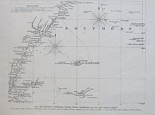
English: A 1929 presentation of an 1805/1806 map of the South Atlantic, including several phantom islands
Français : Carte avec une vue d'ensemble des de l'Atlantique sud. |
||||
| Datum | |||||
| Quelle | L'Illustration, 24/8/1929 | ||||
| Urheber | Autor/-in unbekannt | ||||
| Genehmigung (Weiternutzung dieser Datei) |
|
||||
Dateiversionen
Klicke auf einen Zeitpunkt, um diese Version zu laden.
| Version vom | Vorschaubild | Maße | Benutzer | Kommentar | |
|---|---|---|---|---|---|
| aktuell | 13:49, 5. Nov. 2019 | | 2.716 × 2.011 (933 KB) | Tangopaso | == {{int:filedesc}} == {{Information |Description= {{en|1=Map with an overview of the phantom islands in Southern Atlantic.}} {{fr|1=Carte avec une vue d'ensemble des îles fantômes de l'Atlantique sud.}} |Source=L'Illustration, 24/8/1929 |Author={{unknown}} |Date=1929 |Permission={{PD-old}} |other_versions= }} Category:L'Illustration, 1929 Category:Old maps of phantom islands Category:Old maps of the Atlantic Ocean Category:1805 maps |
Dateiverwendung
Die folgende Seite verwendet diese Datei:
Globale Dateiverwendung
Die nachfolgenden anderen Wikis verwenden diese Datei:
- Verwendung auf en.wikipedia.org
- Verwendung auf fr.wikipedia.org