Datei:Pike Nat Forest vicinity map.jpg
Zur Navigation springen
Zur Suche springen
Es ist keine höhere Auflösung vorhanden.
Pike_Nat_Forest_vicinity_map.jpg (507 × 430 Pixel, Dateigröße: 102 KB, MIME-Typ: image/jpeg)
![]()
Diese Datei und die Informationen unter dem roten Trennstrich werden aus dem zentralen Medienarchiv Wikimedia Commons eingebunden.
![]()
Beschreibung
| Beschreibung |
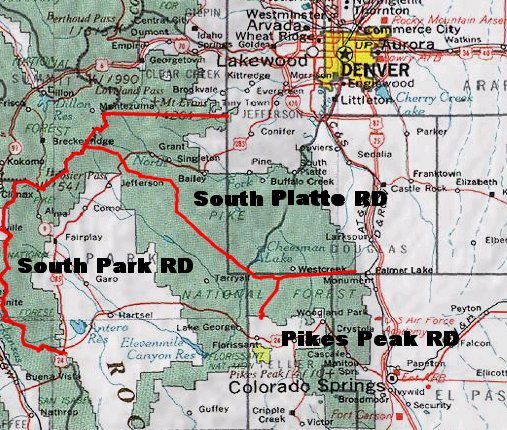
English: Map of Pike National Forest (green areas).
|
| Datum | Unbekanntes Datum |
| Quelle | http://www.fs.fed.us/r2/psicc/maps/pike_vicinity.jpg |
| Urheber | USDA |
Lizenz
This image is a work of the Forest Service of the United States Department of Agriculture. As a work of the U.S. federal government, the image is in the public domain.
|
Dateiversionen
Klicke auf einen Zeitpunkt, um diese Version zu laden.
| Version vom | Vorschaubild | Maße | Benutzer | Kommentar | |
|---|---|---|---|---|---|
| aktuell | 23:55, 23. Jul. 2007 | | 507 × 430 (102 KB) | Ken g6 | A map of the Pike National Forest. Sourced from [http://www.fs.fed.us/r2/psicc/maps/pike_vicinity.jpg this image], the picture was found on [http://www.fs.fed.us/r2/psicc/maps/pike.shtml this U.S.D.A. Forest Service web site]. |
Dateiverwendung
Die folgende Seite verwendet diese Datei:
Globale Dateiverwendung
Die nachfolgenden anderen Wikis verwenden diese Datei:
- Verwendung auf en.wikipedia.org
- Verwendung auf es.wikipedia.org
- Verwendung auf fa.wikipedia.org
- Verwendung auf www.wikidata.org