Datei:Prince Edward Island map 1775.jpg
Originaldatei (1.216 × 639 Pixel, Dateigröße: 167 KB, MIME-Typ: image/jpeg)
![]()
Diese Datei und die Informationen unter dem roten Trennstrich werden aus dem zentralen Medienarchiv Wikimedia Commons eingebunden.
![]()
Beschreibung
| Beschreibung |
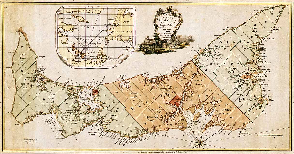
English: Map of Prince Edward Island in 1775. Titled: "A plan of the island of St. John with the divisions of the counties parishes & the lots as granted by government likewise the soundings round the coast and harbours. Surveyed by Capt. Holland. 1775." The island was the first of the new English colonies for which a general survey was conducted. Samuel Holland was in charge of the survey. Known as Île Saint-Jean at the time of the French, and later Saint John Island, it did not take its present name until 1799. This very detailed plan shows the projected counties, parishes, townships and lots on the island following the expulsion of the Acadians in 1758. Samuel Holland, surveyor general of the province of Quebec, surveyed the island in the fall of 1764. He identified the location of the capital and named it Charlottetown. The counties and townships are listed with their sizes in acres. Inset map of the Gulf of St. Lawrence. Decorative cartouche showing farming and fishing sceneries. |
||||||||||||||||||||
| Datum | |||||||||||||||||||||
| Quelle |
|
||||||||||||||||||||
| Urheber |
|
||||||||||||||||||||


Lizenz
|
Dieses Werk ist gemeinfrei, weil seine urheberrechtliche Schutzfrist abgelaufen ist. | |
| Es wurde festgestellt, dass diese Datei frei von bekannten Beschränkungen durch das Urheberrecht ist, alle verbundenen und verwandten Rechte eingeschlossen. | |
Dateiversionen
Klicke auf einen Zeitpunkt, um diese Version zu laden.
| Version vom | Vorschaubild | Maße | Benutzer | Kommentar | |
|---|---|---|---|---|---|
| aktuell | 03:52, 6. Dez. 2007 | | 1.216 × 639 (167 KB) | SriMesh | |
| 03:51, 6. Dez. 2007 |  | 1.216 × 639 (167 KB) | SriMesh | ||
| 03:45, 6. Dez. 2007 |  | 1.500 × 791 (1,02 MB) | SriMesh | {{Information |Description=Prince Edward Island map 1765 |Source=Library and Archives Canada |Date=2007-12-05 |Author=Holland, Samuel |Permission=unrestricted public domain material, which can be reproduced without permission. |
Dateiverwendung
Die folgende Seite verwendet diese Datei:
Globale Dateiverwendung
Die nachfolgenden anderen Wikis verwenden diese Datei:
- Verwendung auf bg.wikipedia.org
- Verwendung auf en.wikipedia.org
- Verwendung auf ka.wikipedia.org
- Verwendung auf mk.wikipedia.org
- Verwendung auf mn.wikipedia.org
- Verwendung auf pt.wikipedia.org
- Verwendung auf ro.wikipedia.org