Datei:Provinces maritimes langues.png
Zur Navigation springen
Zur Suche springen
Größe dieser Vorschau: 779 × 600 Pixel. Weitere Auflösungen: 312 × 240 Pixel | 624 × 480 Pixel | 998 × 768 Pixel | 1.280 × 985 Pixel | 2.535 × 1.951 Pixel
Originaldatei (2.535 × 1.951 Pixel, Dateigröße: 845 KB, MIME-Typ: image/png)
![]()
Diese Datei und die Informationen unter dem roten Trennstrich werden aus dem zentralen Medienarchiv Wikimedia Commons eingebunden.
![]()
Beschreibung
| Beschreibung |
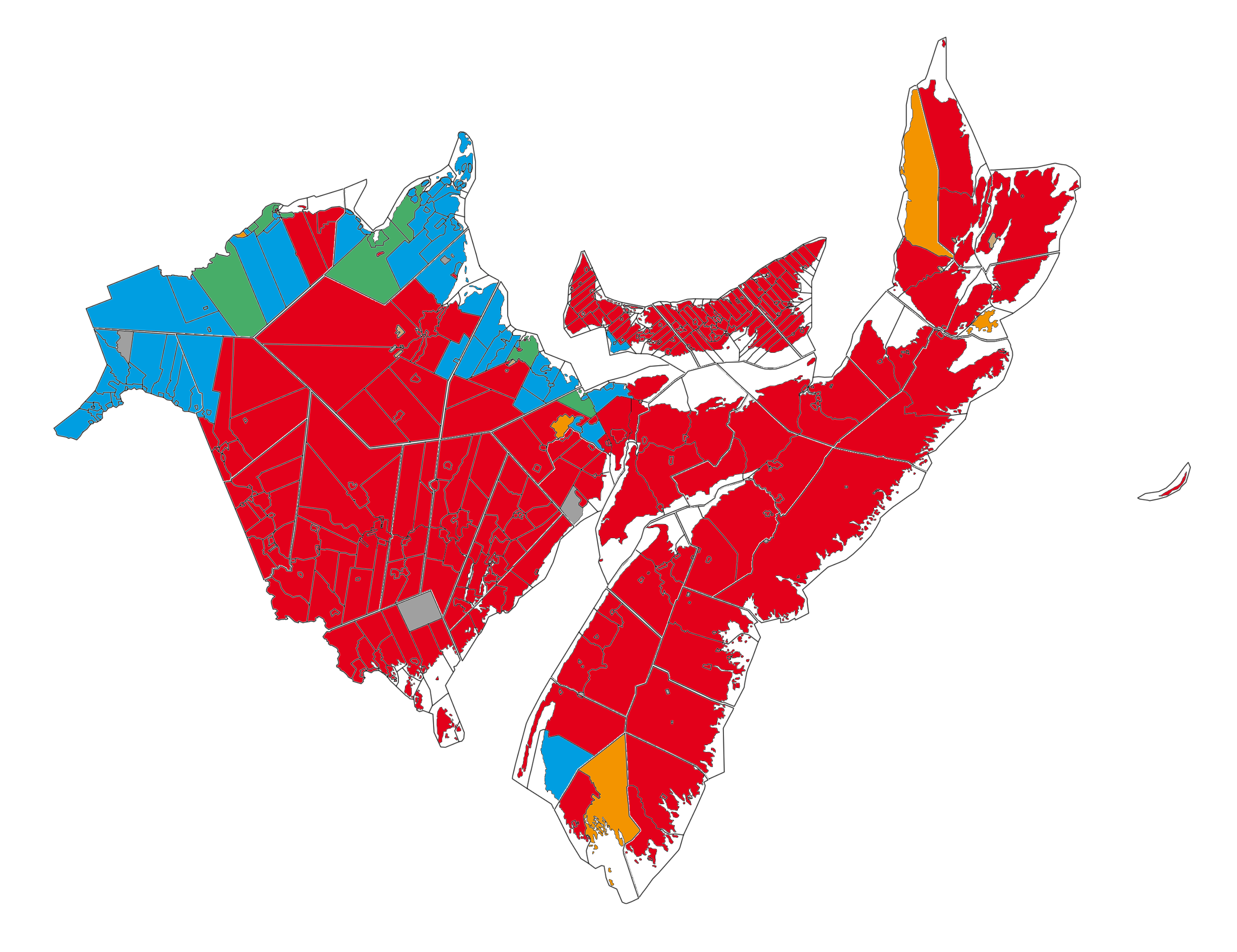
Français : Carte linguistique des provinces maritimes du Canada (source de données: Statistique Canada, recensement de 2006).
English: Map of language in the maritimes provinces of Canada (data source : Statistics Canada, 2006 census).
Euskara: Ama-hizkuntzaren mapa Maritimeetan (data source : Statistics Canada, 2006 census).
|
| Datum | |
| Quelle | Eigenes Werk |
| Urheber | Piotron |
Lizenz
Ich, der Urheberrechtsinhaber dieses Werkes, veröffentliche es hiermit unter der folgenden Lizenz:

|
Es ist erlaubt, die Datei unter den Bedingungen der GNU-Lizenz für freie Dokumentation, Version 1.2 oder einer späteren Version, veröffentlicht von der Free Software Foundation, zu kopieren, zu verbreiten und/oder zu modifizieren; es gibt keine unveränderlichen Abschnitte, keinen vorderen und keinen hinteren Umschlagtext.
Der vollständige Text der Lizenz ist im Kapitel GNU-Lizenz für freie Dokumentation verfügbar. |
Diese Datei ist unter der Creative-Commons-Lizenz „Namensnennung – Weitergabe unter gleichen Bedingungen 3.0 nicht portiert“ lizenziert.
- Dieses Werk darf von dir
- verbreitet werden – vervielfältigt, verbreitet und öffentlich zugänglich gemacht werden
- neu zusammengestellt werden – abgewandelt und bearbeitet werden
- Zu den folgenden Bedingungen:
- Namensnennung – Du musst angemessene Urheber- und Rechteangaben machen, einen Link zur Lizenz beifügen und angeben, ob Änderungen vorgenommen wurden. Diese Angaben dürfen in jeder angemessenen Art und Weise gemacht werden, allerdings nicht so, dass der Eindruck entsteht, der Lizenzgeber unterstütze gerade dich oder deine Nutzung besonders.
- Weitergabe unter gleichen Bedingungen – Wenn du das Material wiedermischst, transformierst oder darauf aufbaust, musst du deine Beiträge unter der gleichen oder einer kompatiblen Lizenz wie das Original verbreiten.
Du darfst es unter einer der obigen Lizenzen deiner Wahl verwenden.
Dateiversionen
Klicke auf einen Zeitpunkt, um diese Version zu laden.
| Version vom | Vorschaubild | Maße | Benutzer | Kommentar | |
|---|---|---|---|---|---|
| aktuell | 23:28, 21. Dez. 2010 | | 2.535 × 1.951 (845 KB) | Piotron | Colour correction in Kent County (New Brunswick) |
| 18:46, 31. Aug. 2010 |  | 2.535 × 1.951 (845 KB) | Piotron | White strip deleted. | |
| 18:38, 31. Aug. 2010 |  | 2.535 × 1.951 (843 KB) | Piotron | Small colour corrections in York County (New Brunswick). | |
| 17:18, 31. Aug. 2010 |  | 2.535 × 1.951 (843 KB) | Piotron | New Brunswick coastline improved. | |
| 17:46, 28. Aug. 2010 |  | 2.535 × 1.951 (838 KB) | Piotron | {{Information |Description={{fr|1=Carte linguistique des provinces maritimes du Canada. * rouge - majorité anglophone, moins de 33% de francophones * orange - majorité anglophone, plus de 33% de francophones * bleu - majorité francophone, moins de 33% |
Dateiverwendung
Die folgende Seite verwendet diese Datei:
Globale Dateiverwendung
Die nachfolgenden anderen Wikis verwenden diese Datei:
- Verwendung auf en.wikipedia.org
- Verwendung auf eu.wikipedia.org
- Verwendung auf fi.wikipedia.org
- Verwendung auf fr.wikipedia.org
- Verwendung auf fr.wikivoyage.org
- Verwendung auf pt.wikipedia.org
- Verwendung auf sc.wikipedia.org
- Verwendung auf sk.wikipedia.org