Datei:SDBayAreaNASA.jpg
Zur Navigation springen
Zur Suche springen

Größe dieser Vorschau: 600 × 600 Pixel. Weitere Auflösungen: 240 × 240 Pixel | 480 × 480 Pixel | 768 × 768 Pixel | 1.024 × 1.024 Pixel | 2.048 × 2.048 Pixel | 4.055 × 4.055 Pixel
Originaldatei (4.055 × 4.055 Pixel, Dateigröße: 13,45 MB, MIME-Typ: image/jpeg)
![]()
Diese Datei und die Informationen unter dem roten Trennstrich werden aus dem zentralen Medienarchiv Wikimedia Commons eingebunden.
![]()
Beschreibung
| Beschreibung |
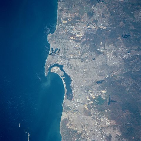
English: Three major features dominate this image of the southwest coast of California: the deep blue (dark) waters of the Pacific Ocean; the highly reflective, man-made urban and suburban environment along the coast; and the rugged, natural terrain of low mountain foothills of the Peninsular Ranges east of the urban development. The greater metropolitan area of San Diego (CA) and Tijuana (Mexico) with a combined population of approximately four million people can be identified as the lighter colored, highly reflective area on the image. Several types of infrastructure associated with the developed urban area are visible on this small-scale image. Reservoirs, including the lower Otay, Sweetwater, and St. Vicente Reservoirs, are the irregularly shaped, dark blue areas. The light-colored linear runways of Miramar Naval Air Station lie north of the densely populated area of San Diego. Interstate Highways 5 and 15 (light colored, linear features) radiate northward away from San Diego. The small square-shaped features along the edges of the bay are the many piers that jut into San Diego Bay. Mission Bay Harbor and Marina (dark area) is found along the coast north of the entrance to San Diego Bay. |
| Datum | 20. April 1998, 19:45:12 UTC |
| Quelle | Image courtesy of Earth Sciences and Image Analysis Laboratory, NASA Johnson Space Center: NASA photo STS090-758-17 (mission STS090, roll 758, frame 17); high-resolution version from ftp://eol.jsc.nasa.gov/EFS_highres_STS090_STS090-758-17.JPG |
| Urheber | NASA |
| Kameraposition | | Dieses und weitere Bilder auf OpenStreetMap |
|---|
Lizenz
| Diese Datei ist gemeinfrei (public domain), da sie von der NASA erstellt worden ist. Die NASA-Urheberrechtsrichtlinie besagt, dass „NASA-Material nicht durch Urheberrecht geschützt ist, wenn es nicht anders angegeben ist“. (NASA-Urheberrechtsrichtlinie-Seite oder JPL Image Use Policy). | ||
 |
Warnung:
|
| Bildnotizen | Diese Datei ist annotiert: Betrachte diese auf Commons. |
Dateiversionen
Klicke auf einen Zeitpunkt, um diese Version zu laden.
| Version vom | Vorschaubild | Maße | Benutzer | Kommentar | |
|---|---|---|---|---|---|
| aktuell | 00:24, 1. Jul. 2012 | | 4.055 × 4.055 (13,45 MB) | Closeapple | high-resolution version from ftp://eol.jsc.nasa.gov/EFS_highres_STS090_STS090-758-17.JPG |
| 02:16, 16. Feb. 2011 |  | 639 × 639 (344 KB) | 08OceanBeach SD | brightened | |
| 02:10, 24. Jan. 2011 |  | 639 × 639 (322 KB) | 08OceanBeach SD | {{Information |Description ={{en|1=Satellite map of the San Diego Urban and Bay Area from the National Aeronautics and Space Administration. Three major features dominate this image of the southwest coast of California: |
Dateiverwendung
Die folgende Seite verwendet diese Datei:
Globale Dateiverwendung
Die nachfolgenden anderen Wikis verwenden diese Datei:
- Verwendung auf ceb.wikipedia.org
- Verwendung auf en.wikipedia.org
- Verwendung auf eo.wikipedia.org
- Verwendung auf es.wikipedia.org
- Verwendung auf fr.wikipedia.org
- Verwendung auf he.wikipedia.org
- Verwendung auf it.wikipedia.org
- Verwendung auf nl.wikipedia.org
- Verwendung auf pl.wikipedia.org
- Verwendung auf ru.wikipedia.org
- Verwendung auf www.wikidata.org