Datei:Two-point equidistant projection SW.jpg
Zur Navigation springen
Zur Suche springen
Größe dieser Vorschau: 766 × 600 Pixel. Weitere Auflösungen: 307 × 240 Pixel | 613 × 480 Pixel | 981 × 768 Pixel | 1.280 × 1.003 Pixel | 2.044 × 1.601 Pixel
Originaldatei (2.044 × 1.601 Pixel, Dateigröße: 1,07 MB, MIME-Typ: image/jpeg)
![]()
Diese Datei und die Informationen unter dem roten Trennstrich werden aus dem zentralen Medienarchiv Wikimedia Commons eingebunden.
![]()
|
Beschreibung
| Beschreibung |
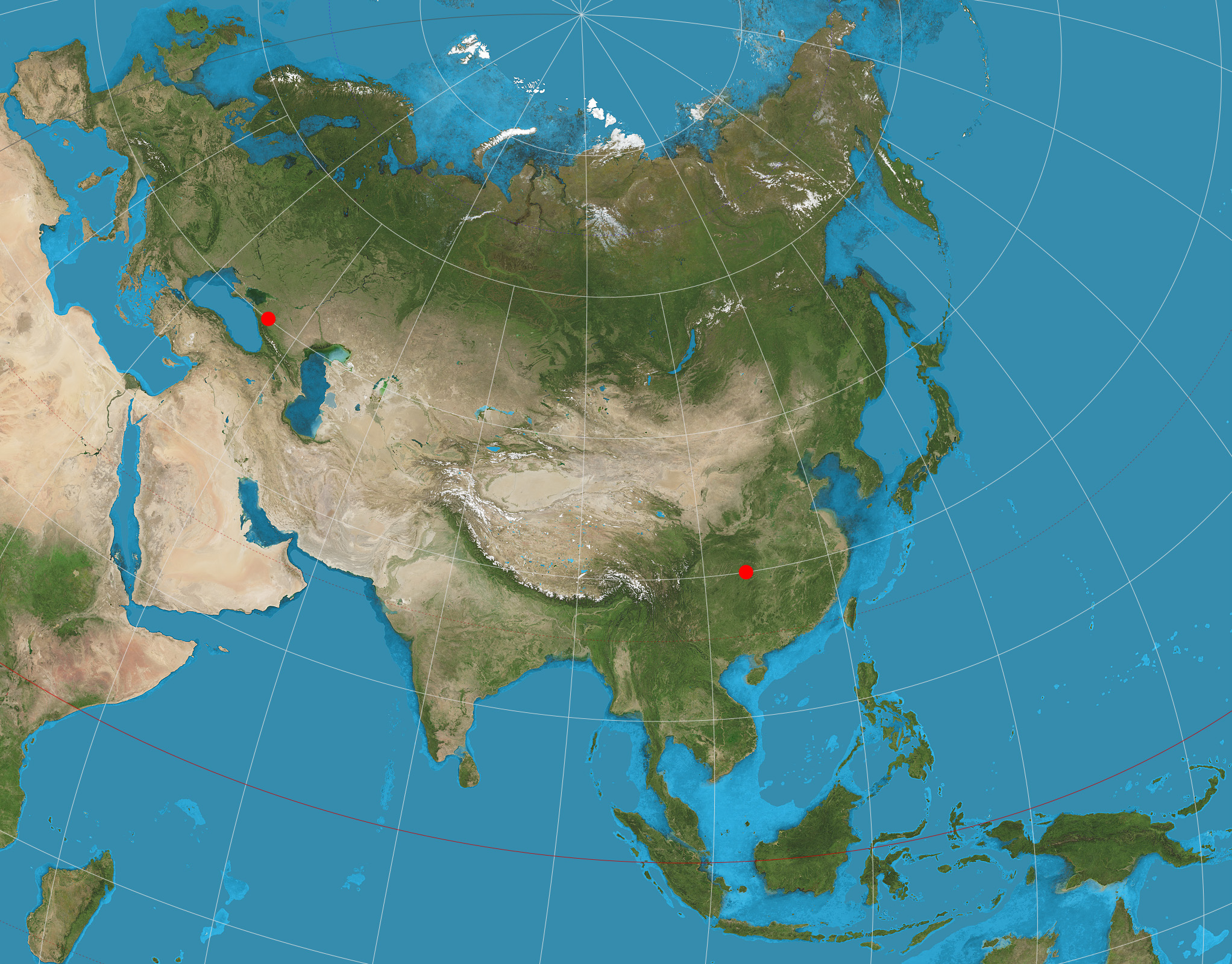
English: Eurasia on two-point equidistant projection. 15° graticule; two anchor points are (45°N, 40°E), (30°N, 110°E). Imagery is a derivative of NASA’s Blue Marble summer month composite with oceans lightened to enhance legibility and contrast. Image created with the Geocart map projection software. |
| Datum | |
| Quelle | Eigenes Werk |
| Urheber | Strebe |
Lizenz
Ich, der Urheber dieses Werkes, veröffentliche es unter der folgenden Lizenz:
Diese Datei ist unter der Creative-Commons-Lizenz „Namensnennung – Weitergabe unter gleichen Bedingungen 3.0 nicht portiert“ lizenziert.
- Dieses Werk darf von dir
- verbreitet werden – vervielfältigt, verbreitet und öffentlich zugänglich gemacht werden
- neu zusammengestellt werden – abgewandelt und bearbeitet werden
- Zu den folgenden Bedingungen:
- Namensnennung – Du musst angemessene Urheber- und Rechteangaben machen, einen Link zur Lizenz beifügen und angeben, ob Änderungen vorgenommen wurden. Diese Angaben dürfen in jeder angemessenen Art und Weise gemacht werden, allerdings nicht so, dass der Eindruck entsteht, der Lizenzgeber unterstütze gerade dich oder deine Nutzung besonders.
- Weitergabe unter gleichen Bedingungen – Wenn du das Material wiedermischst, transformierst oder darauf aufbaust, musst du deine Beiträge unter der gleichen oder einer kompatiblen Lizenz wie das Original verbreiten.
Dateiversionen
Klicke auf einen Zeitpunkt, um diese Version zu laden.
| Version vom | Vorschaubild | Maße | Benutzer | Kommentar | |
|---|---|---|---|---|---|
| aktuell | 02:49, 21. Nov. 2021 | | 2.044 × 1.601 (1,07 MB) | Reseletti | cropped to the actual content, removing a few lines of whitespace borders |
| 05:27, 19. Aug. 2011 |  | 2.058 × 1.616 (1,12 MB) | Strebe | Added anchor point symbols: the two points from which all distances are correct. | |
| 00:41, 16. Aug. 2011 |  | 2.058 × 1.602 (1,1 MB) | Strebe |
Dateiverwendung
Die folgende Seite verwendet diese Datei:
Globale Dateiverwendung
Die nachfolgenden anderen Wikis verwenden diese Datei:
- Verwendung auf ar.wikipedia.org
- Verwendung auf en.wikipedia.org
- Map projection
- User talk:Strebe
- Two-point equidistant projection
- Talk:Two-point equidistant projection
- Wikipedia:Featured pictures/Diagrams, drawings, and maps/Maps
- List of map projections
- Wikipedia:Featured pictures thumbs/35
- Wikipedia:Featured picture candidates/June-2013
- Wikipedia:Featured picture candidates/Map Projections Set
- Wikipedia:Picture of the day/August 2014
- Template:POTD/2014-08-30
- Wikipedia:Main Page history/2014 August 30
- Portal:Geography/Selected picture
- Verwendung auf es.wikipedia.org
- Verwendung auf fr.wikipedia.org
- Verwendung auf hu.wikipedia.org
- Verwendung auf id.wikipedia.org
- Verwendung auf it.wikipedia.org
- Verwendung auf nl.wikipedia.org
- Verwendung auf ru.wikipedia.org
- Verwendung auf uk.wikipedia.org
- Verwendung auf zh.wikipedia.org