Datei:USACE Black Butte Dam and Lake.jpg
Zur Navigation springen
Zur Suche springen

Größe dieser Vorschau: 800 × 526 Pixel. Weitere Auflösungen: 320 × 211 Pixel | 640 × 421 Pixel | 1.024 × 674 Pixel | 1.500 × 987 Pixel
Originaldatei (1.500 × 987 Pixel, Dateigröße: 619 KB, MIME-Typ: image/jpeg)
![]()
Diese Datei und die Informationen unter dem roten Trennstrich werden aus dem zentralen Medienarchiv Wikimedia Commons eingebunden.
![]()
| Beschreibung |
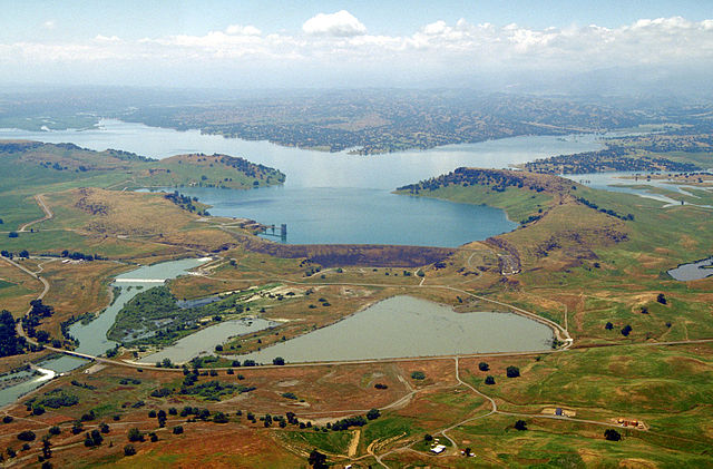
English: Aerial view of Black Butte Dam and Lake in Tehama County, California, USA. The dam was constructed in 1963 for flood control on Stony Creek. The dam is located approximately 9 miles (14.5 km) west of Orland, California.
Coordinates: 39°49′1.17″N 122°20′14.13″W / 39.8169917°N 122.3372583°W |
|||
| Ort | Tehama and Glenn Counties, California, USA | |||
| Datum | not specified or unknown | |||
| Quelle |
U.S. Army Corps of Engineers Digital Visual Library Image page Image description page Digital Visual Library home page |
|||
| Urheber | Michael Nevins, U.S. Army Corps of Engineers | |||
| Genehmigung (Weiternutzung dieser Datei) |
|
Dateiversionen
Klicke auf einen Zeitpunkt, um diese Version zu laden.
| Version vom | Vorschaubild | Maße | Benutzer | Kommentar | |
|---|---|---|---|---|---|
| aktuell | 07:47, 5. Mai 2007 | | 1.500 × 987 (619 KB) | DanMS | {{Information | Description = {{en|Aerial view of Black Butte Dam and Lake in Tehama County, California, USA. The dam was constructed in 1963 for flood control on Stony Creek. The dam is located approximately 9 miles (15.4 km) west of Orland, Californi |
Dateiverwendung
Die folgende Seite verwendet diese Datei:
Globale Dateiverwendung
Die nachfolgenden anderen Wikis verwenden diese Datei:
- Verwendung auf ar.wikipedia.org
- Verwendung auf arz.wikipedia.org
- Verwendung auf az.wikipedia.org
- Verwendung auf ceb.wikipedia.org
- Verwendung auf ce.wikipedia.org
- Verwendung auf cs.wikipedia.org
- Verwendung auf cy.wikipedia.org
- Verwendung auf en.wikipedia.org
- Verwendung auf en.wikivoyage.org
- Verwendung auf es.wikipedia.org
- Verwendung auf ga.wikipedia.org
- Verwendung auf hu.wikipedia.org
- Verwendung auf hy.wikipedia.org
- Verwendung auf no.wikipedia.org
- Verwendung auf pl.wikipedia.org
- Verwendung auf pt.wikipedia.org
- Verwendung auf ru.wikipedia.org
- Verwendung auf sr.wikipedia.org
- Verwendung auf tr.wikipedia.org
- Verwendung auf tt.wikipedia.org
- Verwendung auf vi.wikipedia.org
- Verwendung auf www.wikidata.org