Datei:Wales Carmarthenshire locator map.svg
Zur Navigation springen
Zur Suche springen

Größe der PNG-Vorschau dieser SVG-Datei: 502 × 600 Pixel. Weitere aus SVG automatisch erzeugte PNG-Grafiken in verschiedenen Auflösungen: 201 × 240 Pixel | 402 × 480 Pixel | 643 × 768 Pixel | 857 × 1.024 Pixel | 1.714 × 2.048 Pixel | 1.047 × 1.251 Pixel
Originaldatei (SVG-Datei, Basisgröße: 1.047 × 1.251 Pixel, Dateigröße: 151 KB)
![]()
Diese Datei und die Informationen unter dem roten Trennstrich werden aus dem zentralen Medienarchiv Wikimedia Commons eingebunden.
![]()
Beschreibung
| Beschreibung |
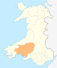
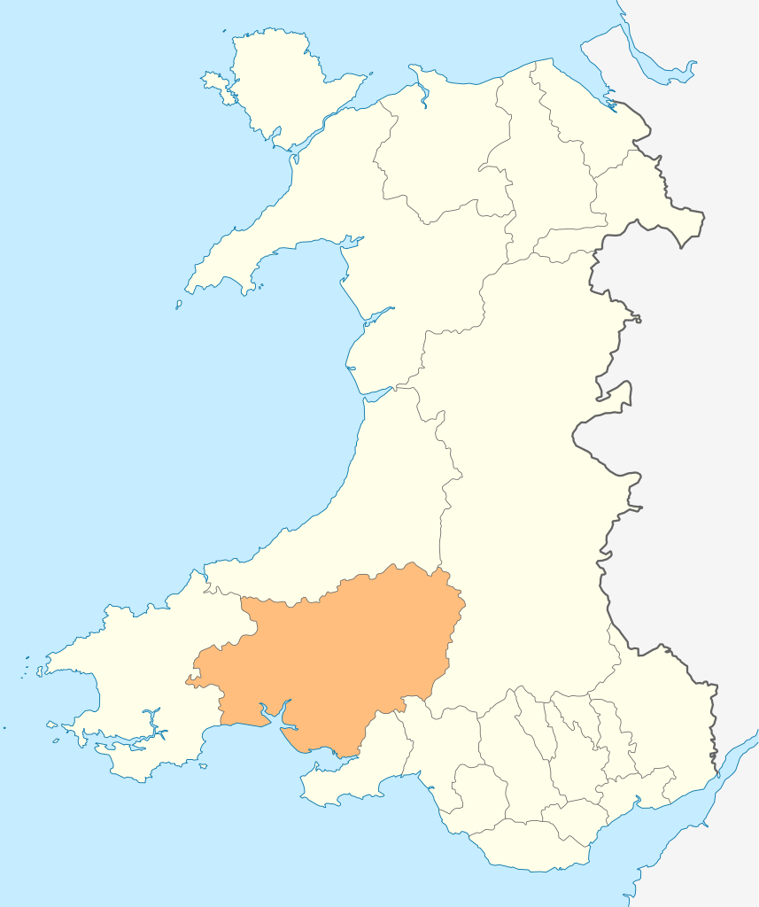
Deutsch: Lagekarte von Carmarthenshire in Wales
English: Locator map of Carmarthenshire in Wales |
| Datum | |
| Quelle | Eigenes Werk |
| Urheber | NordNordWest |
| Genehmigung (Weiternutzung dieser Datei) |
Ich, der Urheber dieses Werkes, veröffentliche es unter der folgenden Lizenz: Diese Datei ist unter der Creative-Commons-Lizenz „Namensnennung – Weitergabe unter gleichen Bedingungen 3.0 nicht portiert“ lizenziert.
|

|
Diese Karte wurde in der Kartenwerkstatt erstellt oder verbessert. Auch du kannst dort Karten vorschlagen, die zu erstellen, verändern oder übersetzen sind.
|
Dateiversionen
Klicke auf einen Zeitpunkt, um diese Version zu laden.
| Version vom | Vorschaubild | Maße | Benutzer | Kommentar | |
|---|---|---|---|---|---|
| aktuell | 20:49, 4. Mai 2010 | | 1.047 × 1.251 (151 KB) | NordNordWest | {{int:filedesc}} {{Information |Description= {{de|Lagekarte von Carmarthenshire in Wales}} {{en|Locator map of Carmarthenshire in Wales}} |Source={{Own}} |Date=2010-05-04 |Author={{U|NordNordWest}} |Permission={{self|cc-by-sa-3.0}} |other_versions= }} {{ |
Dateiverwendung
Die folgende Seite verwendet diese Datei:
Globale Dateiverwendung
Die nachfolgenden anderen Wikis verwenden diese Datei:
- Verwendung auf cs.wikipedia.org
- Verwendung auf en.wikipedia.org
- WWT Llanelli Wetlands Centre
- Carmarthenshire
- Sandy, Carmarthenshire
- Llanelli
- Carmarthen
- Llandeilo
- Newcastle Emlyn
- Whitland
- Burry Port
- Kidwelly
- Llandovery
- Laugharne
- St Clears
- Pendine
- Garreg Lwyd (Black Mountain)
- Llandybie
- Llanwrda
- Afon Cothi
- Cwmann
- Bancyfelin
- Talley
- Aber-arad
- Aber-giar
- Abergorlech
- Abernant, Carmarthenshire
- Cross Hands
- Pantyffynnon
- List of places in Carmarthenshire
- Brandy Hill, Wales
- Caio, Carmarthenshire
- Template:Carmarthenshire-geo-stub
- Bryn, Llanelli
- Pemberton, Carmarthenshire
- Dafen, Carmarthenshire
- Pendine Museum of Speed
- Usk Reservoir
- River Cywyn
- Five Roads
- Maesybont
- Glanymor
- Trefawr Track
- Bethlehem, Carmarthenshire
- Stradey
- Cross Inn
- Bronwydd
- Llanfihangel Rhos-y-Corn
- St Ishmael, Carmarthenshire
- Elvet Hundred
- River Amman
Weitere globale Verwendungen dieser Datei anschauen.