Datei:Xinjiang Internment Map, US-Aus Gov Assessment.jpg
Zur Navigation springen
Zur Suche springen
Größe dieser Vorschau: 800 × 495 Pixel. Weitere Auflösungen: 320 × 198 Pixel | 640 × 396 Pixel | 1.024 × 634 Pixel | 1.280 × 792 Pixel | 2.048 × 1.267 Pixel
Originaldatei (2.048 × 1.267 Pixel, Dateigröße: 150 KB, MIME-Typ: image/jpeg)
![]()
Diese Datei und die Informationen unter dem roten Trennstrich werden aus dem zentralen Medienarchiv Wikimedia Commons eingebunden.
![]()
Beschreibung
| Beschreibung |
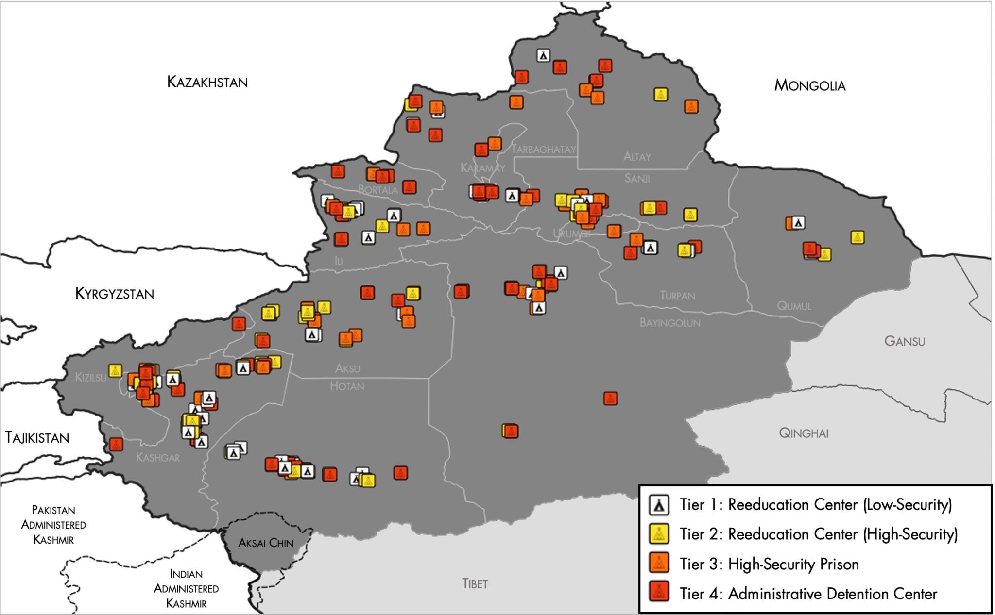
English: Map of the Xinjiang Internment Camps created by the RAND Corporation based on data collected by the US National Geospatial Intelligence Agency and the Australian Strategic Policy Institute. Open source here. |
||||||||
| Datum | |||||||||
| Quelle | https://www.tearline.mil/public_page/xinjiang-nighttime-1/ | ||||||||
| Urheber | National Geospatial Intelligence Agency, using data from the Australian Strategic Policy Institute, and administrative boundaries from GADM. | ||||||||
| Genehmigung (Weiternutzung dieser Datei) |
|


Dateiversionen
Klicke auf einen Zeitpunkt, um diese Version zu laden.
| Version vom | Vorschaubild | Maße | Benutzer | Kommentar | |
|---|---|---|---|---|---|
| aktuell | 07:05, 2. Mai 2021 | | 2.048 × 1.267 (150 KB) | Abovfold | Uploaded a work by {{w|National Geospatial Intelligence Agency}}, using data from the {{w|Australian Strategic Policy Institute}}, and administrative boundaries from {{w|GADM}}. from https://www.tearline.mil/public_page/xinjiang-nighttime-1/ with UploadWizard |
Dateiverwendung
Die folgende Seite verwendet diese Datei:
Globale Dateiverwendung
Die nachfolgenden anderen Wikis verwenden diese Datei:
- Verwendung auf ba.wikipedia.org
- Verwendung auf br.wikipedia.org
- Verwendung auf cs.wikipedia.org
- Verwendung auf el.wikipedia.org
- Verwendung auf en.wikipedia.org
- Verwendung auf es.wikipedia.org
- Verwendung auf fi.wikipedia.org
- Verwendung auf fr.wikipedia.org
- Verwendung auf ga.wikipedia.org
- Verwendung auf he.wikipedia.org
- Verwendung auf km.wikipedia.org
- Verwendung auf nl.wikipedia.org
- Verwendung auf or.wikipedia.org
- Verwendung auf pl.wikipedia.org
- Verwendung auf pt.wikipedia.org
- Verwendung auf ru.wikinews.org
- Verwendung auf sv.wikipedia.org
- Verwendung auf szl.wikipedia.org
- Verwendung auf tr.wikipedia.org
- Verwendung auf www.wikidata.org