Datei:Yellowstone Caldera map2.jpg
Zur Navigation springen
Zur Suche springen
Größe dieser Vorschau: 743 × 600 Pixel. Weitere Auflösungen: 298 × 240 Pixel | 595 × 480 Pixel | 952 × 768 Pixel | 1.269 × 1.024 Pixel | 2.538 × 2.048 Pixel | 3.072 × 2.479 Pixel
Originaldatei (3.072 × 2.479 Pixel, Dateigröße: 2,42 MB, MIME-Typ: image/jpeg)
![]()
Diese Datei und die Informationen unter dem roten Trennstrich werden aus dem zentralen Medienarchiv Wikimedia Commons eingebunden.
![]()

|
Dieses Bild des Typs Geology sollte als Vektorgrafik im SVG-Format neu erstellt werden. Vektorformate haben zahlreiche Vorteile; weitere Information unter Commons:Media for cleanup. Wenn dir eine SVG-Version dieses Bildes vorliegt, so lade diese bitte hoch. Nach dem Hochladen der Datei ist diese Vorlage auf der aktuellen Bildbeschreibungsseite durch die Vorlage {{Vector version available}}, oder kürzer {{Vva}}, zu ersetzen. Es ist empfohlen die neue SVG-Datei „Yellowstone Caldera map2.svg“ zu nennen – dann benötigt die Vorlage vector version available (bzw. vva) keinen Parameter.
|


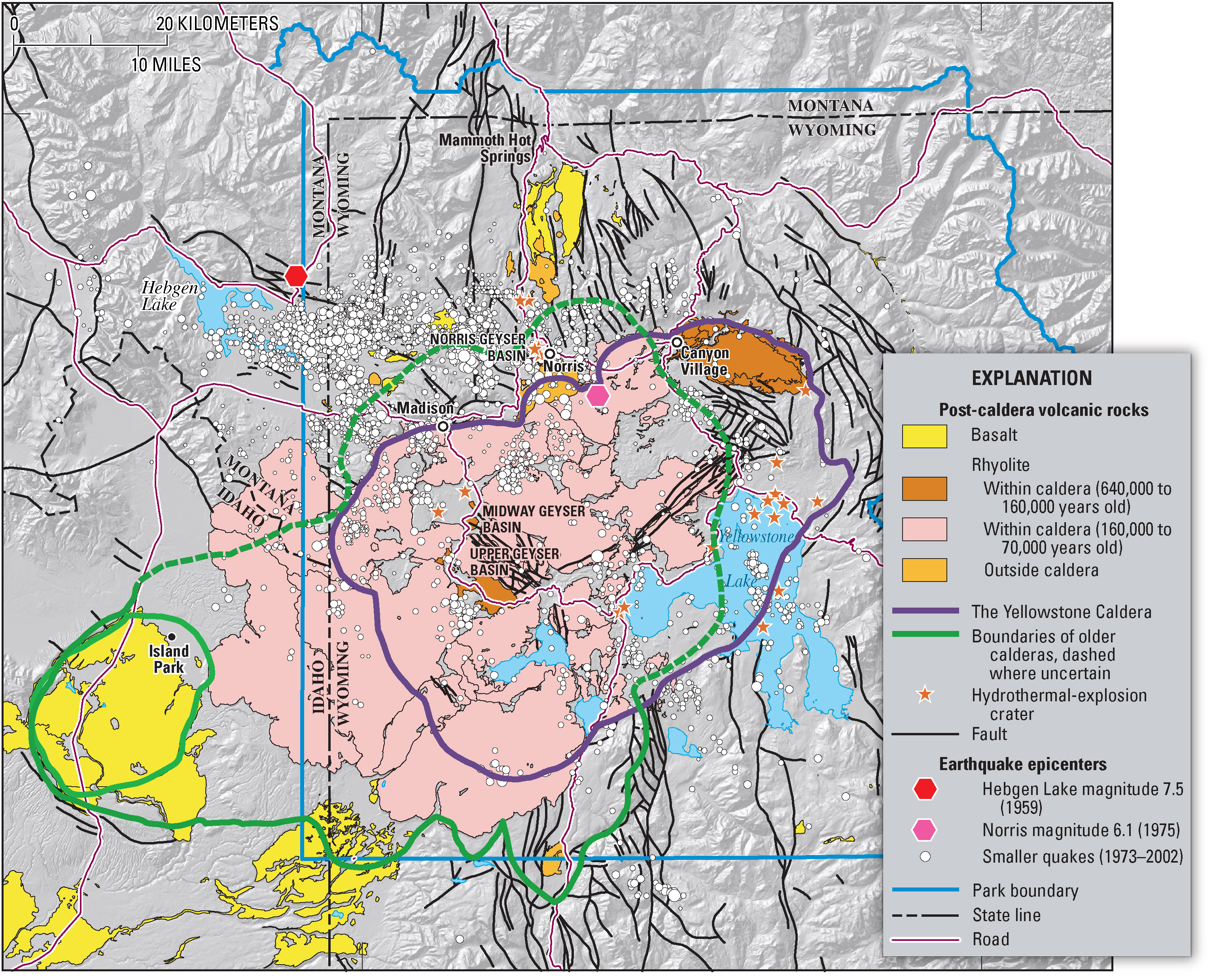
Geologic information regarding Yellowstone Caldera. From USGS. [1]
![[1]](https://pubs.usgs.gov/fs/2005/3024/press-images/fig_03_yellowstone_map.jpg)
Dieses Bild ist gemeinfrei (public domain), weil es Materialien beeinhaltet, die ursprünglich vom United States Geological Survey, einer Behörde des Innenministeriums der Vereinigten Staaten, stammen. Weitere Informationen finden Sie in den Urheberrechtsbestimmungen des USGS
|
Dateiversionen
Klicke auf einen Zeitpunkt, um diese Version zu laden.
| Version vom | Vorschaubild | Maße | Benutzer | Kommentar | |
|---|---|---|---|---|---|
| aktuell | 09:49, 16. Feb. 2006 | | 3.072 × 2.479 (2,42 MB) | Napa | Geologic information regarding Yellowstone Caldera. From USGS. [http://pubs.usgs.gov/fs/2005/3024/press-images/fig_03_yellowstone_map.jpg] {{PD-USGov-Interior-USGS}} Category:Geography of the United States Category:Maps of the United States |
Dateiverwendung
Die folgende Seite verwendet diese Datei:
Globale Dateiverwendung
Die nachfolgenden anderen Wikis verwenden diese Datei:
- Verwendung auf ar.wikipedia.org
- Verwendung auf ast.wikipedia.org
- Verwendung auf en.wikipedia.org
- Verwendung auf fi.wikipedia.org
- Verwendung auf fr.wikipedia.org
- Verwendung auf he.wikipedia.org
- Verwendung auf it.wikipedia.org
- Verwendung auf kk.wikipedia.org
- Verwendung auf ms.wikipedia.org
- Verwendung auf nl.wikipedia.org
- Verwendung auf nl.wikibooks.org
- Verwendung auf oc.wikipedia.org
- Verwendung auf pl.wikipedia.org
- Verwendung auf uk.wikipedia.org
- Verwendung auf www.wikidata.org