Benutzer:Atlasowa/geotagged WP
Zur Navigation springen
Zur Suche springen

Wikimedia and OpenStreetMap (Wikimania 2014 presentation) 
old Wikipedia App NearbyMap, no more... 


dewiki 
Geotagged articles in English Wikipedia Geotag-wikigrowth-scandinavia, 2011 (data source) 
Coordinates of the german Wikipedia created with PostGIS and QGIS, March 2010 
Wikimedia-Metrics-Meeting-July-11-2013-03 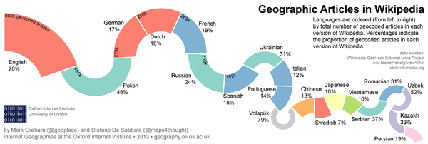
Wikipedia geotagged articles: This graph illustrate the percentage of geo-referenced articles in the twenty editions of Wikipedia containing the largest number of geo-referenced articles (Mark Graham, Stefano De Sabbata: Geographic intersections of languages in Wikipedia. In: Information Geographies at the Oxford Internet Institute. Abgerufen am 23. August 2014.) 
NEWS: At the moment (2015-11-30) we have (Source): 4,15 million entries as input:
- en 1145421
- de 772004
- sv 372494
- fr 293196
- nl 232555
- ru 226063
- pl 149819
- ja 106954
- ca 94353
- es 91030
- it 86936
- sr 65041
- cs 53493
- zh 52971
- uk 50251
- da 48126
- no 40229
- fa 39004
- eu 25054
- lt 24879
With interwikilinks we get an output for 273 languages.
Database-Dumps (2015-11)
- toollabs:wp-world/dumps/new_red0.gz Wikipedia-World as PostGIS-dumps
- Database structure (PostGIS)
All people with WMFLAbs-account can read and use the database u_kolossos on osmdb database server. (Helppage Connecting to OSM)
- http://geography.oii.ox.ac.uk/2013/12/geographic-intersections-of-languages-in-wikipedia/ Geocoded articles in Wikipedia languages
-
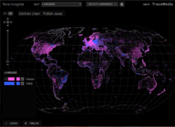 Tracemedia map dewiki-plwiki
 -
 TerraIncognita (Volapük Wikipedia)


Wikidata queries[Bearbeiten | Quelltext bearbeiten]
- wikiglobe geotagged Wikipedia globe (Created by Denny Vrandečić)
- Wikidata map@tools.wmflabs by Denny Vrandečić (mirror, small map, huge map)
- https://ddll.inf.tu-dresden.de/web/Wikidata/Maps-06-2015/en [1]

OSM Karten for Wikipedia[Bearbeiten | Quelltext bearbeiten]


- https://wikimania2014.wikimedia.org/wiki/Submissions/Wikimedia_and_OpenStreetMap:_History,_Current_Status,_and_Challenges
- T92963 Fix tool kmlexport oder Benutzer_Diskussion:Kolossos#WIWOSM "osm-on-ol"
- Dynamische Karten mit POI-Anzeige in Wikipedia-Artikeln, siehe [3] -> [4], statt bisheriger Krücken, Positionskartenfummelei (in jeder wiki-Sprache...)
- Kartenanzeige in der mobilen WP! (wie früher in der App[5], siehe auch T101144 Add OpenStreetMap to Nearby in Alpha build, T100315 Add OpenStreetMap to Nearby, T91481 Display coordinates in mobile version, T103409 Geohack should be mobile friendly)
- Spezial:In der Nähe mit Kartenanzeige (doh!) https://phabricator.wikimedia.org/T78654, WikimediaMobile: maps w/ nearby Adam Baso, Jun 18 2015
- T35980 Wikimedia-hosted OpenStreetMap (OSM) / mapnik tileservers wanted for mobile usage, https://wikitech.wikimedia.org/wiki/OSM_Tileserver [6]
- Wikipedia:Fragen_zur_Wikipedia/Archiv/2014/Woche_38#Wie bei Ausfall von WIWOSM vorgehen? Benutzer_Diskussion:Kolossos#Wikipedia:Fragen zur Wikipedia#Geokoordinaten: Vorschläge zur klareren Trennung WikiMiniAtlas, ausklappbare Karte und GeoHack, Benutzer_Diskussion:Kolossos#Question about tools
- Mailing List Wikitech: Maps maxsem Mar 18, 2015: "me and Yuri are resurrecting the project to have OpenStreetMap in Wikimedia starting in April. Because the initial part of this work will include researching options which will influence precise goals and this is yet to be done, we still can't commit to a precise timeline, but as a ballpark estimate I personally want to aim for serving PNG tiles at a reasonable, though not necessarily "dynamic maps on every WP page" scale by the end of Q4. Vector/multilingual maps would be the next stage. We will be mostly using Phabricator for planning, https://phabricator.wikimedia.org/tag/openstreetmap/ "
- meta:Grants:IEG/Wikimaps_Atlas (2013)
- http://umap.openstreetmap.fr/en/ , http://umap.osm.ch/de/ , https://wiki.openstreetmap.org/wiki/UMap commons-LinkSearch
- http://sharemap.org , meta:Grants:IEG/ShareMap commons:Category:Created with ShareMap
- http://gunnmap.herokuapp.com/ http://lert.co.nz/map/ commons:Category:Maps generated with GunnMap
- commons:Commons:Wikimaps
Karten[Bearbeiten | Quelltext bearbeiten]
Wikidata mit Geokoordinaten

Wikidata coordinates over the course of the first 40 days (or so) of enabling the coordinates data type. (30 July 2013)

Wikidata coordinates as of december 2013

ZUM VERGLEICH: englische WP-Artikel mit Geokoordinaten
- In diesen RENDER Karten (WD:RENDER) - bitte einmal mit Pfeilchen durchklicken - kann man die Verteilung von WP-Artikel mit Geokoordinaten in verschiedenen Wikipedia-Sprachversionen sehen.
Wikipedia-Artikel mit Geokoordinaten laut RENDER 2012/2013?
englische WP-Artikel mit Geokoordinaten

französische WP-Artikel mit Geokoordinaten

spanische WP-Artikel mit Geokoordinaten

portugiesische WP-Artikel mit Geokoordinaten

ratet mal!

russische WP-Artikel mit Geokoordinaten

kroatische WP-Artikel mit Geokoordinaten

türkische WP-Artikel mit Geokoordinaten

chinesische WP-Artikel mit Geokoordinaten

hebräische WP-Artikel mit Geokoordinaten

griechische WP-Artikel mit Geokoordinaten

katalanische WP-Artikel mit Geokoordinaten
Wikipedia-Artikel mit Geokoordinaten auf wikidata 2015 [7]

Wikidata-20150622-map-items-dewiki The map for Wikidata items with a sitelink from the specified wiki and with a coordinate

DescriptionWikidata-20150622-map-items-enwiki-2880x1440.png

DescriptionWikidata-20150622-map-items-cawiki-2880x1440.png

DescriptionWikidata-20150622-map-items-fawiki-2880x1440.png

DescriptionWikidata-20150622-map-items-ruwiki-2880x1440.png

DescriptionWikidata-20150622-map-items-plwiki-2880x1440.png

DescriptionWikidata-20150622-map-items-2880x1440.png Wikidata contains a significant amount of geographic data: over 2 million items have a

DescriptionWikidata-20150622-map-items-arwiki-2880x1440.png

DescriptionWikidata-20150622-map-items-rowiki-2880x1440.png

DescriptionWikidata-20150622-map-items-jawiki-2880x1440.png

DescriptionWikidata-20150622-map-items-commonswiki-2880x1440.png

DescriptionWikidata-20150622-map-items-viwiki-2880x1440.png

DescriptionWikidata-20150622-map-items-shwiki-2880x1440.png

DescriptionWikidata-20150622-map-items-warwiki-2880x1440.png

DescriptionWikidata-20150622-map-items-zhwiki-2880x1440.png

DescriptionWikidata-20150622-map-items-frwiki-2880x1440.png

svwiki

DescriptionWikidata-20150622-map-items-nlwiki-2880x1440.png

DescriptionWikidata-20150622-map-items-mswiki-2880x1440.png

DescriptionWikidata-20150622-map-items-srwiki-2880x1440.png

DescriptionWikidata-20150622-map-items-ptwiki-2880x1440.png

DescriptionWikidata-20150622-map-items-itwiki-2880x1440.png
WP-Artikel vs. Geonames Orte vs. Commons-Bilder mit Geokoordinaten

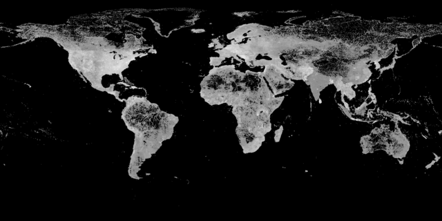
Worldwide density of geotagged Wikipedia entries 2013

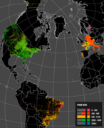
Worldwide density of GeoNames entries 2006

Worldwide density of GeoNames entries 2015

2,9 million geolocated images in Wikimedia Commons 2012

geolocated images in Wikimedia Commons 2014

5,2 million geolocated images in Wikimedia Commons 2015


