Datei:A 1940s-vintage quonset building at the Porter Farm, also known as Walter C. Porter Farm, near Terrell in Kaufman County, Texas LCCN2014633637.tif
Zur Navigation springen
Zur Suche springen

Größe der JPG-Vorschau dieser TIF-Datei: 800 × 534 Pixel. Weitere Auflösungen: 320 × 214 Pixel | 640 × 427 Pixel | 1.024 × 683 Pixel | 1.280 × 854 Pixel | 2.560 × 1.709 Pixel | 7.360 × 4.912 Pixel
Originaldatei (7.360 × 4.912 Pixel, Dateigröße: 206,9 MB, MIME-Typ: image/tiff)
![]()
Diese Datei und die Informationen unter dem roten Trennstrich werden aus dem zentralen Medienarchiv Wikimedia Commons eingebunden.
![]()
Beschreibung
| Beschreibung |
English: Title: A 1940s-vintage quonset building at the Porter Farm, also known as Walter C. Porter Farm, near Terrell in Kaufman County, Texas
Physical description: 1 photograph : digital, tiff file, color. Notes: Title, date, and keywords based on information provided by the photographer.; The farm was the site of the first cooperative farm demonstration, organized by Dr. Seaman A. Knapp, a U.S. Department of Agriculture agent, in 1903. The project successfully demonstrated methods expanding crop production.; Forms part of: Lyda Hill Texas Collection of Photographs in Carol M. Highsmith's America Project in the Carol M. Highsmith Archive.; Gift; The Lyda Hill Foundation; 2014; (DLC/PP-2014:054).; Credit line: The Lyda Hill Texas Collection of Photographs in Carol M. Highsmith's America Project, Library of Congress, Prints and Photographs Division. |
||||||||||||||||||||||||||
| Datum | Aufgenommen am 30. Mai 2014, 16:19 (gemäß Exif-Daten) | ||||||||||||||||||||||||||
| Quelle |
Library of Congress
|
||||||||||||||||||||||||||
| Urheber |
|
||||||||||||||||||||||||||
| Genehmigung (Weiternutzung dieser Datei) |
No known restrictions on publication.
|
||||||||||||||||||||||||||


| Kameraposition | | Dieses und weitere Bilder auf OpenStreetMap |
|---|
Lizenz
| Dieses Werk stammt aus der Carol M. Highsmith Archive-Sammlung der Library of Congress. Laut der Bibliothek gibt es keine bekannten Copyright-Einschränkungen in der Verwendung dieses Werkes. Carol M. Highsmith has stipulated that her photographs are in the public domain. Photographs of sculpture or other works of art may be restricted by the copyright of the artist. |
 |
Dateiversionen
Klicke auf einen Zeitpunkt, um diese Version zu laden.
| Version vom | Vorschaubild | Maße | Benutzer | Kommentar | |
|---|---|---|---|---|---|
| aktuell | 01:52, 8. Sep. 2016 | 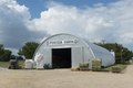 | 7.360 × 4.912 (206,9 MB) | Fæ | LOC 2014633637, Carol M. Highsmith collection. P140.12390 TIFF (206.9mb) |
| 01:52, 8. Sep. 2016 |  | 7.360 × 4.912 (206,9 MB) | Fæ | LOC 2014633637, Carol M. Highsmith collection. P140.12390 TIFF (206.9mb) |
Dateiverwendung
Die folgende Seite verwendet diese Datei: