Datei:DETAIL VIEW OF HYGEIA SPRING - West Baden Springs Hotel, State Route 56, West Baden Springs, Orange County, IN HAER IND,59-BADW,1-15.tif
Zur Navigation springen
Zur Suche springen

Größe der JPG-Vorschau dieser TIF-Datei: 800 × 573 Pixel. Weitere Auflösungen: 320 × 229 Pixel | 640 × 458 Pixel | 1.024 × 733 Pixel | 1.280 × 916 Pixel | 2.560 × 1.833 Pixel | 5.315 × 3.805 Pixel
Originaldatei (5.315 × 3.805 Pixel, Dateigröße: 19,29 MB, MIME-Typ: image/tiff)
![]()
Diese Datei und die Informationen unter dem roten Trennstrich werden aus dem zentralen Medienarchiv Wikimedia Commons eingebunden.
![]()
Beschreibung
| DETAIL VIEW OF HYGEIA SPRING - West Baden Springs Hotel, State Route 56, West Baden Springs, Orange County, IN | ||||
|---|---|---|---|---|
| Titel |
DETAIL VIEW OF HYGEIA SPRING - West Baden Springs Hotel, State Route 56, West Baden Springs, Orange County, IN |
|||
| Beschreibung |
Albright, Harrison; Sinclair, Lee Wiley; Westcott, Oliver J; Boucher, Jack E; Jandoli, Liz, transmitter |
|||
| Abgebildeter Ort | Indiana; Orange County; West Baden Springs | |||
| Datum | Documentation compiled after 1968 | |||
| Maße | 5 x 7 in. | |||
| Momentaner Standort |
Library of Congress Prints and Photographs Division Washington, D.C. 20540 USA http://hdl.loc.gov/loc.pnp/pp.print |
|||
| Inventarnummer |
HAER IND,59-BADW,1-15 |
|||
| Anerkennung |
|
|||
| Bemerkungen |
|
|||
| Referenzen |
|
|||
| Quelle | https://www.loc.gov/pictures/item/in0122.photos.065508p | |||
| Genehmigung (Weiternutzung dieser Datei) |
|
|||

| Objektposition | | Dieses und weitere Bilder auf OpenStreetMap |
|---|
Dateiversionen
Klicke auf einen Zeitpunkt, um diese Version zu laden.
| Version vom | Vorschaubild | Maße | Benutzer | Kommentar | |
|---|---|---|---|---|---|
| aktuell | 06:04, 18. Jul. 2014 | 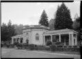 | 5.315 × 3.805 (19,29 MB) | Fæ | GWToolset: Creating mediafile for Fæ. HABS 16 July 2014 (1201:1400) |
Dateiverwendung
Die folgende Seite verwendet diese Datei: