Datei:Historic American Buildings Survey, P. Kent Fairbanks, Photographer June 30, 1967 NORTH AND EAST ELEVATIONS. - Wasatch County Courthouse, Main Street at Center Street, Heber HABS UTAH,26-HEBER,1-2.tif
Zur Navigation springen
Zur Suche springen

Größe der JPG-Vorschau dieser TIF-Datei: 739 × 600 Pixel. Weitere Auflösungen: 296 × 240 Pixel | 592 × 480 Pixel | 946 × 768 Pixel | 1.262 × 1.024 Pixel | 2.524 × 2.048 Pixel | 4.871 × 3.953 Pixel
Originaldatei (4.871 × 3.953 Pixel, Dateigröße: 18,37 MB, MIME-Typ: image/tiff)
![]()
Diese Datei und die Informationen unter dem roten Trennstrich werden aus dem zentralen Medienarchiv Wikimedia Commons eingebunden.
![]()
Beschreibung
| Historic American Buildings Survey, P. Kent Fairbanks, Photographer June 30, 1967 NORTH AND EAST ELEVATIONS. - Wasatch County Courthouse, Main Street at Center Street, Heber City, Wasatch County, UT | ||||
|---|---|---|---|---|
| Titel |
Historic American Buildings Survey, P. Kent Fairbanks, Photographer June 30, 1967 NORTH AND EAST ELEVATIONS. - Wasatch County Courthouse, Main Street at Center Street, Heber City, Wasatch County, UT |
|||
| Abgebildeter Ort | Utah; Wasatch County; Heber City | |||
| Datum | Documentation compiled after 1933 | |||
| Maße | 4 x 5 in. | |||
| Momentaner Standort |
Library of Congress Prints and Photographs Division Washington, D.C. 20540 USA http://hdl.loc.gov/loc.pnp/pp.print |
|||
| Inventarnummer |
HABS UTAH,26-HEBER,1-2 |
|||
| Anerkennung |
|
|||
| Bemerkungen |
|
|||
| Quelle | https://www.loc.gov/pictures/item/ut0126.photos.158863p | |||
| Genehmigung (Weiternutzung dieser Datei) |
|
|||

Dateiversionen
Klicke auf einen Zeitpunkt, um diese Version zu laden.
| Version vom | Vorschaubild | Maße | Benutzer | Kommentar | |
|---|---|---|---|---|---|
| aktuell | 02:24, 4. Aug. 2014 | 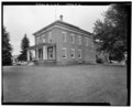 | 4.871 × 3.953 (18,37 MB) | Fæ | GWToolset: Creating mediafile for Fæ. HABS 2014-08-02 (3401:3600) |
Dateiverwendung
Die folgende Seite verwendet diese Datei: