Datei:NRC-regions-map.gif
Zur Navigation springen
Zur Suche springen
Es ist keine höhere Auflösung vorhanden.
NRC-regions-map.gif (550 × 415 Pixel, Dateigröße: 43 KB, MIME-Typ: image/gif)
![]()
Diese Datei und die Informationen unter dem roten Trennstrich werden aus dem zentralen Medienarchiv Wikimedia Commons eingebunden.
![]()
Beschreibung
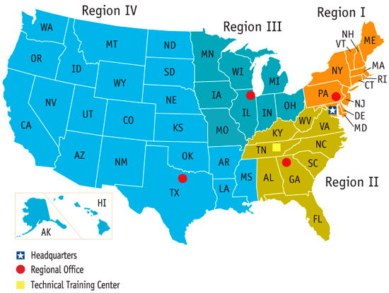
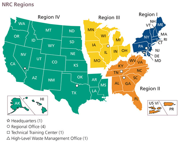
| Beschreibung | Map of the United States by Nuclear Regulatory Commission (NRC) Region (Now shows Mississippi in Region 4, rather than 2.) |
| Datum | Last revised prior to July 21, 2008 (previous: February 17, 2007) |
| Quelle | http://www.nrc.gov/images/info-finder/region-state/regions-map.gif |
| Urheber | Nuclear Regulatory Commission |
| Genehmigung (Weiternutzung dieser Datei) |
"Information generated by the NRC or developed under an NRC contract is not copyrighted, unless indicated otherwise. Non-copyrighted material can be reproduced without permission; citation of the NRC as the source of the information is appreciated." |
Lizenz
| This image is a work of a Nuclear Regulatory Commission employee, taken or made as part of that person's official duties. As a work of the U.S. federal government, the image is in the public domain in the United States. |
Dateiversionen
Klicke auf einen Zeitpunkt, um diese Version zu laden.
| Version vom | Vorschaubild | Maße | Benutzer | Kommentar | |
|---|---|---|---|---|---|
| aktuell | 19:49, 21. Jul. 2008 | | 550 × 415 (43 KB) | Wwoods | |
| 20:22, 12. Jan. 2007 |  | 560 × 350 (23 KB) | BigrTex | {{Information |Description=Map of the United States by Nuclear Regulatory Commission (NRC) Region |Source=http://www.nrc.gov/images/info-finder/region-state/regions-map.gif |Date=Last revised Tuesday, September 20, 2005 |Author=Nuclear Regulatory Commissi |
Dateiverwendung
Die folgenden 2 Seiten verwenden diese Datei:
Globale Dateiverwendung
Die nachfolgenden anderen Wikis verwenden diese Datei:
- Verwendung auf en.wikipedia.org
- Verwendung auf en.wikibooks.org
- Verwendung auf fr.wikipedia.org
- Verwendung auf ja.wikipedia.org
- Verwendung auf ko.wikipedia.org
- Verwendung auf pl.wikipedia.org
- Verwendung auf zh.wikipedia.org