Diskussion:Bosnische Ostbahn
Bauherrin / Betreiber[Quelltext bearbeiten]
Welche Gesellschaft errichtete die Bahn, wer hat sie betrieben? -- Reinhard Dietrich (Diskussion) 10:43, 15. Nov. 2016 (CET)
- Bosnisch-Herzegowinischen Staatsbahnen - BHStB (1883-1908) --My-wiki-photos (Diskussion) 05:16, 28. Nov. 2016 (CET)
Map Inaccuracies[Quelltext bearbeiten]
@Plutowiki, J budissin: Congratulations on redesigning the page. However, I have noticed some inaccuracies in the map of the line, for instance, river crossings. I didn't look any further, but I believe there are more of such inaccuracies. Starting from Sarajevo, there's one river crossing over the Miljacka River at the beginning of the line at Hrasno, where the line was making a turn to the east. That's what I found correct in the page map of the line. That's it when it comes to crossings over the Miljacka River. There's another river crossing over the Paljanska Miljacka River near the station Koran, east of Pale. However, there are river crossings over its tributaries in between Sarajevo and Pale. I will give you a link to a set of maps where you can follow the entire Bosnische Ostbahn. The index image is "pregledna25" at the bottom. Start with the map "525-2-4" (Sarajevo). The railway line was drawn into the map starting from the tunnel No. 2, because the abandoned railway bed from Sarajevo Novo up to the tunnel No. 2 was used for construction of the road. From there you will be able to follow the line on the subsequent maps, find all the tunnels and river crossings, thus helping you make the map of the line accurately. The link is: https://drive.google.com/open?id=0B9H3zE_0oHhLaEZBb0xyZ2VheTA --My-wiki-photos (Diskussion) 06:04, 28. Nov. 2016 (CET)
- Thanks for the comment. I have those maps as well (using them mainly for hiking) but didn't check the line map until now. Since I walked the tracks some years ago: You're right, there is no Miljacka crossing east of Bistrik. I'll correct that. --j.budissin+/- 09:09, 28. Nov. 2016 (CET)
- @J budissin: It looks much better now. A few more corrections for now: 1.a. The name of the creek is Dobrik, not Dovlički potok. 1.b. This is the bridge over the ravine with Dobrik. The caption under the thumbnail image on the page that reads Viadukt über die Miljacka Paljanska bei Pale needs to be changed. https://de.wikipedia.org/wiki/Datei:Narrow-Gauge-Railway_Ostbahn_Bridge-Dobrik_West-of-Pale.jpg 2. Paljanska Miljacka crossing is in between the station Koran and the tunnel No. 12. --My-wiki-photos (Diskussion) 17:47, 28. Nov. 2016 (CET)
- Those are two different creeks and as far as I remember there is (was) a bridge across Dovlički potok as well. So Dobrik is missing until now. I'll correct the caption. --j.budissin+/- 17:59, 28. Nov. 2016 (CET)
- It's possible. There were a few bridges between Bistrik and Pale. I can see that not all the tunnels and bridges are included in the map; only those that are more significant by their length, so it's just easier to replace Dovlički potok bridge with Dobrik, which is bigger. The same position in the map. --My-wiki-photos (Diskussion) 18:17, 28. Nov. 2016 (CET)
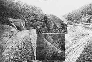
- @J budissin: I don't even remember any significant bridge over Dovlićki potok (map 525-2-4). Possibly it's a small beam bridge. If so, I would remove it from the map. However, there is a significant bridge right after the eastern portal of the tunnel No. 9 (map 526-1-3), which is not currently drawn into the map. The river is Bistrica, and it's the biggest tributary from Bistrik to Pale. There is an old postcard of the bridge and tunnel based on this photo: http://www.oberegger2.org/enzyklopaedie/images/bosnost_viadukt.jpg the location of which is misidentified on oberegger2.org. --My-wiki-photos (Diskussion) 18:19, 29. Nov. 2016 (CET)
- Bridge over Bistrica and eastern portal of tunnel No. 9 http://www.panoramio.com/photo/31894285 --My-wiki-photos (Diskussion) 19:38, 29. Nov. 2016 (CET)
- It's possible. There were a few bridges between Bistrik and Pale. I can see that not all the tunnels and bridges are included in the map; only those that are more significant by their length, so it's just easier to replace Dovlički potok bridge with Dobrik, which is bigger. The same position in the map. --My-wiki-photos (Diskussion) 18:17, 28. Nov. 2016 (CET)
- Those are two different creeks and as far as I remember there is (was) a bridge across Dovlički potok as well. So Dobrik is missing until now. I'll correct the caption. --j.budissin+/- 17:59, 28. Nov. 2016 (CET)
Brücke Čolin potok[Quelltext bearbeiten]
@Plutowiki, J budissin: I'd like to hear your opinion about whether or not to include this bridge in the map. It was a bridge over Čolin potok, and always visible from Baščaršija market place for so many years while the line was alive. There were 99 tunnels and 118 bridges originally built, and I know we cannot include them all. --My-wiki-photos (Diskussion) 23:00, 3. Dez. 2016 (CET)

- @My-wiki-photos I found an old postcard of the bridge. The photo could be added to the article. Where is the bridge? Between Bistrik and Dovlići? --Plutowiki (Diskussion) 01:37, 4. Dez. 2016 (CET)
- @Plutowiki: Yes, the bridge is between Bistrik and Dovlići. It was practically in Sarajevo, just a couple of hundred meters east of the Bistrik train station. When the line was dismantled in the early 1980's before the 1984 Winter Olympic Games, the railway bridge was also dismantled and a new road bridge was built at the same spot as part of the Sarajevo bypass. I have a better scan of that postcard published by Albert Thier. I will add it to Wikimedia soon. --My-wiki-photos (Diskussion) 05:30, 4. Dez. 2016 (CET)
- @My-wiki-photos. Thank you. The bridge Čolin potok is now in the article and in the map. --Plutowiki (Diskussion) 10:48, 4. Dez. 2016 (CET)
- It's not far from Alifakovac cemetery, isn't it? --j.budissin+/- 11:21, 4. Dez. 2016 (CET)
- @J budissin: Alifakovac cemetery is very close. --My-wiki-photos (Diskussion) 15:27, 4. Dez. 2016 (CET)
- Oh, I see. You should have looked at the image before ;) Yes, that place is quite present when looking at the south side of Sarajevo valley, so I guess we should name it here. --j.budissin+/- 15:55, 4. Dez. 2016 (CET)
- @Plutowiki, J budissin: I have just uploaded a better version of the postcard. --My-wiki-photos (Diskussion) 05:01, 5. Dez. 2016 (CET)
- @My-wiki-photos. Thank you. --Plutowiki (Diskussion) 22:16, 7. Dez. 2016 (CET)
- @Plutowiki, J budissin: I have just uploaded a better version of the postcard. --My-wiki-photos (Diskussion) 05:01, 5. Dez. 2016 (CET)
- Oh, I see. You should have looked at the image before ;) Yes, that place is quite present when looking at the south side of Sarajevo valley, so I guess we should name it here. --j.budissin+/- 15:55, 4. Dez. 2016 (CET)
- @J budissin: Alifakovac cemetery is very close. --My-wiki-photos (Diskussion) 15:27, 4. Dez. 2016 (CET)
- It's not far from Alifakovac cemetery, isn't it? --j.budissin+/- 11:21, 4. Dez. 2016 (CET)
- @My-wiki-photos. Thank you. The bridge Čolin potok is now in the article and in the map. --Plutowiki (Diskussion) 10:48, 4. Dez. 2016 (CET)
- @Plutowiki: Yes, the bridge is between Bistrik and Dovlići. It was practically in Sarajevo, just a couple of hundred meters east of the Bistrik train station. When the line was dismantled in the early 1980's before the 1984 Winter Olympic Games, the railway bridge was also dismantled and a new road bridge was built at the same spot as part of the Sarajevo bypass. I have a better scan of that postcard published by Albert Thier. I will add it to Wikimedia soon. --My-wiki-photos (Diskussion) 05:30, 4. Dez. 2016 (CET)
Kartendarstellung[Quelltext bearbeiten]
Wie ein User bei der letzten Änderung richtig anmerkte, ist man bei der Karte hier evt. etwas über's Ziel hinausgeschossen... Komplette Darstellung schön und gut, aber sie braucht eben auch bei meinem Bildschirm ca. 40% der Breite. (In der Mobilansicht funktioniert die Kartendarstellung gleich gar nicht richtig, allerdings auch bei anderen Strecken nicht...)
Vorschlag:
- Änderung von BS8-2 auf BS4
- Die Strecke nach Miljevina wäre eigentlich ein eigener Artikel, mit der Ostbahn hat sie - wie gleich am Anfang richtig vermerkt - nicht wirklich etwas zu tun. Allerdings wäre es (vorerst ?) ein nicht gerade großer Artikel...
- Bleibt die Strecke nach Uvac (denn diese gehört ja definitiv zur Ostbahn, sie war ja ursprünglich auch die Hauptstrecke), die müsste man - wie sonst auch öfter gemacht - zwischen Most na Drini und Sip einfügen, bevor es mit der Strecke nach Vardiste weitergeht
- eigentlich gehört die Strecke entsprechend der ursprünglichen Kilometrierung von oben nach unten gewendet - wäre hier aufgrund der wenigen Abzweigungen mit überschaubarem Aufwand möglich
- Beibehaltung JDZ-Kilometrierung? War ja höchstwahrscheinlich nur eine buchmäßige Änderung und überlädt die Tabelle nur noch zusätzlich. Könnte im Fließtext auch eingefügt werden, mit einer Gegenüberstellung bei den wichtigsten Bahnhöfen. Die Frage wäre noch, ob die bekannten (?) JZ-Streckenbänder mittlerweile gemeinfrei sind?
- Hat jemand eine Idee, ob das anders als mit dem Import in Excel besser funktionieren könnte? --Hattori 15 (Diskussion) 11:52, 14. Dez. 2023 (CET)