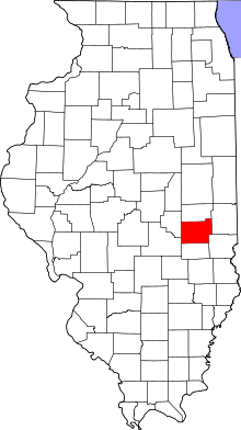
 Lage des Coles County in Illinois
Die Liste der Einträge im National Register of Historic Places im Coles County in Illinois führt alle Bauwerke und historischen Stätten im Coles County auf, die in das National Register of Historic Places aufgenommen wurden.[1]
| [2]
|
Name[3]
|
Bild
|
Eintragsdatum
|
Lage
|
Ort
|
Beschreibung
|
| 1
|
Airtight Bridge
|
|
1981
ID-Nr. 81000211
|
Nordöstlich von Charleston
39° 32′ 57″ N, 88° 5′ 36″ W39.549167-88.093333
| Charleston |
|
| 2
|
Blakeman Bridge
|
|
1981
ID-Nr. 81000212
|
Südöstlich von Charleston
39° 26′ 58″ N, 88° 9′ 1″ W39.449444-88.150278
| Charleston |
|
| 3
|
Alexander Briggs House
|
|
1980
ID-Nr. 80001341
|
210 Jackson Street
39° 29′ 36″ N, 88° 11′ 8″ W39.493333-88.185556
| Charleston |
|
| 4
|
Coles County Courthouse
|
 Coles County Courthouse Coles County Courthouse
|
1978
ID-Nr. 78001118
|
Charleston Public Square
39° 29′ 41″ N, 88° 10′ 28″ W39.494722-88.174444
| Charleston |
|
| 5
|
Fifteenth Street and Oklahoma Avenue Brick Street
|
|
1999
ID-Nr. 99001357
|
15th Street Ecke Oklahoma Avenue
39° 28′ 14″ N, 88° 21′ 39″ W39.470556-88.360833
| Mattoon |
|
| 6
|
Harrison St. Bridge
|
|
1981
ID-Nr. 81000213
|
Östlich von Charleston
39° 29′ 8″ N, 88° 6′ 57″ W39.485556-88.115833
| Charleston |
|
| 7
|
Health Education Building
|
 Health Education Building Health Education Building
|
1995
ID-Nr. 95000993
|
1611 4th Street
39° 28′ 54″ N, 88° 10′ 35″ W39.481667-88.176389
| Charleston |
|
| 8
|
Illinois Central Railroad Depot
|
|
2002
ID-Nr. 02000098
|
1718 Broadway Avenue
39° 28′ 56″ N, 88° 22′ 33″ W39.482222-88.375833
| Mattoon |
|
| 9
|
McFarland House
|
|
1991
ID-Nr. 91001690
|
895 Seventh Street
39° 29′ 22″ N, 88° 10′ 25″ W39.489444-88.173611
| Charleston |
|
| 10
|
Old Main
|
 Old Main Old Main
|
1981
ID-Nr. 81000214
|
Lincoln Avenue Ecke 7th Street
39° 29′ 3″ N, 88° 10′ 31″ W39.484167-88.175278
| Charleston |
|
| 11
|
Pemberton Hall and Gymnasium
|
|
1982
ID-Nr. 82002521
|
Lincoln Avenue Ecke 4th Street
39° 28′ 35″ N, 88° 11′ 6″ W39.476389-88.185
| Charleston |
|
| 12
|
Railway Express Agency Building
|
|
1994
ID-Nr. 94000974
|
1804 Western Avenue
39° 28′ 59″ N, 88° 22′ 36″ W39.483056-88.376667
| Mattoon |
|
| 13
|
Richard Roytek House
|
|
2011
ID-Nr. 11000030
|
3420 Richmond Avenue
39° 29′ 7″ N, 88° 24′ 0″ W39.485278-88.4
| Mattoon |
|
| 14
|
Dr. Hiram Rutherford House and Office
|
|
1982
ID-Nr. 82002523
|
14 South Pike Street
39° 38′ 55″ N, 88° 2′ 10″ W39.648611-88.036111
| Oakland |
|
| 15
|
Sixth, Seventh, and Tenth Street Stone Arch Bridges
|
|
2001
ID-Nr. 01000869
|
6th Street, 7th und 10th Street
39° 29′ 34″ N, 88° 10′ 25″ W39.492778-88.173611
| Charleston |
|
| 16
|
Starr Hotel
|
|
1994
ID-Nr. 94000975
|
1913-1923 Western Avenue
39° 28′ 59″ N, 88° 22′ 44″ W39.483056-88.378889
| Mattoon |
|
| 17
|
Stone Quarry Bridge
|
|
1981
ID-Nr. 81000211
|
Nordöstlich von Charleston
39° 30′ 47″ N, 88° 6′ 57″ W39.513056-88.115833
| Charleston |
|
| 18
|
U. S. Post Office
|
|
1979
ID-Nr. 79000818
|
1701 Charleston Avenue
39° 33′ 21,6″ N, 88° 14′ 46″ W39.556001-88.246118
| Mattoon |
|
| 19
|
Unity Church
|
|
1982
ID-Nr. 82002522
|
220 Western Avenue
39° 29′ 0″ N, 88° 23′ 0″ W39.483333-88.383333
| Mattoon |
|
| 20
|
Will Rogers Theatre and Commercial Block
|
 Will Rogers Theatre and Commercial Block Will Rogers Theatre and Commercial Block
|
1984
ID-Nr. 84001066
|
705-715 Monroe Avenue
39° 29′ 43″ N, 88° 10′ 28″ W39.495278-88.174444
| Charleston |
|
- ↑ Auszug aus dem National Register of Historic Places - Coles County Abgerufen am 22. November 2012
- ↑ a b Die Nummerierung in dieser Listenspalte ist an der vom National Park Service vorgelegten Reihenfolge der Einträge orientiert; die Farben unterscheiden verschiedene Schutzgebietstypen des Nationalparksystems mit landesweiter Bedeutung (z. B. National Historic Landmarks) von den sonstigen Einträgen im National Register of Historic Places.
- ↑ a b National Register Information System. In: National Register of Historic Places. National Park Service, abgerufen am 9. Juli 2010 (englisch).


