| [2]
|
Name[3]
|
Bild
|
Eintragsdatum
|
Lage
|
Ort
|
Beschreibung
|
| 1
|
Simeon Alexander, Jr., House
|
 Simeon Alexander, Jr., House Simeon Alexander, Jr., House
|
28. Mai 1991
ID-Nr. 91000598
|
Millers Falls Rd.
42° 38′ 19″ N, 72° 27′ 56,2″ W42.6386-72.4656
| Northfield |
|
| 2
|
Alvah Stone Mill
|
 Alvah Stone Mill Alvah Stone Mill
|
30. Juni 1997
ID-Nr. 97000562
|
440 Greenfield Rd.
42° 32′ 16″ N, 72° 32′ 20″ W42.537778-72.538889
| Montague |
|
| 3
|
Ashfield Plain Historic District
|
 Ashfield Plain Historic District Ashfield Plain Historic District
|
20. Sep. 1991
ID-Nr. 91001373
|
42° 31′ 37″ N, 72° 47′ 17″ W42.526944-72.788056
| Ashfield |
|
| 4
|
Bardwell’s Ferry Bridge
|
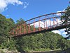 Bardwell’s Ferry Bridge Bardwell’s Ferry Bridge
weitere Bilder
|
10. Feb. 2000
ID-Nr. 00000076
|
Bardwell’s Ferry Rd.
42° 33′ 20″ N, 72° 40′ 41″ W42.555556-72.678056
| Conway |
|
| 5
|
Benson’s New Block and the Mohawk Chambers
|
 Benson’s New Block and the Mohawk Chambers Benson’s New Block and the Mohawk Chambers
|
11. März 2014
ID-Nr. 14000046
|
42° 35′ 16,8″ N, 72° 36′ 14,4″ W42.588-72.604
| Greenfield |
|
| 6
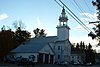
|
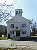
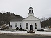
Bernardston Congregational Unitarian Church
|
 Bernardston Congregational Unitarian Church Bernardston Congregational Unitarian Church
|
18. März 1993
ID-Nr. 93000128
|
Church und Depot Sts.
42° 40′ 14″ N, 72° 33′ 0″ W42.670556-72.55
| Bernardston |
|
| 7
|
Bissell Bridge
|
 Bissell Bridge Bissell Bridge
|
26. Feb. 2004
ID-Nr. 04000083
|
Heath Rd.
42° 37′ 57″ N, 72° 52′ 10″ W42.6325-72.869444
| Charlemont |
|
| 8
|
Burkeville Covered Bridge
|
 Burkeville Covered Bridge Burkeville Covered Bridge
|
9. Sep. 1988
ID-Nr. 88001456
|
Main Poland Rd.
42° 29′ 1″ N, 72° 42′ 44″ W42.483611-72.712222
| Conway |
|
| 9
|
Charlemont Village Historic District
|
 Charlemont Village Historic District Charlemont Village Historic District
|
10. Feb. 1988
ID-Nr. 87001880
|
MA 2 (Main St.) zwischen South und Harmont Sts.
42° 37′ 40″ N, 72° 52′ 27″ W42.627778-72.874167
| Charlemont |
|
| 10
|
Colrain Center Historic District
|
 Colrain Center Historic District Colrain Center Historic District
|
15. Nov. 2006
ID-Nr. 06001057
|
42° 40′ 24″ N, 72° 41′ 52″ W42.673333-72.697778
| Colrain |
|
| 11
|
Conway Center Historic District
|
 Conway Center Historic District Conway Center Historic District
|
10. Sep. 1999
ID-Nr. 99001043
|
42° 30′ 31″ N, 72° 41′ 50″ W42.508611-72.697222
| Conway |
|
| 12
|
Dedic Site
|
 Dedic Site Dedic Site
|
16. Juli 1980
ID-Nr. 80000504
|
Die genaue Lage wird nicht veröffentlicht.
| Deerfield |
Archäologische Ausgrabung
|
| 13
|
Deerfield Valley Agricultural Society Fairgrounds
|
 Deerfield Valley Agricultural Society Fairgrounds Deerfield Valley Agricultural Society Fairgrounds
|
11. Mai 2011
ID-Nr. 11000267
|
Park St.
42° 37′ 51″ N, 72° 52′ 3″ W42.630833-72.8675
| Charlemont |
|
| 14
|
East Charlemont District School
|
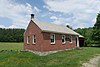 East Charlemont District School East Charlemont District School
|
7. März 2017
ID-Nr. 100000721
|
1811 MA 2
| Charlemont |
|
| 15
|
East Hawley Center Historic District
|
 East Hawley Center Historic District East Hawley Center Historic District
|
24. Juli 1992
ID-Nr. 92000951
|
42° 33′ 48″ N, 72° 52′ 43″ W42.563333-72.878611
| Hawley |
|
| 16
|
East Leverett Historic District
|
 East Leverett Historic District East Leverett Historic District
|
29. Jan. 2014
ID-Nr. 13001131
|
42° 26′ 17,8″ N, 72° 28′ 57,6″ W42.438281-72.48268
| Leverett |
|
| 17
|
East Main-High Street Historic District
|
 East Main-High Street Historic District East Main-High Street Historic District
|
16. März 1989
ID-Nr. 88002011
|
42° 35′ 20″ N, 72° 35′ 49″ W42.588889-72.596944
| Greenfield |
|
| 18
|
Franklin County Fairgrounds
|
 Franklin County Fairgrounds Franklin County Fairgrounds
|
15. Juni 2011
ID-Nr. 11000359
|
89 Wisdom Way
42° 34′ 44″ N, 72° 36′ 42″ W42.578889-72.611667
| Greenfield |
|
| 19
|
Garden Theater Block
|
 Garden Theater Block Garden Theater Block
|
1. Sep. 1983
ID-Nr. 83000591
|
353-367 Main St.
42° 35′ 15″ N, 72° 36′ 1″ W42.5875-72.600278
| Greenfield |
|
| 20
|
Gill Center Historic District
|
 Gill Center Historic District Gill Center Historic District
|
5. Nov. 2018
ID-Nr. 100003068
|
Center, Main, Cross, Boyle, River & Lyons Hill Rds.
42° 38′ 27″ N, 72° 30′ 9,3″ W42.640823-72.5025743
| Gill |
|
| 21
|
Maj. Joseph Griswold House
|
 Maj. Joseph Griswold House Maj. Joseph Griswold House
|
23. Feb. 1972
ID-Nr. 72000130
|
Upper St.
42° 35′ 25,7″ N, 72° 47′ 38,7″ W42.590468-72.794087
| Buckland |
|
| 22
|
Heath Center Historic District
|
 Heath Center Historic District Heath Center Historic District
|
25. Okt. 2007
ID-Nr. 07001103
|
42° 40′ 25″ N, 72° 49′ 19″ W42.673603-72.821944
| Heath |
Eine Erweiterung der Distriktgrenzen wurde am 24. August 2017 eingetragen.
|
| 23
|
Hill Cemetery and Parson Hubbard House Historic District
|
 Hill Cemetery and Parson Hubbard House Historic District Hill Cemetery and Parson Hubbard House Historic District
|
23. Aug. 2006
ID-Nr. 06000716
|
Old Village Rd.
42° 35′ 54″ N, 72° 41′ 16″ W42.598333-72.687778
| Shelburne |
|
| 24
|
King Philip’s Hill
|
 King Philip’s Hill King Philip’s Hill
|
16. Dez. 1981
ID-Nr. 81000106
|
Old Bernardston Road
42° 41′ 2″ N, 72° 28′ 35″ W42.683889-72.476389
| Northfield |
|
| 25
|
Leavitt-Hovey House
|
 Leavitt-Hovey House Leavitt-Hovey House
|
22. Dez. 1983
ID-Nr. 83003977
|
402 Main St.
42° 35′ 17″ N, 72° 35′ 58″ W42.588056-72.599444
| Greenfield |
|
| 26
|
Leverett Center Historic District
|
 Leverett Center Historic District Leverett Center Historic District
|
5. Dez. 2008
ID-Nr. 08001127
|
42° 27′ 4,6″ N, 72° 30′ 6,2″ W42.451286-72.501728
| Leverett |
|
| 27
|
Long Plain Cemetery
|
|
29. Juni 2020
ID-Nr. 100005304
|
19 Deport Rd.
42° 27′ 2,9″ N, 72° 31′ 39,2″ W42.4508003-72.5275501
| Leverett |
|
| 28
|
Main Street Historic District
|
 Main Street Historic District Main Street Historic District
|
13. Okt. 1988
ID-Nr. 88001908
|
42° 35′ 13″ N, 72° 36′ 5″ W42.586944-72.601389
| Greenfield |
|
| 29
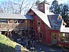
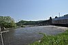
|
Millers Falls Village Historic District
|
 Millers Falls Village Historic District Millers Falls Village Historic District
weitere Bilder
|
22. Nov. 2021
ID-Nr. 100007171
|
42° 34′ 45″ N, 72° 29′ 36″ W42.579167-72.493333
| Montague |
|
| 30
|
Montague Center Historic District
|
 Montague Center Historic District Montague Center Historic District
|
16. Nov. 2001
ID-Nr. 01001236
|
42° 32′ 6″ N, 72° 32′ 5″ W42.535-72.534722
| Montague |
|
| 31
|
Moore’s Corner Historic District
|
 Moore’s Corner Historic District Moore’s Corner Historic District
|
19. Mai 2014
ID-Nr. 14000215
|
42° 29′ 40,2″ N, 72° 28′ 5,9″ W42.4945-72.4683
| Leverett |
|
| 32
|
New Salem Common Historic District
|
 New Salem Common Historic District New Salem Common Historic District
weitere Bilder
|
12. Apr. 1978
ID-Nr. 78000443
|
S. Main St.
42° 29′ 55″ N, 72° 19′ 54″ W42.498611-72.331667
| New Salem |
|
| 33
|
Newton Street School
|
 Newton Street School Newton Street School
|
27. Okt. 1988
ID-Nr. 88001907
|
Shelburne Rd.
42° 35′ 8″ N, 72° 36′ 52″ W42.585556-72.614444
| Greenfield |
|
| 34
|
North Cemetery
|
|
1. Juli 2020
ID-Nr. 100005276
|
42° 28′ 3″ N, 72° 30′ 1,6″ W42.4674976-72.5004399
| Leverett |
|
| 35
|
North Leverett Historic District
|
 North Leverett Historic District North Leverett Historic District
|
13. Juni 2014
ID-Nr. 14000326
|
42° 30′ 28,4″ N, 72° 29′ 31,2″ W42.5079-72.492
| Leverett |
|
| 36
|
Northfield Center Cemetery
|
 Northfield Center Cemetery Northfield Center Cemetery
|
13. Nov. 2004
ID-Nr. 04001220
|
Parker Ave.
42° 41′ 41″ N, 72° 27′ 40″ W42.694722-72.461111
| Northfield |
|
| 37
|
Northfield Main Street Historic District
|
 Northfield Main Street Historic District Northfield Main Street Historic District
|
8. Juli 1982
ID-Nr. 82004965
|
42° 41′ 50″ N, 72° 27′ 16″ W42.697222-72.454444
| Northfield |
|
| 38
|
Odd Fellows’ Hall
|
 Odd Fellows’ Hall Odd Fellows’ Hall
|
10. Mai 1979
ID-Nr. 79000345
|
1-5 State St.
42° 36′ 14″ N, 72° 44′ 23″ W42.603889-72.739722
| Buckland |
|
| 39
|
Old Deerfield Historic District
|
 Old Deerfield Historic District Old Deerfield Historic District
weitere Bilder
|
15. Okt. 1966
ID-Nr. 66000774
|
42° 33′ 4″ N, 72° 36′ 30″ W42.551111-72.608333
| Deerfield |
|
| 40
|
Orange Center Historic District
|
 Orange Center Historic District Orange Center Historic District
|
27. Apr. 1989
ID-Nr. 89000057
|
42° 35′ 24″ N, 72° 18′ 39″ W42.59-72.310833
| Orange |
|
| 41
|
Pine Street School
|
 Pine Street School Pine Street School
|
13. März 2002
ID-Nr. 02000156
|
13 Pine St.
42° 42′ 32″ N, 72° 26′ 50″ W42.708889-72.447222
| Northfield |
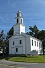
|
| 42
|
Powers Institute Historic District
|
 Powers Institute Historic District Powers Institute Historic District
|
18. März 1994
ID-Nr. 93000127
|
42° 40′ 16″ N, 72° 33′ 12″ W42.671111-72.553333
| Bernardston |
|
| 43
|
Riverside Archeological District
|
 Riverside Archeological District Riverside Archeological District
|
9. Juli 1975
ID-Nr. 75000256
|
Die genaue Lage wird nicht veröffentlicht.
| Greenfield und Gill |
Archäologische Ausgrabung
|
| 44
|
Riverside Village Historic District
|
 Riverside Village Historic District Riverside Village Historic District
|
18. Sep. 2017
ID-Nr. 100001617
|
42° 36′ 37,3″ N, 72° 32′ 55,4″ W42.6103699-72.5487107
| Gill |
|
| 45
|
Shelburne Falls Historic District
|
 Shelburne Falls Historic District Shelburne Falls Historic District
|
28. Jan. 1988
ID-Nr. 87002548
|
42° 36′ 11″ N, 72° 44′ 25″ W42.603056-72.740278
| Buckland und Shelburne |
|
| 46
|
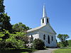
Shelburne Free Public Library
|
 Shelburne Free Public Library Shelburne Free Public Library
|
18. Juli 2016
ID-Nr. 16000453
|
233 Shelburne Center Rd.
42° 35′ 20,1″ N, 72° 41′ 19,6″ W42.588928-72.688787
| Shelburne |
|
| 47
|
Arthur A. Smith Covered Bridge
|
 Arthur A. Smith Covered Bridge Arthur A. Smith Covered Bridge
|
3. Feb. 1983
ID-Nr. 83000592
|
Lyonsville Rd.
42° 40′ 12″ N, 72° 43′ 9″ W42.67-72.719167
| Colrain |
|
| 48
|
South School
|
 South School South School
|
26. Dez. 2007
ID-Nr. 07001312
|
6 Schoolhouse Rd.
42° 25′ 11″ N, 72° 26′ 0″ W42.419722-72.433333
| Shutesbury |
|
| 49
|
Sunderland Center Historic District
|
 Sunderland Center Historic District Sunderland Center Historic District
|
15. März 2002
ID-Nr. 02000157
|
42° 27′ 59″ N, 72° 34′ 46,4″ W42.466397-72.579567
| Sunderland |
|
| 50
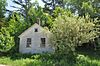
|
Old Tavern Farm
|
 Old Tavern Farm Old Tavern Farm
|
10. März 2005
ID-Nr. 05000120
|
817 Colrain Rd.
42° 37′ 20″ N, 72° 38′ 9″ W42.622222-72.635833
| Greenfield |
|
| 51
|
Turners Falls Historic District
|
 Turners Falls Historic District Turners Falls Historic District
|
2. Mai 1982
ID-Nr. 82004966
|
42° 36′ 30″ N, 72° 33′ 23″ W42.608333-72.556389
| Montague |
|
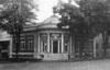
| 52
|
US Post Office-Greenfield Main
|
 US Post Office-Greenfield Main US Post Office-Greenfield Main
|
20. Dez. 1985
ID-Nr. 85003224
|
442 Main St.
42° 35′ 15″ N, 72° 35′ 53″ W42.5875-72.598056
| Greenfield |
|
| 53
|
Weldon Hotel
|
 Weldon Hotel Weldon Hotel
|
6. Aug. 1980
ID-Nr. 80000503
|
54 High St.
42° 35′ 26″ N, 72° 35′ 44″ W42.590556-72.595556
| Greenfield |
|
| 54
|
Wendell Town Common Historic District
|
 Wendell Town Common Historic District Wendell Town Common Historic District
|
21. Mai 1992
ID-Nr. 92000580
|
42° 32′ 55″ N, 72° 23′ 51″ W42.548611-72.3975
| Wendell |
|
| 55
|
West Whately Historic District
|
 West Whately Historic District West Whately Historic District
|
10. Okt. 2003
ID-Nr. 03001018
|
42° 26′ 17,9″ N, 72° 40′ 55,2″ W42.4383-72.682
| Whately |
|
| 56
|
Whately Center Historic District
|
 Whately Center Historic District Whately Center Historic District
|
11. Sep. 2003
ID-Nr. 03000920
|
42° 26′ 18″ N, 72° 38′ 9″ W42.438333-72.635833
| Whately |
|
| 57
|
Whitaker-Clary House
|
 Whitaker-Clary House Whitaker-Clary House
|
18. Juni 1975
ID-Nr. 75000257
|
Elm St.
42° 32′ 26″ N, 72° 18′ 58″ W42.540556-72.316111
| New Salem |
Sitz der Swift River Historical Society
|
| 58
|
The Wilder Homestead
|
 The Wilder Homestead The Wilder Homestead
|
24. Jan. 2011
ID-Nr. 10001178
|
Ashfield Rd.
42° 35′ 59″ N, 72° 46′ 44″ W42.599722-72.778889
| Buckland |
|
| 59
|
Robert Strong Woodward House and Studio
|
 Robert Strong Woodward House and Studio Robert Strong Woodward House and Studio
|
11. Jan. 2018
ID-Nr. 100001961
|
43 Upper St.
42° 35′ 15,9″ N, 72° 47′ 50,4″ W42.5877457-72.797328
| Buckland |
|


.jpg)


