Die Liste der Flughäfen und Flugplätze in Paraguay zeigt die Flughäfen und Flugplätze des südamerikanischen Staates Paraguay, geordnet nach Orten.
Namen in Fettschrift zeigen regelmäßigen Linienverkehr an.
| Ort
|
Departamento
|
ICAO-Code
|
IATA-Code
|
Name des Flughafens
|
Koordinaten
|
Foto
|
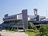
| Asunción / Luque
|
Departamento Central
|
SGAS
|
ASU
|
Silvio Pettirossi International Airport
|
25° 14′ 23″ S, 57° 31′ 9″ W-25.239722222222-57.519166666667
|
|
| Ayolas
|
Misiones
|
SGAY
|
AYO
|
Juan de Ayolas Airport
|
27° 22′ 14″ S, 56° 51′ 14″ W-27.370555555556-56.853888888889
|

|
| Ciudad del Este / Minga Guazú
|
Alto Paraná
|
SGES
|
AGT
|
Aeropuerto Internacional Guaraní
|
25° 27′ 20″ S, 54° 50′ 37″ W-25.455555555556-54.843611111111
|
|
| Concepción
|
Concepción
|
SGCO
|
CIO
|
Teniente Coronel Carmelo Peralta Airport
|
23° 16′ 30″ S, 57° 25′ 40″ W-23.275-57.427777777778
|
|
| Encarnación / Capitán Miranda
|
Itapúa
|
SGEN
|
ENO
|
Teniente Amin Ayub Gonzalez Airport
|
27° 18′ 0″ S, 55° 54′ 44″ W-27.3-55.912222222222
|

|
| Filadelfia
|
Boquerón
|
SGFI
|
FLM
|
Filadelfia Airport
|
22° 21′ 35″ S, 60° 3′ 13″ W-22.359722222222-60.053611111111
|
|
| Fuerte Olimpo
|
Alto Paraguay
|
SGOL
|
|
Tte. 1ro Inocencio Herebia Airport
|
21° 2′ 45″ S, 57° 53′ 0″ W-21.045833333333-57.883333333333
|
|
| Hernandarias
|
Alto Paraná
|
SGIB
|
|
Itaipu Airport
|
25° 24′ 25″ S, 54° 37′ 10″ W-25.406944444444-54.619444444444
|
|
| La Victoria
|
Alto Paraguay
|
SGLV
|
|
La Victoria Airport
|
22° 17′ 45″ S, 57° 52′ 0″ W-22.295833333333-57.866666666667
|
|
| Mariscal Estigarribia
|
Boquerón
|
SGME
|
ESG
|
Dr. Luis Maria Argaña International Airport
|
22° 2′ 42″ S, 60° 37′ 18″ W-22.045-60.621666666667
|
|
| Pedro Juan Caballero
|
Amambay
|
SGPJ
|
PJC
|
Dr. Augusto Roberto Fuster International Airport
|
22° 38′ 29″ S, 55° 49′ 47″ W-22.641388888889-55.829722222222
|
|
| Pilar
|
Ñeembucú
|
SGPI
|
PIL
|
Carlos Miguel Jiménez Airport
|
26° 52′ 53″ S, 58° 19′ 4″ W-26.881388888889-58.317777777778
|
|
| Puerto Vallemi
|
Concepción
|
SGVM
|
VMI
|
Dr. Juan Plate Airport
|
22° 9′ 30″ S, 57° 56′ 35″ W-22.158333333333-57.943055555556
|
|
| Salto del Guairá
|
Canindeyú
|
SGGR
|
|
Salto del Guairá Airport
|
24° 2′ 0″ S, 54° 21′ 0″ W-24.033333333333-54.35
|
|
| Santa Teresa
|
Amambay
|
SGST
|
|
Santa Teresa Airport
|
22° 37′ 25″ S, 56° 38′ 5″ W-22.623611111111-56.634722222222
|
|


